Property Record
Garrisonville Rd, Stafford, VA 22554
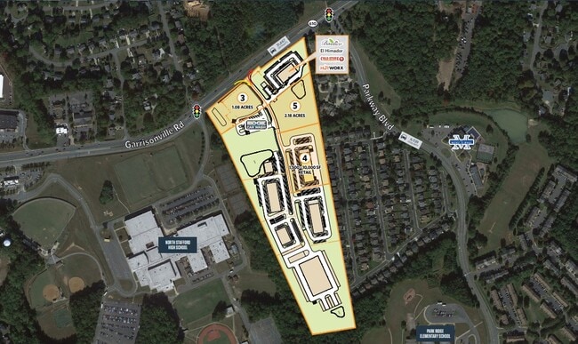

Current Lease Availabilities
Property Detail
Garrisonville Rd
Washington-Arlington-Alexandria, DC-VA-MD-WV
PARCEL 4 2.832 AC PATRIOTS CROSSING PM210000092
20-12D
STAFFORD
Commercialacreage
Virginia
B2
2.83 AC
2024
Stafford County
2025
Washington, DC
010210
NEARBY LISTINGS FOR SALE OR LEASE
DEMOGRAPHICS near Garrisonville Rd
1 mile
3 mile
5 mile
2025 Total Population
9,082
52,920
90,625
2030 Population
9,529
55,827
95,531
Pop Growth 2025-2030
+ 4.92%
+ 5.49%
+ 5.41%
Average Age
36
36
36
2025 Total Households
2,688
16,109
27,978
HH Growth 2025-2030
+ 5.02%
+ 5.56%
+ 5.51%
Median Household Inc
$145,472
$148,520
$145,332
Avg Household Size
3.30
3.20
3.10
2025 Avg HH Vehicles
3.00
2.00
2.00
Median Home Value
$449,708
$495,034
$484,905
Median Year Built
1992
1996
1996
Nearby Places
Map Layers
Map Styles
 Street
 Aerial
Layers
 Traffic
 Biking
Places
Listings with unknown addresses are not visible on the map
- Restaurants
- Banks
- Shops
- Fitness
- Groceries
PUBLIC TRANSPORTATION
COMMUTER RAIL
2 (Fredericksburg Line - Virginia Railway Express)
Drive
Walk
Distance
2 (Fredericksburg Line - Virginia Railway Express)
20 min
9.8 mi
Freight Ports
Virginia Port Authority - Richmond
Drive
Walk
Distance
Virginia Port Authority - Richmond
96 min
77.0 mi
Nearby Properties
Address
Land Use
TOTAL SIZE
Lot Size
Zoning
Address
Land Use
TOTAL SIZE
Lot Size
Zoning
175,700 SF
128.43 AC
R3
Address
Land Use
TOTAL SIZE
Lot Size
Zoning
Address
Land Use
TOTAL SIZE
Lot Size
Zoning
234,374 SF
16.23 AC
R3
Address
Land Use
TOTAL SIZE
Lot Size
Zoning
295,187 SF
88.50 AC
A1
Address
Land Use
TOTAL SIZE
Lot Size
Zoning
201,024 SF
9.43 AC
R3
Address
Land Use
TOTAL SIZE
Lot Size
Zoning
244,617 SF
61.73 AC
R3
Address
Land Use
TOTAL SIZE
Lot Size
Zoning
104,970 SF
23.29 AC
A1
Address
Land Use
TOTAL SIZE
Lot Size
Zoning
198,448 SF
19.17 AC
R2
Address
Land Use
TOTAL SIZE
Lot Size
Zoning
151,015 SF
36.62 AC
A1
Address
Land Use
TOTAL SIZE
Lot Size
Zoning
144,989 SF
13.12 AC
B2
Address
Land Use
TOTAL SIZE
Lot Size
Zoning
175,990 SF
50.21 AC
A1
Address
Land Use
TOTAL SIZE
Lot Size
Zoning
105,772 SF
9.57 AC
B2
Address
Land Use
TOTAL SIZE
Lot Size
Zoning
124,297 SF
8.66 AC
R3
Address
Land Use
TOTAL SIZE
Lot Size
Zoning
97,882 SF
9.26 AC
B2
Address
Land Use
TOTAL SIZE
Lot Size
Zoning
103,560 SF
21.68 AC
B3
Address
Land Use
TOTAL SIZE
Lot Size
Zoning
87,891 SF
38.57 AC
PD1
Address
Land Use
TOTAL SIZE
Lot Size
Zoning
168,780 SF
7.23 AC
R3
Address
Land Use
TOTAL SIZE
Lot Size
Zoning
116,700 SF
7.49 AC
B2
Address
Land Use
TOTAL SIZE
Lot Size
Zoning
97,516 SF
26.25 AC
A1
Address
Land Use
TOTAL SIZE
Lot Size
Zoning
160,130 SF
18.67 AC
B2
Address
Land Use
TOTAL SIZE
Lot Size
Zoning
146,710 SF
43.68 AC
R1
Address
Land Use
TOTAL SIZE
Lot Size
Zoning
125,365 SF
7.01 AC
B2
Address
Land Use
TOTAL SIZE
Lot Size
Zoning
134,693 SF
11.38 AC
B2
Address
Land Use
TOTAL SIZE
Lot Size
Zoning
87,891 SF
20.51 AC
A1
Address
Land Use
TOTAL SIZE
Lot Size
Zoning
125,357 SF
12.45 AC
B2
Address
Land Use
TOTAL SIZE
Lot Size
Zoning
75,159 SF
10 AC
R1
Address
Land Use
TOTAL SIZE
Lot Size
Zoning
80,533 SF
9.95 AC
B2
Address
Land Use
TOTAL SIZE
Lot Size
Zoning
84,974 SF
18.76 AC
R1
Address
Land Use
TOTAL SIZE
Lot Size
Zoning
95,535 SF
7.08 AC
B3
Address
Land Use
TOTAL SIZE
Lot Size
Zoning
76,187 SF
23.38 AC
A1
The World's #1 Commercial Real Estate Marketplace
Connect with us
© 2026 CoStar Group
The information above has been obtained from sources believed reliable. While we do not doubt its accuracy we have not verified it and make no guarantee, warranty or representation about it. It is your responsibility to independently confirm its accuracy and completeness. Any projections, opinions, assumptions, or estimates used are for example only and do not represent the current or future performance of the property. The value of this transaction to you depends on tax and other factors which should be evaluated by your tax, financial, and legal advisors. You and your advisors should conduct a careful, independent investigation of the property to determine to your satisfaction the suitability of the property for your needs.