Property Record
799 Highway 62 E, Mountain Home, AR 72653
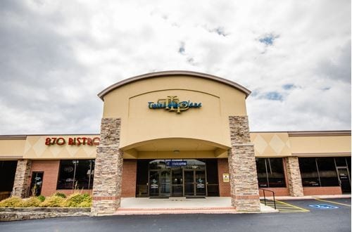

Property Detail
799 Highway 62 E
007-14045-000
PT SW 1/4 NE 1/4 12.053 ACRES
Theater
BAXTER
AE The base floodplain where base flood elevations are provided. AE Zones are now used on new format FIRMs instead of A1-A30 Zones.
Arkansas
2025
12.05 AC
2025
Arkansas North Area
950200
Other Market Areas
12,575 SF
Mountain Home, AR
NEARBY LISTINGS FOR SALE OR LEASE
-
-
View all Mountain Home listings for lease on LoopNet.com
DEMOGRAPHICS near 799 Highway 62 E
1 mile
3 mile
5 mile
2025 Total Population
4,320
15,960
21,756
2030 Population
4,282
16,020
21,981
Pop Growth 2025-2030
(0.88%)
+ 0.38%
+ 1.03%
Average Age
44
46
47
2025 Total Households
2,047
7,382
10,056
HH Growth 2025-2030
(0.83%)
+ 0.39%
+ 1.06%
Median Household Inc
$38,657
$43,792
$46,110
Avg Household Size
2.10
2.10
2.10
2025 Avg HH Vehicles
2.00
2.00
2.00
Median Home Value
$168,604
$174,231
$178,167
Median Year Built
1979
1980
1981
Nearby Places
Map Layers
Map Styles
 Street
 Aerial
Layers
 Traffic
 Biking
Places
Listings with unknown addresses are not visible on the map
- Restaurants
- Banks
- Shops
- Fitness
- Groceries
SALE & LEASE HISTORY
LISTING DATE
SALE/LEASE

Sep 25, 2016
For Lease
Nearby Properties
Address
Land Use
TOTAL SIZE
Lot Size
Zoning
Address
Land Use
TOTAL SIZE
Lot Size
Zoning
32,421 SF
5.07 AC
Address
Land Use
TOTAL SIZE
Lot Size
Zoning
220,476 SF
24.47 AC
Address
Land Use
TOTAL SIZE
Lot Size
Zoning
75,518 SF
24.82 AC
Address
Land Use
TOTAL SIZE
Lot Size
Zoning
58,490 SF
5 AC
Address
Land Use
TOTAL SIZE
Lot Size
Zoning
74,848 SF
7.90 AC
Address
Land Use
TOTAL SIZE
Lot Size
Zoning
124,870 SF
9.73 AC
Address
Land Use
TOTAL SIZE
Lot Size
Zoning
136,734 SF
11.63 AC
Address
Land Use
TOTAL SIZE
Lot Size
Zoning
99,747 SF
11.20 AC
Address
Land Use
TOTAL SIZE
Lot Size
Zoning
48,734 SF
3.04 AC
Address
Land Use
TOTAL SIZE
Lot Size
Zoning
9,440 SF
5 AC
Address
Land Use
TOTAL SIZE
Lot Size
Zoning
105,500 SF
19.58 AC
Address
Land Use
TOTAL SIZE
Lot Size
Zoning
66,209 SF
6.68 AC
Address
Land Use
TOTAL SIZE
Lot Size
Zoning
56,514 SF
6.14 AC
Address
Land Use
TOTAL SIZE
Lot Size
Zoning
35,280 SF
4.69 AC
Address
Land Use
TOTAL SIZE
Lot Size
Zoning
32,364 SF
6.16 AC
Address
Land Use
TOTAL SIZE
Lot Size
Zoning
38,646 SF
14.13 AC
Address
Land Use
TOTAL SIZE
Lot Size
Zoning
206,385 SF
21.11 AC
Address
Land Use
TOTAL SIZE
Lot Size
Zoning
33,180 SF
6 AC
Address
Land Use
TOTAL SIZE
Lot Size
Zoning
97,462 SF
21.24 AC
Address
Land Use
TOTAL SIZE
Lot Size
Zoning
20,277 SF
0.44 AC
Address
Land Use
TOTAL SIZE
Lot Size
Zoning
37,603 SF
2.16 AC
Address
Land Use
TOTAL SIZE
Lot Size
Zoning
42,060 SF
2.26 AC
Address
Land Use
TOTAL SIZE
Lot Size
Zoning
32,750 SF
7.21 AC
Address
Land Use
TOTAL SIZE
Lot Size
Zoning
12,000 SF
45.78 AC
Address
Land Use
TOTAL SIZE
Lot Size
Zoning
16,600 SF
4.07 AC
Address
Land Use
TOTAL SIZE
Lot Size
Zoning
3,850 SF
1.55 AC
Address
Land Use
TOTAL SIZE
Lot Size
Zoning
32,166 SF
5.01 AC
Address
Land Use
TOTAL SIZE
Lot Size
Zoning
7,802 SF
3.23 AC
Address
Land Use
TOTAL SIZE
Lot Size
Zoning
14,662 SF
1.08 AC
The World's #1 Commercial Real Estate Marketplace
Connect with us
© 2026 CoStar Group
The information above has been obtained from sources believed reliable. While we do not doubt its accuracy we have not verified it and make no guarantee, warranty or representation about it. It is your responsibility to independently confirm its accuracy and completeness. Any projections, opinions, assumptions, or estimates used are for example only and do not represent the current or future performance of the property. The value of this transaction to you depends on tax and other factors which should be evaluated by your tax, financial, and legal advisors. You and your advisors should conduct a careful, independent investigation of the property to determine to your satisfaction the suitability of the property for your needs.