Property Record
7Th St, Kenosha, WI 53140
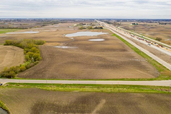

This Property Is For Sale
Property Detail
7Th St
Kenosha, WI
96-H NW FRAC'L 1/4 IN SEC 7 T2 R22 EX FOR HWY V465 P94 ALSO EXC PARCEL 4 TPP#1035-03-22-4.01 DOC#1587209 110.20 AC V1336 P149
82-4-222-072-0100
KENOSHA
Agriculturalland
Wisconsin
AE The base floodplain where base flood elevations are provided. AE Zones are now used on new format FIRMs instead of A1-A30 Zones.
100
2025
110.20 AC
2025
Kenosha East
000400
Chicago
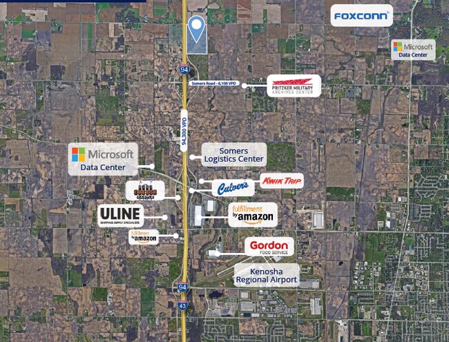
NEARBY LISTINGS FOR SALE OR LEASE
DEMOGRAPHICS near 7Th St
1 mile
3 mile
5 mile
2025 Total Population
77
2,300
17,608
2030 Population
76
2,284
17,816
Pop Growth 2025-2030
(1.30%)
(0.70%)
+ 1.18%
Average Age
46
47
42
2025 Total Households
35
1,013
6,254
HH Growth 2025-2030
(2.86%)
(0.69%)
+ 1.12%
Median Household Inc
$54,000
$68,233
$98,626
Avg Household Size
2.30
2.20
2.40
2025 Avg HH Vehicles
2.00
2.00
2.00
Median Home Value
$269,999
$262,890
$293,775
Median Year Built
1969
1975
1985
Nearby Places
Map Layers
Map Styles
 Street
 Aerial
Layers
 Traffic
 Biking
Places
Listings with unknown addresses are not visible on the map
- Restaurants
- Banks
- Shops
- Fitness
- Groceries
PUBLIC TRANSPORTATION
COMMUTER RAIL
Sturtevant Amtrak Station (Hiawatha Service - Amtrak)
Drive
Walk
Distance
Sturtevant Amtrak Station (Hiawatha Service - Amtrak)
13 min
7.8 mi
AIRPORT
General Mitchell International
Drive
Walk
Distance
General Mitchell International
29 min
22.4 mi
Freight Ports
Port Milwaukee
Drive
Walk
Distance
Port Milwaukee
33 min
26.3 mi
Nearby Properties
Address
Land Use
TOTAL SIZE
Lot Size
Zoning
Address
Land Use
TOTAL SIZE
Lot Size
Zoning
1,082,250 SF
58.93 AC
M2
Address
Land Use
TOTAL SIZE
Lot Size
Zoning
800,000 SF
48.22 AC
M2
Address
Land Use
TOTAL SIZE
Lot Size
Zoning
241.29 AC
Address
Land Use
TOTAL SIZE
Lot Size
Zoning
646,208 SF
44.09 AC
C2
Address
Land Use
TOTAL SIZE
Lot Size
Zoning
918,624 SF
65.18 AC
Address
Land Use
TOTAL SIZE
Lot Size
Zoning
513,760 SF
48.61 AC
C1
Address
Land Use
TOTAL SIZE
Lot Size
Zoning
795,475 SF
49.72 AC
Address
Land Use
TOTAL SIZE
Lot Size
Zoning
734,761 SF
43.56 AC
Address
Land Use
TOTAL SIZE
Lot Size
Zoning
525,048 SF
35.73 AC
M2
Address
Land Use
TOTAL SIZE
Lot Size
Zoning
509,017 SF
34.37 AC
Address
Land Use
TOTAL SIZE
Lot Size
Zoning
376,320 SF
35.18 AC
M2
Address
Land Use
TOTAL SIZE
Lot Size
Zoning
81.82 AC
Address
Land Use
TOTAL SIZE
Lot Size
Zoning
72.29 AC
Address
Land Use
TOTAL SIZE
Lot Size
Zoning
14,576 SF
25.05 AC
Address
Land Use
TOTAL SIZE
Lot Size
Zoning
43.43 AC
Address
Land Use
TOTAL SIZE
Lot Size
Zoning
20,872 SF
8.08 AC
Address
Land Use
TOTAL SIZE
Lot Size
Zoning
2,068 SF
27.64 AC
Address
Land Use
TOTAL SIZE
Lot Size
Zoning
2,361 SF
243.33 AC
Address
Land Use
TOTAL SIZE
Lot Size
Zoning
12,425 SF
15.11 AC
Address
Land Use
TOTAL SIZE
Lot Size
Zoning
19.79 AC
Address
Land Use
TOTAL SIZE
Lot Size
Zoning
17,024 SF
2.38 AC
Address
Land Use
TOTAL SIZE
Lot Size
Zoning
2,100 SF
13.39 AC
Address
Land Use
TOTAL SIZE
Lot Size
Zoning
77.94 AC
Address
Land Use
TOTAL SIZE
Lot Size
Zoning
1,440 SF
4.32 AC
Address
Land Use
TOTAL SIZE
Lot Size
Zoning
9.85 AC
Address
Land Use
TOTAL SIZE
Lot Size
Zoning
621 SF
22.40 AC
Address
Land Use
TOTAL SIZE
Lot Size
Zoning
4,581 SF
36.78 AC
Address
Land Use
TOTAL SIZE
Lot Size
Zoning
Address
Land Use
TOTAL SIZE
Lot Size
Zoning
5,056 SF
1.04 AC
Address
Land Use
TOTAL SIZE
Lot Size
Zoning
11,360 SF
1.62 AC
The World's #1 Commercial Real Estate Marketplace
Connect with us
© 2026 CoStar Group
The information above has been obtained from sources believed reliable. While we do not doubt its accuracy we have not verified it and make no guarantee, warranty or representation about it. It is your responsibility to independently confirm its accuracy and completeness. Any projections, opinions, assumptions, or estimates used are for example only and do not represent the current or future performance of the property. The value of this transaction to you depends on tax and other factors which should be evaluated by your tax, financial, and legal advisors. You and your advisors should conduct a careful, independent investigation of the property to determine to your satisfaction the suitability of the property for your needs.