Property Record
7Th St, Somers, WI 53171

This Property Is For Sale
Property Detail
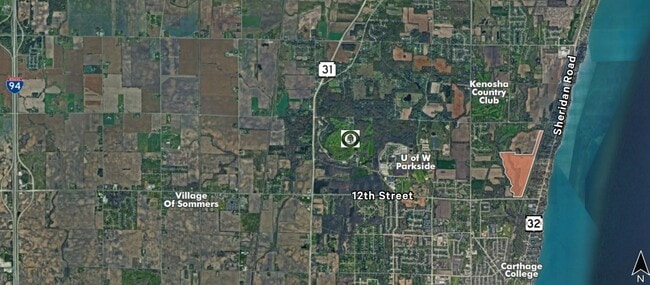
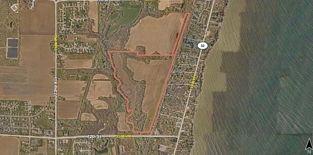
7Th St
Kenosha, WI
1462 H LOT 2 IN CSM# 2275 DOC# 1244084 PRT OF NW 1/4 OF NW 1/4 SEC 8 & PRT NE 1/4 & SE 1/4 & SW 1/4 OF NE 1/4 & SE 1/4 OF NW
83-4-223-074-0006
KENOSHA
Agriculturalland
Wisconsin
AE The base floodplain where base flood elevations are provided. AE Zones are now used on new format FIRMs instead of A1-A30 Zones.
2
2025
120 AC
2025
Kenosha East
000601
Chicago
NEARBY LISTINGS FOR SALE OR LEASE
DEMOGRAPHICS near 7Th St
1 mile
3 mile
5 mile
2025 Total Population
1,985
27,721
102,367
2030 Population
1,957
27,704
102,035
Pop Growth 2025-2030
(1.41%)
(0.06%)
(0.32%)
Average Age
41
41
39
2025 Total Households
931
11,437
41,129
HH Growth 2025-2030
(1.40%)
+ 0.02%
(0.31%)
Median Household Inc
$60,230
$68,463
$62,567
Avg Household Size
2.10
2.20
2.30
2025 Avg HH Vehicles
2.00
2.00
2.00
Median Home Value
$236,190
$271,658
$198,930
Median Year Built
1975
1977
1965
Nearby Places
Map Layers
Map Styles
 Street
 Aerial
Layers
 Traffic
 Biking
Places
Listings with unknown addresses are not visible on the map
- Restaurants
- Banks
- Shops
- Fitness
- Groceries
PUBLIC TRANSPORTATION
COMMUTER RAIL
Kenosha Station (Union Pacific North Line - Northeast Illinois Regional Commuter Railroad (Metra))
Drive
Walk
Distance
Kenosha Station (Union Pacific North Line - Northeast Illinois Regional Commuter Railroad (Metra))
9 min
4.5 mi
AIRPORT
General Mitchell International
Drive
Walk
Distance
General Mitchell International
42 min
30.2 mi
Freight Ports
Port Milwaukee
Drive
Walk
Distance
Port Milwaukee
47 min
34.0 mi
Nearby Properties
Address
Land Use
TOTAL SIZE
Lot Size
Zoning
Address
Land Use
TOTAL SIZE
Lot Size
Zoning
773 SF
21.36 AC
Address
Land Use
TOTAL SIZE
Lot Size
Zoning
21,072 SF
24.33 AC
RM2
Address
Land Use
TOTAL SIZE
Lot Size
Zoning
16,466 SF
19.09 AC
RM2
Address
Land Use
TOTAL SIZE
Lot Size
Zoning
26,500 SF
17.79 AC
RM2
Address
Land Use
TOTAL SIZE
Lot Size
Zoning
183,173 SF
9.73 AC
RM3
Address
Land Use
TOTAL SIZE
Lot Size
Zoning
88,473 SF
8.98 AC
B2
Address
Land Use
TOTAL SIZE
Lot Size
Zoning
15,084 SF
34.20 AC
Address
Land Use
TOTAL SIZE
Lot Size
Zoning
9,860 SF
14.55 AC
RM2
Address
Land Use
TOTAL SIZE
Lot Size
Zoning
32,000 SF
3.97 AC
IP
Address
Land Use
TOTAL SIZE
Lot Size
Zoning
59,660 SF
1.22 AC
RM3
Address
Land Use
TOTAL SIZE
Lot Size
Zoning
12,420 SF
6.58 AC
RM2
Address
Land Use
TOTAL SIZE
Lot Size
Zoning
84,950 SF
8.11 AC
Address
Land Use
TOTAL SIZE
Lot Size
Zoning
75,932 SF
4.10 AC
RM2
Address
Land Use
TOTAL SIZE
Lot Size
Zoning
45,608 SF
1.31 AC
IP
Address
Land Use
TOTAL SIZE
Lot Size
Zoning
30.06 AC
Address
Land Use
TOTAL SIZE
Lot Size
Zoning
26,162 SF
3.58 AC
RM2
Address
Land Use
TOTAL SIZE
Lot Size
Zoning
8.17 AC
Address
Land Use
TOTAL SIZE
Lot Size
Zoning
625 SF
3.21 AC
Address
Land Use
TOTAL SIZE
Lot Size
Zoning
16,222 SF
2.44 AC
RM2
Address
Land Use
TOTAL SIZE
Lot Size
Zoning
Address
Land Use
TOTAL SIZE
Lot Size
Zoning
26,500 SF
2.81 AC
RM2
Address
Land Use
TOTAL SIZE
Lot Size
Zoning
10.12 AC
Address
Land Use
TOTAL SIZE
Lot Size
Zoning
13,224 SF
8.88 AC
Address
Land Use
TOTAL SIZE
Lot Size
Zoning
Address
Land Use
TOTAL SIZE
Lot Size
Zoning
22,958 SF
3.09 AC
RM3
Address
Land Use
TOTAL SIZE
Lot Size
Zoning
26,222 SF
2.47 AC
RM2
Address
Land Use
TOTAL SIZE
Lot Size
Zoning
20,110 SF
3.20 AC
IP
Address
Land Use
TOTAL SIZE
Lot Size
Zoning
19,282 SF
4.99 AC
IP
Address
Land Use
TOTAL SIZE
Lot Size
Zoning
19.15 AC
Address
Land Use
TOTAL SIZE
Lot Size
Zoning
14.94 AC
The World's #1 Commercial Real Estate Marketplace
Connect with us
© 2026 CoStar Group
The information above has been obtained from sources believed reliable. While we do not doubt its accuracy we have not verified it and make no guarantee, warranty or representation about it. It is your responsibility to independently confirm its accuracy and completeness. Any projections, opinions, assumptions, or estimates used are for example only and do not represent the current or future performance of the property. The value of this transaction to you depends on tax and other factors which should be evaluated by your tax, financial, and legal advisors. You and your advisors should conduct a careful, independent investigation of the property to determine to your satisfaction the suitability of the property for your needs.