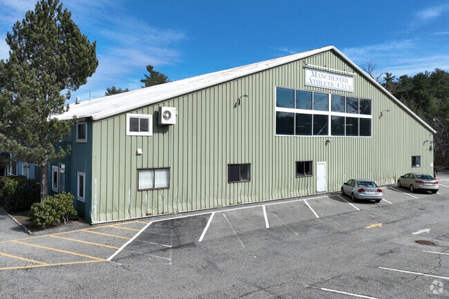
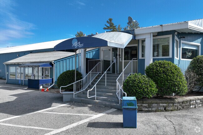
Property Record
8 Atwater Ave, Manchester, MA 01944

NEARBY LISTINGS FOR SALE OR LEASE
Property Detail
8 Atwater Ave
MANC-000038-000000-000013
Essex
Clubslodgesprofessionalassociations
Massachusetts
X
13
25009C0434H
6.36 AC
2025
Essex/Gloucester
2025
Boston
218100
Boston-Cambridge-Newton, MA-NH
86,343 SF
DEMOGRAPHICS near 8 Atwater Ave
1 Mile
3 Mile
5 Mile
2024 Total Population
1,784
11,149
32,958
2029 Population
1,799
11,131
32,898
Pop Growth 2024-2029
+ 0.84%
(0.16%)
(0.18%)
Average Age
44
45
43
2024 Total Households
695
4,502
12,219
HH Growth 2024-2029
+ 0.72%
(0.27%)
(0.26%)
Median Household Inc
$201,143
$150,040
$114,222
Avg Household Size
2.60
2.40
2.40
2024 Avg HH Vehicles
2.00
2.00
2.00
Median Home Value
$842,212
$800,370
$718,200
Median Year Built
1959
1962
1963
Nearby Places
Map Layers
Map Styles
 Street
 Aerial
- Restaurants
- Banks
- Shops
- Fitness
- Groceries
PUBLIC TRANSPORTATION
COMMUTER RAIL
Manchester (Newburyport/Rockport Line - Massachusetts Bay Transportation Authority Commuter Rail (Purple Line))
DRIVE
WALK
Distance
Manchester (Newburyport/Rockport Line - Massachusetts Bay Transportation Authority Commuter Rail (Purple Line))
6 min
2.1 mi
West Gloucester (Newburyport/Rockport Line - Massachusetts Bay Transportation Authority Commuter Rail (Purple Line))
DRIVE
WALK
Distance
West Gloucester (Newburyport/Rockport Line - Massachusetts Bay Transportation Authority Commuter Rail (Purple Line))
9 min
5.2 mi
AIRPORT
General Edward Lawrence Logan International
DRIVE
WALK
Distance
General Edward Lawrence Logan International
45 min
25.2 mi
Freight Ports
Port of Boston
DRIVE
WALK
Distance
Port of Boston
50 min
32.2 mi
Nearby Properties
Address
Land Use
TOTAL SIZE
Lot Size
Zoning
Address
Land Use
TOTAL SIZE
Lot Size
Zoning
184,976 SF
7.13 AC
A
Address
Land Use
TOTAL SIZE
Lot Size
Zoning
10,464 SF
237.02 AC
Address
Land Use
TOTAL SIZE
Lot Size
Zoning
180.40 AC
A
Address
Land Use
TOTAL SIZE
Lot Size
Zoning
91,450 SF
11.31 AC
G
Address
Land Use
TOTAL SIZE
Lot Size
Zoning
15,923 SF
7.44 AC
E
Address
Land Use
TOTAL SIZE
Lot Size
Zoning
99,412 SF
5.55 AC
C
Address
Land Use
TOTAL SIZE
Lot Size
Zoning
2.61 AC
E
Address
Land Use
TOTAL SIZE
Lot Size
Zoning
4.02 AC
E
Address
Land Use
TOTAL SIZE
Lot Size
Zoning
7,801 SF
2.76 AC
E
Address
Land Use
TOTAL SIZE
Lot Size
Zoning
8.67 AC
C
Address
Land Use
TOTAL SIZE
Lot Size
Zoning
144 SF
179.50 AC
RA
Address
Land Use
TOTAL SIZE
Lot Size
Zoning
1.69 AC
E
Address
Land Use
TOTAL SIZE
Lot Size
Zoning
1.34 AC
E
Address
Land Use
TOTAL SIZE
Lot Size
Zoning
1.80 AC
E
Address
Land Use
TOTAL SIZE
Lot Size
Zoning
6.48 AC
E
Address
Land Use
TOTAL SIZE
Lot Size
Zoning
7,040 SF
2.80 AC
E
Address
Land Use
TOTAL SIZE
Lot Size
Zoning
2.28 AC
E
Address
Land Use
TOTAL SIZE
Lot Size
Zoning
2.96 AC
E
Address
Land Use
TOTAL SIZE
Lot Size
Zoning
41.14 AC
LCD
Address
Land Use
TOTAL SIZE
Lot Size
Zoning
12.20 AC
E
Address
Land Use
TOTAL SIZE
Lot Size
Zoning
2.07 AC
E
Address
Land Use
TOTAL SIZE
Lot Size
Zoning
23.96 AC
E
Address
Land Use
TOTAL SIZE
Lot Size
Zoning
7,879 SF
2.95 AC
E
Address
Land Use
TOTAL SIZE
Lot Size
Zoning
2,718 SF
1.29 AC
E
Address
Land Use
TOTAL SIZE
Lot Size
Zoning
0.72 AC
E
Address
Land Use
TOTAL SIZE
Lot Size
Zoning
2,632 SF
5.16 AC
E
Address
Land Use
TOTAL SIZE
Lot Size
Zoning
684 SF
1.18 AC
E
Address
Land Use
TOTAL SIZE
Lot Size
Zoning
4,938 SF
3.50 AC
E
Address
Land Use
TOTAL SIZE
Lot Size
Zoning
2.07 AC
E
The World's #1 Commercial Real Estate Marketplace
Connect with us
© 2025 CoStar Group
The information above has been obtained from sources believed reliable. While we do not doubt its accuracy we have not verified it and make no guarantee, warranty or representation about it. It is your responsibility to independently confirm its accuracy and completeness. Any projections, opinions, assumptions, or estimates used are for example only and do not represent the current or future performance of the property. The value of this transaction to you depends on tax and other factors which should be evaluated by your tax, financial, and legal advisors. You and your advisors should conduct a careful, independent investigation of the property to determine to your satisfaction the suitability of the property for your needs.