Property Record
8 Biesecker Rd, Lexington, NC 27295
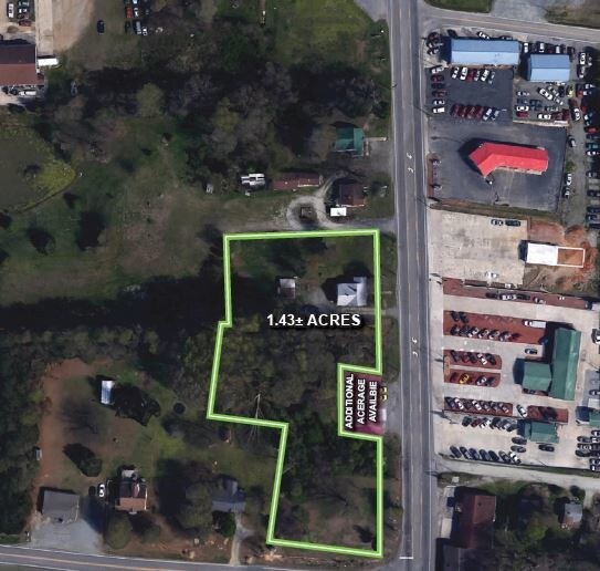

Property Detail
8 Biesecker Rd
Publicstorage
P=5-59 BB L5 BK2657-2172
RC
Davidson
B and X Area of moderate flood hazard, usually the area between the limits of the 100-year and 500-year floods.
North Carolina
2025
South Davidson County
2025
Greensboro/Winston-Salem
061204
Winston-Salem, NC
12,959 SF
11-332-D-00B-0005-0-0-0
NEARBY LISTINGS FOR SALE OR LEASE
DEMOGRAPHICS near 8 Biesecker Rd
1 mile
3 mile
5 mile
2025 Total Population
4,615
24,985
44,080
2030 Population
4,908
26,531
46,585
Pop Growth 2025-2030
+ 6.35%
+ 6.19%
+ 5.68%
Average Age
41
40
41
2025 Total Households
1,878
10,040
17,836
HH Growth 2025-2030
+ 6.50%
+ 6.32%
+ 5.79%
Median Household Inc
$43,771
$46,452
$58,295
Avg Household Size
2.40
2.40
2.40
2025 Avg HH Vehicles
2.00
2.00
2.00
Median Home Value
$164,334
$182,999
$199,129
Median Year Built
1976
1976
1979
Nearby Places
Map Layers
Map Styles
 Street
 Aerial
Transit
 Traffic
 Biking
Places
Listings with unknown addresses are not visible on the map
- Restaurants
- Banks
- Shops
- Fitness
- Groceries
PUBLIC TRANSPORTATION
AIRPORT
Piedmont Triad International
Drive
Walk
Distance
Piedmont Triad International
49 min
35.8 mi
Freight Ports
Port of Wilmington
Drive
Walk
Distance
Port of Wilmington
258 min
214.1 mi
SALE & LEASE HISTORY
LISTING DATE
SALE/LEASE

May 31, 2017
For Sale
Jan 11, 2019
For Sale
Nearby Properties
Address
Land Use
TOTAL SIZE
Lot Size
Zoning
Address
Land Use
TOTAL SIZE
Lot Size
Zoning
1,444 SF
19.95 AC
RA1
Address
Land Use
TOTAL SIZE
Lot Size
Zoning
2,736 SF
4.77 AC
U
Address
Land Use
TOTAL SIZE
Lot Size
Zoning
32,834 SF
30 AC
RA3
Address
Land Use
TOTAL SIZE
Lot Size
Zoning
28,176 SF
16.01 AC
B
Address
Land Use
TOTAL SIZE
Lot Size
Zoning
20,651 SF
12.03 AC
B
Address
Land Use
TOTAL SIZE
Lot Size
Zoning
33,282 SF
4.41 AC
B
Address
Land Use
TOTAL SIZE
Lot Size
Zoning
40,047 SF
8.75 AC
B
Address
Land Use
TOTAL SIZE
Lot Size
Zoning
8,008 SF
9.26 AC
TN
Address
Land Use
TOTAL SIZE
Lot Size
Zoning
63,794 SF
2.84 AC
B
Address
Land Use
TOTAL SIZE
Lot Size
Zoning
85,425 SF
1.16 AC
U
Address
Land Use
TOTAL SIZE
Lot Size
Zoning
115,748 SF
8.14 AC
B
Address
Land Use
TOTAL SIZE
Lot Size
Zoning
128 SF
107.80 AC
PD
Address
Land Use
TOTAL SIZE
Lot Size
Zoning
115,600 SF
13.15 AC
I
Address
Land Use
TOTAL SIZE
Lot Size
Zoning
95,953 SF
1.42 AC
U
Address
Land Use
TOTAL SIZE
Lot Size
Zoning
8,248 SF
10.29 AC
TN
Address
Land Use
TOTAL SIZE
Lot Size
Zoning
42,132 SF
6.33 AC
B
Address
Land Use
TOTAL SIZE
Lot Size
Zoning
2,414 SF
16.14 AC
TN
Address
Land Use
TOTAL SIZE
Lot Size
Zoning
91,758 SF
12.07 AC
B
Address
Land Use
TOTAL SIZE
Lot Size
Zoning
2,148 SF
6.62 AC
TN
Address
Land Use
TOTAL SIZE
Lot Size
Zoning
18,986 SF
6.79 AC
TN
Address
Land Use
TOTAL SIZE
Lot Size
Zoning
135,603 SF
3.76 AC
TN
Address
Land Use
TOTAL SIZE
Lot Size
Zoning
10,396 SF
11.70 AC
B
Address
Land Use
TOTAL SIZE
Lot Size
Zoning
60,944 SF
10.70 AC
B
Address
Land Use
TOTAL SIZE
Lot Size
Zoning
9,054 SF
24.77 AC
TN
Address
Land Use
TOTAL SIZE
Lot Size
Zoning
48,564 SF
24.75 AC
TN
Address
Land Use
TOTAL SIZE
Lot Size
Zoning
36,014 SF
0.73 AC
U
Address
Land Use
TOTAL SIZE
Lot Size
Zoning
35,396 SF
10.31 AC
I
Address
Land Use
TOTAL SIZE
Lot Size
Zoning
9,248 SF
14.71 AC
RM2
Address
Land Use
TOTAL SIZE
Lot Size
Zoning
3,224 SF
2.10 AC
DD
Address
Land Use
TOTAL SIZE
Lot Size
Zoning
14,551 SF
10.81 AC
RA3
The World's #1 Commercial Real Estate Marketplace
Connect with us
© 2026 CoStar Group
The information above has been obtained from sources believed reliable. While we do not doubt its accuracy we have not verified it and make no guarantee, warranty or representation about it. It is your responsibility to independently confirm its accuracy and completeness. Any projections, opinions, assumptions, or estimates used are for example only and do not represent the current or future performance of the property. The value of this transaction to you depends on tax and other factors which should be evaluated by your tax, financial, and legal advisors. You and your advisors should conduct a careful, independent investigation of the property to determine to your satisfaction the suitability of the property for your needs.