Property Record
950 Hopkins Ave, Glenolden, PA 19036
Current Lease Availabilities
NEARBY LISTINGS FOR SALE OR LEASE
Property Detail
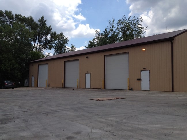
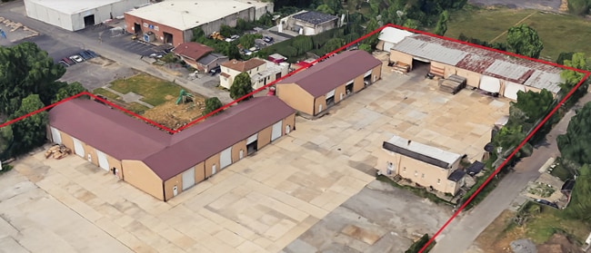
950 Hopkins Ave
15-00-01762-00
2 STY HSE 42 X 101
Commercialacreage
Delaware
X
Pennsylvania
42045C0116F
0.97 AC
2024
Delaware County
2025
Philadelphia
403502
Philadelphia-Camden-Wilmington, PA-NJ-DE-MD
DEMOGRAPHICS near 950 Hopkins Ave
1 Mile
3 Mile
5 Mile
2024 Total Population
26,598
193,733
459,011
2029 Population
26,303
190,675
450,795
Pop Growth 2024-2029
(1.11%)
(1.58%)
(1.79%)
Average Age
39
39
39
2024 Total Households
10,457
75,014
174,918
HH Growth 2024-2029
(1.14%)
(1.64%)
(1.92%)
Median Household Inc
$60,176
$66,547
$59,573
Avg Household Size
2.50
2.50
2.50
2024 Avg HH Vehicles
2.00
2.00
1.00
Median Home Value
$157,471
$188,947
$194,188
Median Year Built
1954
1953
1949
Nearby Places
Map Layers
Map Styles
 Street
 Aerial
- Restaurants
- Banks
- Shops
- Fitness
- Groceries
PUBLIC TRANSPORTATION
TRANSIT/SUBWAY
Bartram Avenue (Route 102 - SEPTA)
DRIVE
WALK
Distance
Bartram Avenue (Route 102 - SEPTA)
3 min
13 min
0.7 mi
Macdade Boulevard (Route 102 - SEPTA)
DRIVE
WALK
Distance
Macdade Boulevard (Route 102 - SEPTA)
2 min
14 min
0.8 mi
North Street (Route 102 - SEPTA)
DRIVE
WALK
Distance
North Street (Route 102 - SEPTA)
3 min
15 min
0.8 mi
Andrews Avenue (Route 102 - SEPTA)
DRIVE
WALK
Distance
Andrews Avenue (Route 102 - SEPTA)
3 min
16 min
0.9 mi
Magnolia Avenue (Route 102 - SEPTA)
DRIVE
WALK
Distance
Magnolia Avenue (Route 102 - SEPTA)
3 min
18 min
0.9 mi
COMMUTER RAIL
Primos (R3 - Southeastern Pennsylvania Transportation Authority Regional Rail (SEPTA Regional Rail))
DRIVE
WALK
Distance
Primos (R3 - Southeastern Pennsylvania Transportation Authority Regional Rail (SEPTA Regional Rail))
2 min
19 min
1.0 mi
Folcroft (R2 - Southeastern Pennsylvania Transportation Authority Regional Rail (SEPTA Regional Rail))
DRIVE
WALK
Distance
Folcroft (R2 - Southeastern Pennsylvania Transportation Authority Regional Rail (SEPTA Regional Rail))
3 min
1.2 mi
AIRPORT
Philadelphia International
DRIVE
WALK
Distance
Philadelphia International
14 min
6.2 mi
Freight Ports
South Jersey Port
DRIVE
WALK
Distance
South Jersey Port
29 min
14.5 mi
Nearby Properties
Address
Land Use
TOTAL SIZE
Lot Size
Zoning
Address
Land Use
TOTAL SIZE
Lot Size
Zoning
762,100 SF
Address
Land Use
TOTAL SIZE
Lot Size
Zoning
910,000 SF
70 AC
I2
Address
Land Use
TOTAL SIZE
Lot Size
Zoning
488,254 SF
31.56 AC
I2
Address
Land Use
TOTAL SIZE
Lot Size
Zoning
97,810 SF
40 AC
I3
Address
Land Use
TOTAL SIZE
Lot Size
Zoning
175,978 SF
15.95 AC
Address
Land Use
TOTAL SIZE
Lot Size
Zoning
15,660 SF
56.60 AC
Address
Land Use
TOTAL SIZE
Lot Size
Zoning
164,182 SF
Address
Land Use
TOTAL SIZE
Lot Size
Zoning
323,248 SF
2.90 AC
SPAIR
Address
Land Use
TOTAL SIZE
Lot Size
Zoning
975.62 AC
Address
Land Use
TOTAL SIZE
Lot Size
Zoning
140,010 SF
28.50 AC
ICMX
Address
Land Use
TOTAL SIZE
Lot Size
Zoning
63.81 AC
I2
Address
Land Use
TOTAL SIZE
Lot Size
Zoning
20,880 SF
27.20 AC
Address
Land Use
TOTAL SIZE
Lot Size
Zoning
6,040 SF
16.45 AC
Address
Land Use
TOTAL SIZE
Lot Size
Zoning
63.53 AC
CMX3
Address
Land Use
TOTAL SIZE
Lot Size
Zoning
156,079 SF
13.44 AC
Address
Land Use
TOTAL SIZE
Lot Size
Zoning
25,680 SF
31.64 AC
Address
Land Use
TOTAL SIZE
Lot Size
Zoning
136,972 SF
27 AC
Address
Land Use
TOTAL SIZE
Lot Size
Zoning
3,600 SF
6.61 AC
SPPOA
Address
Land Use
TOTAL SIZE
Lot Size
Zoning
255,316 SF
6 AC
Address
Land Use
TOTAL SIZE
Lot Size
Zoning
96,500 SF
6.11 AC
CMX3
Address
Land Use
TOTAL SIZE
Lot Size
Zoning
16,990 SF
221.09 AC
SPPOA
Address
Land Use
TOTAL SIZE
Lot Size
Zoning
40,572 SF
6.52 AC
Address
Land Use
TOTAL SIZE
Lot Size
Zoning
246,296 SF
10.78 AC
RM2
Address
Land Use
TOTAL SIZE
Lot Size
Zoning
246,303 SF
11 AC
RM2
Address
Land Use
TOTAL SIZE
Lot Size
Zoning
68,096 SF
7.78 AC
Address
Land Use
TOTAL SIZE
Lot Size
Zoning
282,520 SF
24.44 AC
Address
Land Use
TOTAL SIZE
Lot Size
Zoning
160,959 SF
7.97 AC
RM2
Address
Land Use
TOTAL SIZE
Lot Size
Zoning
86,052 SF
7.63 AC
Address
Land Use
TOTAL SIZE
Lot Size
Zoning
107,530 SF
Address
Land Use
TOTAL SIZE
Lot Size
Zoning
187,056 SF
16 AC
The World's #1 Commercial Real Estate Marketplace
Connect with us
© 2025 CoStar Group
The information above has been obtained from sources believed reliable. While we do not doubt its accuracy we have not verified it and make no guarantee, warranty or representation about it. It is your responsibility to independently confirm its accuracy and completeness. Any projections, opinions, assumptions, or estimates used are for example only and do not represent the current or future performance of the property. The value of this transaction to you depends on tax and other factors which should be evaluated by your tax, financial, and legal advisors. You and your advisors should conduct a careful, independent investigation of the property to determine to your satisfaction the suitability of the property for your needs.