Property Record
8 Halstead Ave, Wallington, NJ 07057
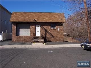

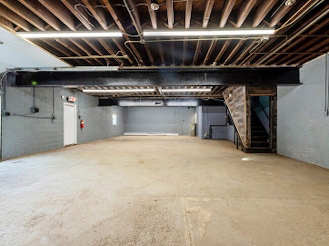
Property Detail
8 Halstead Ave
New York-Jersey City-White Plains, NY-NJ
.169 AC
65-00007-0000-00030
Bergen
Industrialgeneral
New Jersey
LI
30
AE The base floodplain where base flood elevations are provided. AE Zones are now used on new format FIRMs instead of A1-A30 Zones.
0.17 AC
2024
Teterboro Airport
2025
Northern New Jersey
057200
NEARBY LISTINGS FOR SALE OR LEASE
DEMOGRAPHICS near 8 Halstead Ave
1 mile
3 mile
5 mile
2025 Total Population
58,009
281,867
639,172
2030 Population
58,816
284,869
650,326
Pop Growth 2025-2030
+ 1.39%
+ 1.07%
+ 1.75%
Average Age
36
39
40
2025 Total Households
18,651
98,761
227,547
HH Growth 2025-2030
+ 1.25%
+ 1.07%
+ 1.85%
Median Household Inc
$57,343
$84,910
$89,792
Avg Household Size
3.00
2.80
2.70
2025 Avg HH Vehicles
1.00
2.00
2.00
Median Home Value
$455,580
$483,042
$477,967
Median Year Built
1949
1952
1954
Nearby Places
Map Layers
Map Styles
 Street
 Aerial
Transit
 Traffic
 Biking
Places
Listings with unknown addresses are not visible on the map
- Restaurants
- Banks
- Shops
- Fitness
- Groceries
PUBLIC TRANSPORTATION
COMMUTER RAIL
Garfield (Bergen County/Port Jervis Line - NJ Transit Commuter Rail (NJ Transit))
Drive
Walk
Distance
Garfield (Bergen County/Port Jervis Line - NJ Transit Commuter Rail (NJ Transit))
4 min
1.2 mi
Passaic (Main/Port Jervis Line - NJ Transit Commuter Rail (NJ Transit))
Drive
Walk
Distance
Passaic (Main/Port Jervis Line - NJ Transit Commuter Rail (NJ Transit))
5 min
1.8 mi
AIRPORT
Newark Liberty International
Drive
Walk
Distance
Newark Liberty International
20 min
15.4 mi
LaGuardia
Drive
Walk
Distance
LaGuardia
38 min
23.7 mi
John F Kennedy International
Drive
Walk
Distance
John F Kennedy International
49 min
29.3 mi
Freight Ports
Maher Terminal
Drive
Walk
Distance
Maher Terminal
27 min
16.2 mi
SALE & LEASE HISTORY
LISTING DATE
SALE/LEASE

Jun 08, 2023
For Sale
Feb 16, 2023
For Lease
Apr 22, 2022
For Sale
Nearby Properties
Address
Land Use
TOTAL SIZE
Lot Size
Zoning
Address
Land Use
TOTAL SIZE
Lot Size
Zoning
Address
Land Use
TOTAL SIZE
Lot Size
Zoning
4,014 SF
21 AC
Address
Land Use
TOTAL SIZE
Lot Size
Zoning
612 AC
SEA
Address
Land Use
TOTAL SIZE
Lot Size
Zoning
335.71 AC
AF
Address
Land Use
TOTAL SIZE
Lot Size
Zoning
Address
Land Use
TOTAL SIZE
Lot Size
Zoning
9.57 AC
I2
Address
Land Use
TOTAL SIZE
Lot Size
Zoning
7.10 AC
R-3
Address
Land Use
TOTAL SIZE
Lot Size
Zoning
Address
Land Use
TOTAL SIZE
Lot Size
Zoning
30.46 AC
I
Address
Land Use
TOTAL SIZE
Lot Size
Zoning
1.12 AC
M-O
Address
Land Use
TOTAL SIZE
Lot Size
Zoning
7.29 AC
Address
Land Use
TOTAL SIZE
Lot Size
Zoning
Address
Land Use
TOTAL SIZE
Lot Size
Zoning
18.30 AC
Address
Land Use
TOTAL SIZE
Lot Size
Zoning
138,764 SF
1.47 AC
LM
Address
Land Use
TOTAL SIZE
Lot Size
Zoning
25.50 AC
B2
Address
Land Use
TOTAL SIZE
Lot Size
Zoning
26,816 SF
25.50 AC
POP
Address
Land Use
TOTAL SIZE
Lot Size
Zoning
24.29 AC
Address
Land Use
TOTAL SIZE
Lot Size
Zoning
82.74 AC
Address
Land Use
TOTAL SIZE
Lot Size
Zoning
16.94 AC
R2
Address
Land Use
TOTAL SIZE
Lot Size
Zoning
24.35 AC
Address
Land Use
TOTAL SIZE
Lot Size
Zoning
13.80 AC
Address
Land Use
TOTAL SIZE
Lot Size
Zoning
11.30 AC
Address
Land Use
TOTAL SIZE
Lot Size
Zoning
148,918 SF
4.17 AC
B
Address
Land Use
TOTAL SIZE
Lot Size
Zoning
Address
Land Use
TOTAL SIZE
Lot Size
Zoning
13.36 AC
Address
Land Use
TOTAL SIZE
Lot Size
Zoning
136,148 SF
12.81 AC
Address
Land Use
TOTAL SIZE
Lot Size
Zoning
177,672 SF
7.51 AC
IA
Address
Land Use
TOTAL SIZE
Lot Size
Zoning
0.99 AC
Address
Land Use
TOTAL SIZE
Lot Size
Zoning
7.22 AC
M-3
Address
Land Use
TOTAL SIZE
Lot Size
Zoning
31.63 AC
I
The World's #1 Commercial Real Estate Marketplace
Connect with us
© 2026 CoStar Group
The information above has been obtained from sources believed reliable. While we do not doubt its accuracy we have not verified it and make no guarantee, warranty or representation about it. It is your responsibility to independently confirm its accuracy and completeness. Any projections, opinions, assumptions, or estimates used are for example only and do not represent the current or future performance of the property. The value of this transaction to you depends on tax and other factors which should be evaluated by your tax, financial, and legal advisors. You and your advisors should conduct a careful, independent investigation of the property to determine to your satisfaction the suitability of the property for your needs.