Property Record
8 Harriet Hts, Monroe, NY 10950
Property Detail
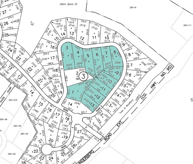
8 Harriet Hts
Kiryas Joel-Poughkeepsie-Newburgh, NY
ORANGE
335809-254-000-0003-003.000-0000
New York
Residentialacreage
17.00
B and X Area of moderate flood hazard, usually the area between the limits of the 100-year and 500-year floods.
0.83 AC
2024
Newburgh
2024
Northern New Jersey
014101
NEARBY LISTINGS FOR SALE OR LEASE
DEMOGRAPHICS near 8 Harriet Hts
1 mile
3 mile
5 mile
2025 Total Population
3,309
62,223
79,936
2030 Population
3,430
64,122
82,368
Pop Growth 2025-2030
+ 3.66%
+ 3.05%
+ 3.04%
Average Age
35
29
31
2025 Total Households
966
14,951
20,548
HH Growth 2025-2030
+ 3.31%
+ 3.16%
+ 3.15%
Median Household Inc
$127,419
$76,890
$86,322
Avg Household Size
3.30
4.00
3.70
2025 Avg HH Vehicles
2.00
1.00
2.00
Median Home Value
$538,934
$520,485
$491,281
Median Year Built
1985
1993
1987
Nearby Places
Map Layers
Map Styles
 Street
 Aerial
Transit
 Traffic
 Biking
Places
Listings with unknown addresses are not visible on the map
- Restaurants
- Banks
- Shops
- Fitness
- Groceries
PUBLIC TRANSPORTATION
COMMUTER RAIL
Harriman (Bergen County/Port Jervis Line - NJ Transit Commuter Rail (NJ Transit), Main/Port Jervis Line - NJ Transit Commuter Rail (NJ Transit))
Drive
Walk
Distance
Harriman (Bergen County/Port Jervis Line - NJ Transit Commuter Rail (NJ Transit), Main/Port Jervis Line - NJ Transit Commuter Rail (NJ Transit))
11 min
4.0 mi
AIRPORT
New York Stewart International
Drive
Walk
Distance
New York Stewart International
35 min
18.0 mi
Westchester County
Drive
Walk
Distance
Westchester County
65 min
46.4 mi
Freight Ports
Port Newark Container Terminal
Drive
Walk
Distance
Port Newark Container Terminal
77 min
53.7 mi
Nearby Properties
Address
Land Use
TOTAL SIZE
Lot Size
Zoning
Address
Land Use
TOTAL SIZE
Lot Size
Zoning
143.60 AC
LIO
Address
Land Use
TOTAL SIZE
Lot Size
Zoning
114.40 AC
Address
Land Use
TOTAL SIZE
Lot Size
Zoning
12 AC
Address
Land Use
TOTAL SIZE
Lot Size
Zoning
235,455 SF
51.70 AC
IB
Address
Land Use
TOTAL SIZE
Lot Size
Zoning
103,290 SF
41.22 AC
RR-1.0AC
Address
Land Use
TOTAL SIZE
Lot Size
Zoning
125,636 SF
19.91 AC
SR-20
Address
Land Use
TOTAL SIZE
Lot Size
Zoning
Address
Land Use
TOTAL SIZE
Lot Size
Zoning
7.30 AC
LIO
Address
Land Use
TOTAL SIZE
Lot Size
Zoning
31,507 SF
10.50 AC
UR-M
Address
Land Use
TOTAL SIZE
Lot Size
Zoning
7.50 AC
RQTRA
Address
Land Use
TOTAL SIZE
Lot Size
Zoning
4.50 AC
Address
Land Use
TOTAL SIZE
Lot Size
Zoning
15.90 AC
Address
Land Use
TOTAL SIZE
Lot Size
Zoning
6.90 AC
Address
Land Use
TOTAL SIZE
Lot Size
Zoning
23,534 SF
6.60 AC
PD
Address
Land Use
TOTAL SIZE
Lot Size
Zoning
39,235 SF
6.40 AC
Address
Land Use
TOTAL SIZE
Lot Size
Zoning
Address
Land Use
TOTAL SIZE
Lot Size
Zoning
124,928 SF
12.14 AC
GB
Address
Land Use
TOTAL SIZE
Lot Size
Zoning
70,760 SF
17.20 AC
GB
Address
Land Use
TOTAL SIZE
Lot Size
Zoning
91,472 SF
6.42 AC
SR-10
Address
Land Use
TOTAL SIZE
Lot Size
Zoning
88,240 SF
3.02 AC
R-1
Address
Land Use
TOTAL SIZE
Lot Size
Zoning
113,910 SF
15 AC
PD
Address
Land Use
TOTAL SIZE
Lot Size
Zoning
159,857 SF
24.59 AC
LI
Address
Land Use
TOTAL SIZE
Lot Size
Zoning
Address
Land Use
TOTAL SIZE
Lot Size
Zoning
103,908 SF
7.40 AC
I
Address
Land Use
TOTAL SIZE
Lot Size
Zoning
9.60 AC
IB
Address
Land Use
TOTAL SIZE
Lot Size
Zoning
92,868 SF
1.22 AC
PD
Address
Land Use
TOTAL SIZE
Lot Size
Zoning
88,855 SF
5 AC
PD
Address
Land Use
TOTAL SIZE
Lot Size
Zoning
7.60 AC
Address
Land Use
TOTAL SIZE
Lot Size
Zoning
5.20 AC
IB
Address
Land Use
TOTAL SIZE
Lot Size
Zoning
126,112 SF
3.30 AC
R-1
The World's #1 Commercial Real Estate Marketplace
Connect with us
© 2026 CoStar Group
The information above has been obtained from sources believed reliable. While we do not doubt its accuracy we have not verified it and make no guarantee, warranty or representation about it. It is your responsibility to independently confirm its accuracy and completeness. Any projections, opinions, assumptions, or estimates used are for example only and do not represent the current or future performance of the property. The value of this transaction to you depends on tax and other factors which should be evaluated by your tax, financial, and legal advisors. You and your advisors should conduct a careful, independent investigation of the property to determine to your satisfaction the suitability of the property for your needs.