Property Record
8 High St, Glouster, OH 45732
Property Detail
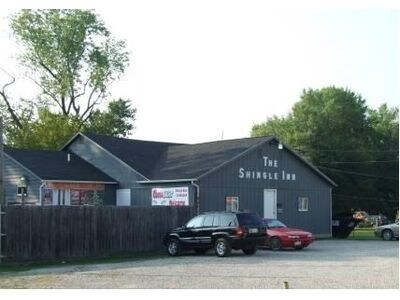
8 High St
M04-00700030-00
IL 491 PP H-4
Bartavern
Athens
AE The base floodplain where base flood elevations are provided. AE Zones are now used on new format FIRMs instead of A1-A30 Zones.
Ohio
2025
0.17 AC
2025
Ohio South Area
972600
Other Market Areas
3,388 SF
Athens, OH
NEARBY LISTINGS FOR SALE OR LEASE
-
-
View all Glouster listings for sale on LoopNet.com
DEMOGRAPHICS near 8 High St
1 mile
3 mile
5 mile
2025 Total Population
2,158
4,353
6,119
2030 Population
2,218
4,409
6,161
Pop Growth 2025-2030
+ 2.78%
+ 1.29%
+ 0.69%
Average Age
40
41
42
2025 Total Households
836
1,746
2,477
HH Growth 2025-2030
+ 2.87%
+ 1.37%
+ 0.81%
Median Household Inc
$42,187
$47,061
$51,240
Avg Household Size
2.50
2.40
2.40
2025 Avg HH Vehicles
2.00
2.00
2.00
Median Home Value
$79,066
$83,333
$96,517
Median Year Built
1957
1962
1970
Nearby Places
Map Layers
Map Styles
 Street
 Aerial
Transit
 Traffic
 Biking
Places
Listings with unknown addresses are not visible on the map
- Restaurants
- Banks
- Shops
- Fitness
- Groceries
Nearby Properties
Address
Land Use
TOTAL SIZE
Lot Size
Zoning
Address
Land Use
TOTAL SIZE
Lot Size
Zoning
11,130 SF
6.55 AC
Address
Land Use
TOTAL SIZE
Lot Size
Zoning
82,386 SF
21.76 AC
Address
Land Use
TOTAL SIZE
Lot Size
Zoning
71,646 SF
25.32 AC
Address
Land Use
TOTAL SIZE
Lot Size
Zoning
1,728 SF
42.62 AC
Address
Land Use
TOTAL SIZE
Lot Size
Zoning
0.99 AC
Address
Land Use
TOTAL SIZE
Lot Size
Zoning
27,590 SF
14.02 AC
Address
Land Use
TOTAL SIZE
Lot Size
Zoning
340 SF
3.14 AC
Address
Land Use
TOTAL SIZE
Lot Size
Zoning
10,640 SF
1.14 AC
Address
Land Use
TOTAL SIZE
Lot Size
Zoning
600 SF
262.94 AC
Address
Land Use
TOTAL SIZE
Lot Size
Zoning
3,960 SF
8 AC
Address
Land Use
TOTAL SIZE
Lot Size
Zoning
7,200 SF
1.03 AC
Address
Land Use
TOTAL SIZE
Lot Size
Zoning
280.50 AC
Address
Land Use
TOTAL SIZE
Lot Size
Zoning
4,158 SF
5.81 AC
Address
Land Use
TOTAL SIZE
Lot Size
Zoning
273.16 AC
Address
Land Use
TOTAL SIZE
Lot Size
Zoning
255.96 AC
Address
Land Use
TOTAL SIZE
Lot Size
Zoning
3,233 SF
42.84 AC
Address
Land Use
TOTAL SIZE
Lot Size
Zoning
15,496 SF
4.62 AC
Address
Land Use
TOTAL SIZE
Lot Size
Zoning
2,272 SF
122.39 AC
Address
Land Use
TOTAL SIZE
Lot Size
Zoning
672 SF
125.50 AC
Address
Land Use
TOTAL SIZE
Lot Size
Zoning
1,400 SF
90.31 AC
Address
Land Use
TOTAL SIZE
Lot Size
Zoning
9,060 SF
0.15 AC
Address
Land Use
TOTAL SIZE
Lot Size
Zoning
1,008 SF
55.79 AC
Address
Land Use
TOTAL SIZE
Lot Size
Zoning
0.23 AC
Address
Land Use
TOTAL SIZE
Lot Size
Zoning
2,304 SF
43.73 AC
Address
Land Use
TOTAL SIZE
Lot Size
Zoning
1,680 SF
66.46 AC
Address
Land Use
TOTAL SIZE
Lot Size
Zoning
8,288 SF
0.12 AC
Address
Land Use
TOTAL SIZE
Lot Size
Zoning
232.20 AC
Address
Land Use
TOTAL SIZE
Lot Size
Zoning
2,664 SF
55.10 AC
Address
Land Use
TOTAL SIZE
Lot Size
Zoning
1,040 SF
40.28 AC
Address
Land Use
TOTAL SIZE
Lot Size
Zoning
2,520 SF
27.95 AC
The World's #1 Commercial Real Estate Marketplace
Connect with us
© 2026 CoStar Group
The information above has been obtained from sources believed reliable. While we do not doubt its accuracy we have not verified it and make no guarantee, warranty or representation about it. It is your responsibility to independently confirm its accuracy and completeness. Any projections, opinions, assumptions, or estimates used are for example only and do not represent the current or future performance of the property. The value of this transaction to you depends on tax and other factors which should be evaluated by your tax, financial, and legal advisors. You and your advisors should conduct a careful, independent investigation of the property to determine to your satisfaction the suitability of the property for your needs.