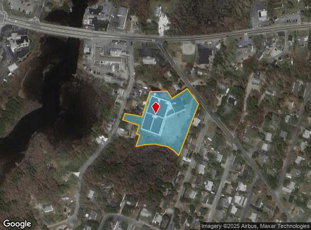
Property Record
17 Shad Hole Rd, Dennis Port, MA 02639
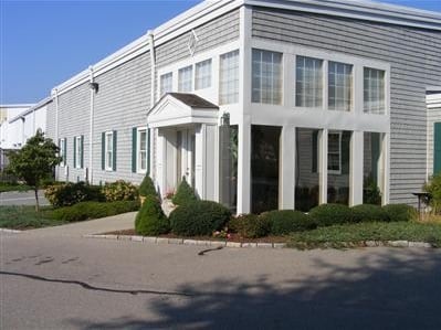
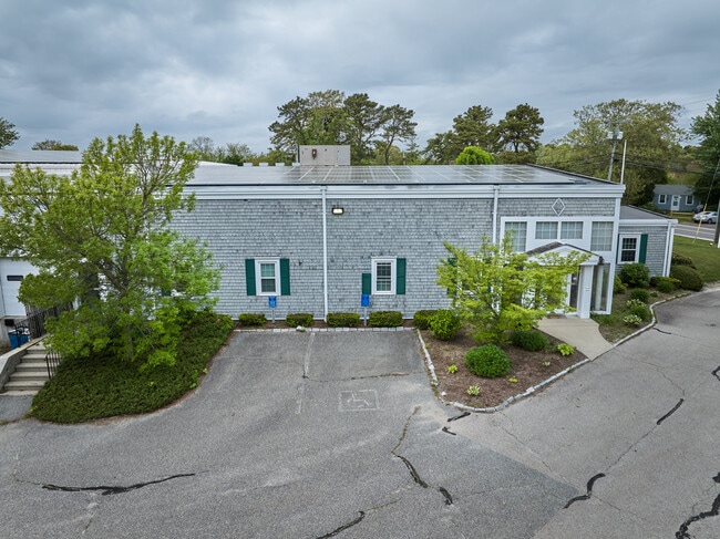
This Property Is For Sale
NEARBY LISTINGS FOR SALE OR LEASE
Property Detail
17 Shad Hole Rd
Taxexempt
Barnstable
AE
Massachusetts
25001C0592J
2.25 AC
2019
Cape Cod
2025
Other Market Areas
011600
Barnstable Town, MA
29,374 SF
DENN-000070-000000-000022
DEMOGRAPHICS near 17 Shad Hole Rd
1 Mile
3 Mile
5 Mile
2024 Total Population
3,947
17,511
45,092
2029 Population
4,177
18,402
47,129
Pop Growth 2024-2029
+ 5.83%
+ 5.09%
+ 4.52%
Average Age
51
52
51
2024 Total Households
2,112
8,522
21,462
HH Growth 2024-2029
+ 5.73%
+ 5.10%
+ 4.50%
Median Household Inc
$53,302
$68,784
$72,793
Avg Household Size
1.80
2.00
2.00
2024 Avg HH Vehicles
2.00
2.00
2.00
Median Home Value
$422,679
$457,756
$461,185
Median Year Built
1965
1968
1972
Nearby Places
- Restaurants
- Banks
- Shops
- Fitness
- Groceries
PUBLIC TRANSPORTATION
COMMUTER RAIL
DRIVE
WALK
Distance
15 min
7.7 mi
AIRPORT
Nantucket Memorial
DRIVE
WALK
Distance
Nantucket Memorial
164 min
41.2 mi
Martha's Vineyard
DRIVE
WALK
Distance
Martha's Vineyard
120 min
46.6 mi
Freight Ports
Port of New Bedford Harbor
DRIVE
WALK
Distance
Port of New Bedford Harbor
80 min
55.9 mi
Nearby Properties
Address
Land Use
TOTAL SIZE
Lot Size
Zoning
Address
Land Use
TOTAL SIZE
Lot Size
Zoning
221,710 SF
67.02 AC
Address
Land Use
TOTAL SIZE
Lot Size
Zoning
138,804 SF
15.94 AC
Address
Land Use
TOTAL SIZE
Lot Size
Zoning
Address
Land Use
TOTAL SIZE
Lot Size
Zoning
3.42 AC
Address
Land Use
TOTAL SIZE
Lot Size
Zoning
10.34 AC
Address
Land Use
TOTAL SIZE
Lot Size
Zoning
Address
Land Use
TOTAL SIZE
Lot Size
Zoning
Address
Land Use
TOTAL SIZE
Lot Size
Zoning
14,844 SF
0.50 AC
Address
Land Use
TOTAL SIZE
Lot Size
Zoning
Address
Land Use
TOTAL SIZE
Lot Size
Zoning
Address
Land Use
TOTAL SIZE
Lot Size
Zoning
59,054 SF
9.53 AC
R
Address
Land Use
TOTAL SIZE
Lot Size
Zoning
11,017 SF
5.52 AC
Address
Land Use
TOTAL SIZE
Lot Size
Zoning
1,793 SF
1.32 AC
Address
Land Use
TOTAL SIZE
Lot Size
Zoning
7,134 SF
1.45 AC
Address
Land Use
TOTAL SIZE
Lot Size
Zoning
7,172 SF
1.33 AC
Address
Land Use
TOTAL SIZE
Lot Size
Zoning
0.78 AC
R
Address
Land Use
TOTAL SIZE
Lot Size
Zoning
Address
Land Use
TOTAL SIZE
Lot Size
Zoning
6,276 SF
0.80 AC
R
Address
Land Use
TOTAL SIZE
Lot Size
Zoning
Address
Land Use
TOTAL SIZE
Lot Size
Zoning
0.80 AC
R
Address
Land Use
TOTAL SIZE
Lot Size
Zoning
2,942 SF
130.52 AC
Address
Land Use
TOTAL SIZE
Lot Size
Zoning
14.54 AC
Address
Land Use
TOTAL SIZE
Lot Size
Zoning
45.75 AC
R
Address
Land Use
TOTAL SIZE
Lot Size
Zoning
4,556 SF
1.10 AC
Address
Land Use
TOTAL SIZE
Lot Size
Zoning
38,518 SF
5.09 AC
Address
Land Use
TOTAL SIZE
Lot Size
Zoning
62,423 SF
13.98 AC
Address
Land Use
TOTAL SIZE
Lot Size
Zoning
0.66 AC
R
Address
Land Use
TOTAL SIZE
Lot Size
Zoning
3.17 AC
R
Address
Land Use
TOTAL SIZE
Lot Size
Zoning
0.51 AC
R
Address
Land Use
TOTAL SIZE
Lot Size
Zoning
0.74 AC
R
The World's #1 Commercial Real Estate Marketplace
Connect with us
© 2025 CoStar Group
The information above has been obtained from sources believed reliable. While we do not doubt its accuracy we have not verified it and make no guarantee, warranty or representation about it. It is your responsibility to independently confirm its accuracy and completeness. Any projections, opinions, assumptions, or estimates used are for example only and do not represent the current or future performance of the property. The value of this transaction to you depends on tax and other factors which should be evaluated by your tax, financial, and legal advisors. You and your advisors should conduct a careful, independent investigation of the property to determine to your satisfaction the suitability of the property for your needs.