Property Record
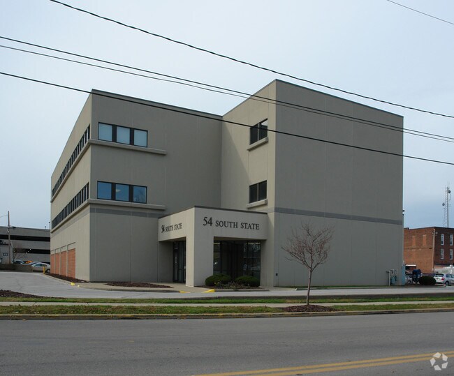
8 N State St, Painesville, OH 44077

NEARBY LISTINGS FOR SALE OR LEASE
Property Detail
8 N State St
15-A-012-A-00-004
PAINESVILLE LOT TRACT 3
Financialbuilding
Lake
X
Ohio
39085C0126F
0.17 AC
0
Northeast
2025
Cleveland
204400
Cleveland-Elyria, OH
35,422 SF
DEMOGRAPHICS near 8 N State St
1 Mile
3 Mile
5 Mile
2024 Total Population
9,788
41,168
72,471
2029 Population
9,770
41,189
72,259
Pop Growth 2024-2029
(0.18%)
+ 0.05%
(0.29%)
Average Age
37
40
42
2024 Total Households
3,711
16,480
29,248
HH Growth 2024-2029
(0.27%)
0.00%
(0.35%)
Median Household Inc
$43,667
$65,605
$78,967
Avg Household Size
2.40
2.40
2.40
2024 Avg HH Vehicles
2.00
2.00
2.00
Median Home Value
$118,265
$162,956
$195,050
Median Year Built
1957
1971
1976
Nearby Places
Map Layers
Map Styles
 Street
 Aerial
- Restaurants
- Banks
- Shops
- Fitness
- Groceries
Nearby Properties
Address
Land Use
TOTAL SIZE
Lot Size
Zoning
Address
Land Use
TOTAL SIZE
Lot Size
Zoning
160,976 SF
3.31 AC
B-4
Address
Land Use
TOTAL SIZE
Lot Size
Zoning
165,749 SF
8 AC
R-1
Address
Land Use
TOTAL SIZE
Lot Size
Zoning
243,207 SF
43.47 AC
R-3
Address
Land Use
TOTAL SIZE
Lot Size
Zoning
78,850 SF
Address
Land Use
TOTAL SIZE
Lot Size
Zoning
16,955 SF
69.10 AC
B3
Address
Land Use
TOTAL SIZE
Lot Size
Zoning
172,688 SF
26.82 AC
R-1
Address
Land Use
TOTAL SIZE
Lot Size
Zoning
113,375 SF
2.73 AC
B-3
Address
Land Use
TOTAL SIZE
Lot Size
Zoning
82,044 SF
8.79 AC
Address
Land Use
TOTAL SIZE
Lot Size
Zoning
144,410 SF
9.84 AC
Address
Land Use
TOTAL SIZE
Lot Size
Zoning
137,183 SF
12.35 AC
Address
Land Use
TOTAL SIZE
Lot Size
Zoning
198,832 SF
39.56 AC
Address
Land Use
TOTAL SIZE
Lot Size
Zoning
Address
Land Use
TOTAL SIZE
Lot Size
Zoning
57,744 SF
3.29 AC
Address
Land Use
TOTAL SIZE
Lot Size
Zoning
190,994 SF
24.91 AC
Address
Land Use
TOTAL SIZE
Lot Size
Zoning
59,448 SF
Address
Land Use
TOTAL SIZE
Lot Size
Zoning
402,462 SF
26.37 AC
I-2
Address
Land Use
TOTAL SIZE
Lot Size
Zoning
136,138 SF
15.25 AC
Address
Land Use
TOTAL SIZE
Lot Size
Zoning
51,672 SF
Address
Land Use
TOTAL SIZE
Lot Size
Zoning
42,089 SF
7.33 AC
Address
Land Use
TOTAL SIZE
Lot Size
Zoning
47,436 SF
16.83 AC
R1
Address
Land Use
TOTAL SIZE
Lot Size
Zoning
83,837 SF
9.43 AC
B-3
Address
Land Use
TOTAL SIZE
Lot Size
Zoning
178,252 SF
10.28 AC
B-3
Address
Land Use
TOTAL SIZE
Lot Size
Zoning
153,534 SF
36.47 AC
I2
Address
Land Use
TOTAL SIZE
Lot Size
Zoning
42,200 SF
2.83 AC
Address
Land Use
TOTAL SIZE
Lot Size
Zoning
51,576 SF
Address
Land Use
TOTAL SIZE
Lot Size
Zoning
78,810 SF
8.15 AC
R-1
Address
Land Use
TOTAL SIZE
Lot Size
Zoning
Address
Land Use
TOTAL SIZE
Lot Size
Zoning
74,502 SF
11.47 AC
R-1
Address
Land Use
TOTAL SIZE
Lot Size
Zoning
8,556 SF
74.61 AC
R-1
Address
Land Use
TOTAL SIZE
Lot Size
Zoning
74,502 SF
6.35 AC
R-1
The World's #1 Commercial Real Estate Marketplace
Connect with us
© 2026 CoStar Group
The information above has been obtained from sources believed reliable. While we do not doubt its accuracy we have not verified it and make no guarantee, warranty or representation about it. It is your responsibility to independently confirm its accuracy and completeness. Any projections, opinions, assumptions, or estimates used are for example only and do not represent the current or future performance of the property. The value of this transaction to you depends on tax and other factors which should be evaluated by your tax, financial, and legal advisors. You and your advisors should conduct a careful, independent investigation of the property to determine to your satisfaction the suitability of the property for your needs.