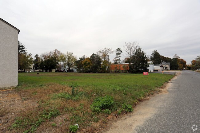
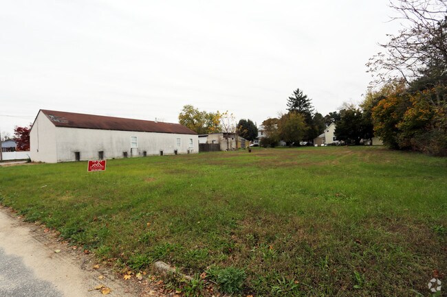
Property Record
8 Rena St, Newfield, NJ 08344

Save to a Folder
{{folder.Name}}
{{folder.ListingIds.length}} Properties
{{folder.ListingIds.length}} Property
Create a New Folder
Property Detail
8 Rena St
13-00206-0000-00010
GLOUCESTER
Vacantlandnec
New Jersey
C
10
B and X Area of moderate flood hazard, usually the area between the limits of the 100-year and 500-year floods.
0.39 AC
2025
Gloucester County
2026
Philadelphia
501800
Philadelphia-Camden-Wilmington, PA-NJ-DE-MD
NEARBY LISTINGS FOR SALE OR LEASE
DEMOGRAPHICS near 8 Rena St
1 mile
3 mile
5 mile
2025 Total Population
2,341
13,674
53,142
2030 Population
2,399
14,028
54,162
Pop Growth 2025-2030
+ 2.48%
+ 2.59%
+ 1.92%
Average Age
42
42
40
2025 Total Households
879
5,136
19,265
HH Growth 2025-2030
+ 2.50%
+ 2.57%
+ 1.92%
Median Household Inc
$93,487
$78,890
$69,697
Avg Household Size
2.70
2.60
2.70
2025 Avg HH Vehicles
2.00
2.00
2.00
Median Home Value
$252,589
$234,638
$234,637
Median Year Built
1972
1975
1968
Nearby Places
Map Layers
Map Styles
 Street
 Aerial
Layers
 Traffic
 Biking
Places
Listings with unknown addresses are not visible on the map
- Restaurants
- Banks
- Shops
- Fitness
- Groceries
PUBLIC TRANSPORTATION
AIRPORT
Atlantic City International
Drive
Walk
Distance
Atlantic City International
67 min
30.4 mi
Philadelphia International
Drive
Walk
Distance
Philadelphia International
58 min
38.7 mi
Freight Ports
Broadway Terminal - Pier 5
Drive
Walk
Distance
Broadway Terminal - Pier 5
42 min
30.2 mi
SALE & LEASE HISTORY
LISTING DATE
SALE/LEASE

Sep 24, 2016
For Sale
Nov 15, 2016
For Sale
Nearby Properties
Address
Land Use
TOTAL SIZE
Lot Size
Zoning
Address
Land Use
TOTAL SIZE
Lot Size
Zoning
Address
Land Use
TOTAL SIZE
Lot Size
Zoning
23.78 AC
Address
Land Use
TOTAL SIZE
Lot Size
Zoning
8.80 AC
A
Address
Land Use
TOTAL SIZE
Lot Size
Zoning
15.59 AC
A
Address
Land Use
TOTAL SIZE
Lot Size
Zoning
Address
Land Use
TOTAL SIZE
Lot Size
Zoning
Address
Land Use
TOTAL SIZE
Lot Size
Zoning
28.85 AC
I1
Address
Land Use
TOTAL SIZE
Lot Size
Zoning
44.19 AC
PIRA
Address
Land Use
TOTAL SIZE
Lot Size
Zoning
15.12 AC
I1
Address
Land Use
TOTAL SIZE
Lot Size
Zoning
18.25 AC
R3
Address
Land Use
TOTAL SIZE
Lot Size
Zoning
10.95 AC
Address
Land Use
TOTAL SIZE
Lot Size
Zoning
4,936 SF
35.45 AC
RA
Address
Land Use
TOTAL SIZE
Lot Size
Zoning
Address
Land Use
TOTAL SIZE
Lot Size
Zoning
8.65 AC
Address
Land Use
TOTAL SIZE
Lot Size
Zoning
69.47 AC
A
Address
Land Use
TOTAL SIZE
Lot Size
Zoning
Address
Land Use
TOTAL SIZE
Lot Size
Zoning
16.83 AC
I1
Address
Land Use
TOTAL SIZE
Lot Size
Zoning
48.65 AC
I2
Address
Land Use
TOTAL SIZE
Lot Size
Zoning
14.98 AC
Address
Land Use
TOTAL SIZE
Lot Size
Zoning
22.29 AC
A
Address
Land Use
TOTAL SIZE
Lot Size
Zoning
8.50 AC
Address
Land Use
TOTAL SIZE
Lot Size
Zoning
Address
Land Use
TOTAL SIZE
Lot Size
Zoning
9.31 AC
I-B
Address
Land Use
TOTAL SIZE
Lot Size
Zoning
8.96 AC
I1
Address
Land Use
TOTAL SIZE
Lot Size
Zoning
10.44 AC
I1
Address
Land Use
TOTAL SIZE
Lot Size
Zoning
2,384 SF
49.67 AC
01
Address
Land Use
TOTAL SIZE
Lot Size
Zoning
10.33 AC
RA
Address
Land Use
TOTAL SIZE
Lot Size
Zoning
1,358 SF
9.10 AC
RA
Address
Land Use
TOTAL SIZE
Lot Size
Zoning
2.44 AC
I2
Address
Land Use
TOTAL SIZE
Lot Size
Zoning
4.21 AC
R3
The World's #1 Commercial Real Estate Marketplace
Connect with us
© 2026 CoStar Group
The information above has been obtained from sources believed reliable. While we do not doubt its accuracy we have not verified it and make no guarantee, warranty or representation about it. It is your responsibility to independently confirm its accuracy and completeness. Any projections, opinions, assumptions, or estimates used are for example only and do not represent the current or future performance of the property. The value of this transaction to you depends on tax and other factors which should be evaluated by your tax, financial, and legal advisors. You and your advisors should conduct a careful, independent investigation of the property to determine to your satisfaction the suitability of the property for your needs.