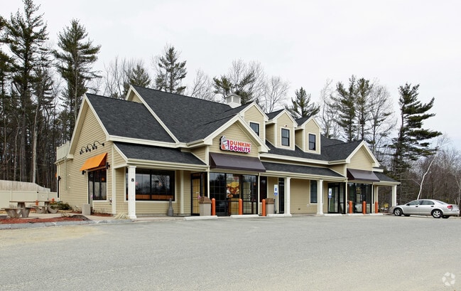
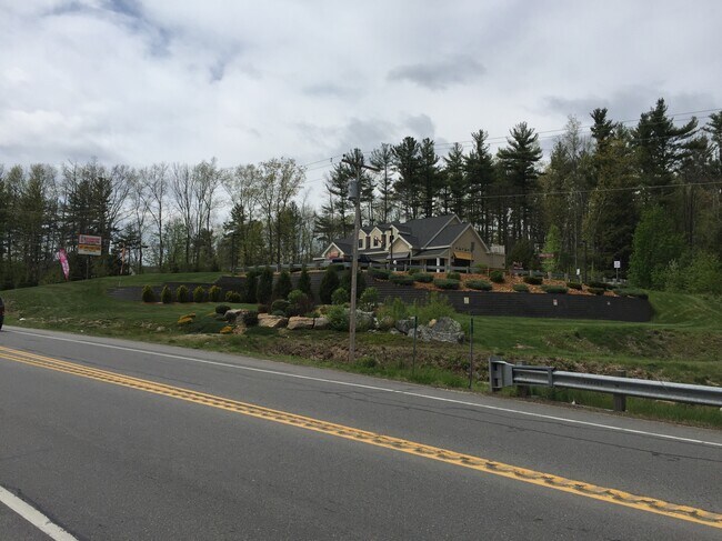
Property Record
8 Route 111, Atkinson, NH 03811

Property Detail
8 Route 111
ATKI-000021-000004-000002
ROCKINGHAM
Commercialbuilding
New Hampshire
C-I C
2
B and X Area of moderate flood hazard, usually the area between the limits of the 100-year and 500-year floods.
2.47 AC
2025
Rockingham
2025
Boston
103100
Boston-Cambridge-Newton, MA-NH
5,282 SF
NEARBY LISTINGS FOR SALE OR LEASE
DEMOGRAPHICS near 8 Route 111
1 mile
3 mile
5 mile
2025 Total Population
1,278
18,248
48,058
2030 Population
1,288
18,440
48,414
Pop Growth 2025-2030
+ 0.78%
+ 1.05%
+ 0.74%
Average Age
49
45
44
2025 Total Households
527
7,008
18,133
HH Growth 2025-2030
+ 0.76%
+ 0.94%
+ 0.59%
Median Household Inc
$135,937
$118,283
$125,689
Avg Household Size
2.40
2.60
2.60
2025 Avg HH Vehicles
2.00
2.00
2.00
Median Home Value
$570,084
$561,924
$549,197
Median Year Built
1983
1981
1982
Nearby Places
Map Layers
Map Styles
 Street
 Aerial
Layers
 Traffic
 Biking
Places
Listings with unknown addresses are not visible on the map
- Restaurants
- Banks
- Shops
- Fitness
- Groceries
PUBLIC TRANSPORTATION
COMMUTER RAIL
Haverhill (Haverhill Line - Massachusetts Bay Transportation Authority Commuter Rail (Purple Line))
Drive
Walk
Distance
Haverhill (Haverhill Line - Massachusetts Bay Transportation Authority Commuter Rail (Purple Line))
18 min
9.4 mi
Bradford (Haverhill Line - Massachusetts Bay Transportation Authority Commuter Rail (Purple Line))
Drive
Walk
Distance
Bradford (Haverhill Line - Massachusetts Bay Transportation Authority Commuter Rail (Purple Line))
19 min
9.9 mi
AIRPORT
Manchester Boston Regional
Drive
Walk
Distance
Manchester Boston Regional
37 min
22.0 mi
Portsmouth International at Pease
Drive
Walk
Distance
Portsmouth International at Pease
53 min
36.7 mi
Freight Ports
Port of Boston
Drive
Walk
Distance
Port of Boston
59 min
41.9 mi
SALE & LEASE HISTORY
LISTING DATE
SALE/LEASE

Nov 07, 2017
For Lease
Feb 05, 2021
For Lease
Nearby Properties
Address
Land Use
TOTAL SIZE
Lot Size
Zoning
Address
Land Use
TOTAL SIZE
Lot Size
Zoning
82,926 SF
40.38 AC
A-RES
Address
Land Use
TOTAL SIZE
Lot Size
Zoning
55,819 SF
382.76 AC
RR2SCR
Address
Land Use
TOTAL SIZE
Lot Size
Zoning
89,227 SF
89.88 AC
A-RES
Address
Land Use
TOTAL SIZE
Lot Size
Zoning
67,705 SF
10.93 AC
TC- TO
Address
Land Use
TOTAL SIZE
Lot Size
Zoning
12,187 SF
18.51 AC
A-RES
Address
Land Use
TOTAL SIZE
Lot Size
Zoning
145 AC
IND1
Address
Land Use
TOTAL SIZE
Lot Size
Zoning
58,661 SF
9.53 AC
A-RES
Address
Land Use
TOTAL SIZE
Lot Size
Zoning
863 SF
14.79 AC
B-RES
Address
Land Use
TOTAL SIZE
Lot Size
Zoning
1,358 SF
74.43 AC
D-MHPM
Address
Land Use
TOTAL SIZE
Lot Size
Zoning
115,964 SF
8.17 AC
C2 C
Address
Land Use
TOTAL SIZE
Lot Size
Zoning
231.50 AC
B-RES
Address
Land Use
TOTAL SIZE
Lot Size
Zoning
18,019 SF
10 AC
C2 C
Address
Land Use
TOTAL SIZE
Lot Size
Zoning
33,757 SF
6.43 AC
C2 C
Address
Land Use
TOTAL SIZE
Lot Size
Zoning
4,932 SF
15.62 AC
A-RES
Address
Land Use
TOTAL SIZE
Lot Size
Zoning
480 SF
A-RES
Address
Land Use
TOTAL SIZE
Lot Size
Zoning
16,368 SF
7.67 AC
C1 C
Address
Land Use
TOTAL SIZE
Lot Size
Zoning
71,420 SF
18.50 AC
C2 C
Address
Land Use
TOTAL SIZE
Lot Size
Zoning
4,003 SF
7.97 AC
A-RES
Address
Land Use
TOTAL SIZE
Lot Size
Zoning
30.36 AC
GC
Address
Land Use
TOTAL SIZE
Lot Size
Zoning
32,533 SF
9.46 AC
C2 C
Address
Land Use
TOTAL SIZE
Lot Size
Zoning
23,160 SF
2.82 AC
GC
Address
Land Use
TOTAL SIZE
Lot Size
Zoning
10,559 SF
1.52 AC
C1 C
Address
Land Use
TOTAL SIZE
Lot Size
Zoning
12,796 SF
7.09 AC
A-RES
Address
Land Use
TOTAL SIZE
Lot Size
Zoning
3,843 SF
9.37 AC
TC- TO
Address
Land Use
TOTAL SIZE
Lot Size
Zoning
35,870 SF
4.32 AC
LCSD
Address
Land Use
TOTAL SIZE
Lot Size
Zoning
7,463 SF
3.05 AC
A-RES
Address
Land Use
TOTAL SIZE
Lot Size
Zoning
842 SF
13.30 AC
B-RES
Address
Land Use
TOTAL SIZE
Lot Size
Zoning
2,906 SF
20.74 AC
RR2SCR
Address
Land Use
TOTAL SIZE
Lot Size
Zoning
57,938 SF
23.60 AC
RUR
Address
Land Use
TOTAL SIZE
Lot Size
Zoning
320 SF
13.40 AC
RUR
The World's #1 Commercial Real Estate Marketplace
Connect with us
© 2026 CoStar Group
The information above has been obtained from sources believed reliable. While we do not doubt its accuracy we have not verified it and make no guarantee, warranty or representation about it. It is your responsibility to independently confirm its accuracy and completeness. Any projections, opinions, assumptions, or estimates used are for example only and do not represent the current or future performance of the property. The value of this transaction to you depends on tax and other factors which should be evaluated by your tax, financial, and legal advisors. You and your advisors should conduct a careful, independent investigation of the property to determine to your satisfaction the suitability of the property for your needs.