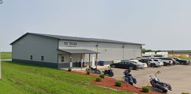
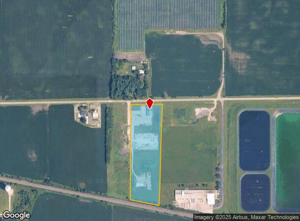
Property Record
8 S Hartness Pl, Cortland, IL 60112
NEARBY LISTINGS FOR SALE OR LEASE
Property Detail
8 S Hartness Pl
09-28-100-025
PT E 1/2 NW 1/4 - SEC 28 T40N R5E
Commercialnec
DeKalb
X
Illinois
17037C0275E
9.87 AC
2023
Central Kane / DuPage
2024
Chicago
001600
Chicago-Naperville-Elgin, IL-IN-WI
7,200 SF
DEMOGRAPHICS near 8 S Hartness Pl
1 Mile
3 Mile
5 Mile
2024 Total Population
2,275
5,444
41,371
2029 Population
2,356
5,531
40,993
Pop Growth 2024-2029
+ 3.56%
+ 1.60%
(0.91%)
Average Age
36
37
39
2024 Total Households
771
2,001
16,713
HH Growth 2024-2029
+ 3.37%
+ 1.30%
(1.12%)
Median Household Inc
$79,041
$78,281
$67,587
Avg Household Size
2.80
2.70
2.40
2024 Avg HH Vehicles
2.00
2.00
2.00
Median Home Value
$175,692
$169,693
$179,007
Median Year Built
2001
1996
1973
Nearby Places
Map Layers
Map Styles
 Street
 Aerial
- Restaurants
- Banks
- Shops
- Fitness
- Groceries
PUBLIC TRANSPORTATION
AIRPORT
Chicago/Rockford International
DRIVE
WALK
Distance
Chicago/Rockford International
62 min
44.6 mi
Freight Ports
Port Milwaukee
DRIVE
WALK
Distance
Port Milwaukee
144 min
102.3 mi
Nearby Properties
Address
Land Use
TOTAL SIZE
Lot Size
Zoning
Address
Land Use
TOTAL SIZE
Lot Size
Zoning
23.25 AC
Address
Land Use
TOTAL SIZE
Lot Size
Zoning
202,500 SF
15.65 AC
Address
Land Use
TOTAL SIZE
Lot Size
Zoning
240 SF
7.46 AC
Address
Land Use
TOTAL SIZE
Lot Size
Zoning
31.11 AC
A1
Address
Land Use
TOTAL SIZE
Lot Size
Zoning
16.23 AC
Address
Land Use
TOTAL SIZE
Lot Size
Zoning
92.65 AC
Address
Land Use
TOTAL SIZE
Lot Size
Zoning
Address
Land Use
TOTAL SIZE
Lot Size
Zoning
1.63 AC
Address
Land Use
TOTAL SIZE
Lot Size
Zoning
28,773 SF
20 AC
Address
Land Use
TOTAL SIZE
Lot Size
Zoning
2.17 AC
Address
Land Use
TOTAL SIZE
Lot Size
Zoning
4.65 AC
Address
Land Use
TOTAL SIZE
Lot Size
Zoning
2.27 AC
Address
Land Use
TOTAL SIZE
Lot Size
Zoning
5.99 AC
Address
Land Use
TOTAL SIZE
Lot Size
Zoning
1.98 AC
Address
Land Use
TOTAL SIZE
Lot Size
Zoning
2.89 AC
Address
Land Use
TOTAL SIZE
Lot Size
Zoning
1.51 AC
Address
Land Use
TOTAL SIZE
Lot Size
Zoning
40 AC
A1
Address
Land Use
TOTAL SIZE
Lot Size
Zoning
37.26 AC
A1
Address
Land Use
TOTAL SIZE
Lot Size
Zoning
115.60 AC
A1
Address
Land Use
TOTAL SIZE
Lot Size
Zoning
2.17 AC
Address
Land Use
TOTAL SIZE
Lot Size
Zoning
20,862 SF
5 AC
Address
Land Use
TOTAL SIZE
Lot Size
Zoning
3.32 AC
Address
Land Use
TOTAL SIZE
Lot Size
Zoning
4,450 SF
40 AC
A1
Address
Land Use
TOTAL SIZE
Lot Size
Zoning
16.21 AC
Address
Land Use
TOTAL SIZE
Lot Size
Zoning
2,459 SF
72.63 AC
A1
Address
Land Use
TOTAL SIZE
Lot Size
Zoning
17,011 SF
3 AC
Address
Land Use
TOTAL SIZE
Lot Size
Zoning
1.26 AC
Address
Land Use
TOTAL SIZE
Lot Size
Zoning
1.09 AC
Address
Land Use
TOTAL SIZE
Lot Size
Zoning
8,950 SF
1.15 AC
Address
Land Use
TOTAL SIZE
Lot Size
Zoning
The World's #1 Commercial Real Estate Marketplace
Connect with us
© 2026 CoStar Group
The information above has been obtained from sources believed reliable. While we do not doubt its accuracy we have not verified it and make no guarantee, warranty or representation about it. It is your responsibility to independently confirm its accuracy and completeness. Any projections, opinions, assumptions, or estimates used are for example only and do not represent the current or future performance of the property. The value of this transaction to you depends on tax and other factors which should be evaluated by your tax, financial, and legal advisors. You and your advisors should conduct a careful, independent investigation of the property to determine to your satisfaction the suitability of the property for your needs.