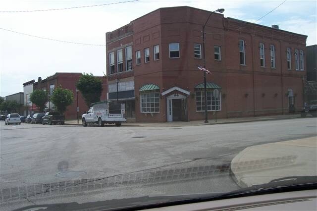
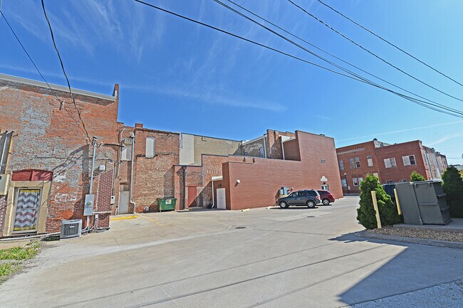
Property Record
8 S Main St, Canton, IL 61520

Property Detail
8 S Main St
Canton, IL
SECT/LOT: 47 JONES SECOND ADDITION N22 E 85
09-08-274-140-09
FULTON
Commercialnec
Illinois
B and X Area of moderate flood hazard, usually the area between the limits of the 100-year and 500-year floods.
47
2024
0.04 AC
2024
Illinois North Area
953400
Other Market Areas
1,809 SF
NEARBY LISTINGS FOR SALE OR LEASE
DEMOGRAPHICS near 8 S Main St
1 mile
3 mile
5 mile
2025 Total Population
8,842
13,508
15,221
2030 Population
8,706
13,194
14,818
Pop Growth 2025-2030
(1.54%)
(2.32%)
(2.65%)
Average Age
42
43
43
2025 Total Households
3,450
5,250
5,991
HH Growth 2025-2030
(1.80%)
(2.76%)
(3.05%)
Median Household Inc
$49,258
$54,564
$56,316
Avg Household Size
2.20
2.20
2.20
2025 Avg HH Vehicles
2.00
2.00
2.00
Median Home Value
$85,578
$109,922
$113,039
Median Year Built
1950
1957
1958
Nearby Places
Map Layers
Map Styles
 Street
 Aerial
Layers
 Traffic
 Biking
Places
Listings with unknown addresses are not visible on the map
- Restaurants
- Banks
- Shops
- Fitness
- Groceries
PUBLIC TRANSPORTATION
AIRPORT
General Downing - Peoria International
Drive
Walk
Distance
General Downing - Peoria International
45 min
31.1 mi
Freight Ports
Port Milwaukee
Drive
Walk
Distance
Port Milwaukee
309 min
258.3 mi
SALE & LEASE HISTORY
LISTING DATE
SALE/LEASE

Sep 25, 2016
For Lease
Feb 16, 2023
For Lease
Nearby Properties
Address
Land Use
TOTAL SIZE
Lot Size
Zoning
Address
Land Use
TOTAL SIZE
Lot Size
Zoning
Address
Land Use
TOTAL SIZE
Lot Size
Zoning
28,500 SF
1.74 AC
Address
Land Use
TOTAL SIZE
Lot Size
Zoning
Address
Land Use
TOTAL SIZE
Lot Size
Zoning
44,100 SF
5.97 AC
Address
Land Use
TOTAL SIZE
Lot Size
Zoning
Address
Land Use
TOTAL SIZE
Lot Size
Zoning
1.44 AC
Address
Land Use
TOTAL SIZE
Lot Size
Zoning
3.58 AC
Address
Land Use
TOTAL SIZE
Lot Size
Zoning
9,576 SF
2.33 AC
Address
Land Use
TOTAL SIZE
Lot Size
Zoning
75,353 SF
11.27 AC
Address
Land Use
TOTAL SIZE
Lot Size
Zoning
85,300 SF
6.26 AC
Address
Land Use
TOTAL SIZE
Lot Size
Zoning
1,200 SF
75.42 AC
Address
Land Use
TOTAL SIZE
Lot Size
Zoning
44,838 SF
4.87 AC
Address
Land Use
TOTAL SIZE
Lot Size
Zoning
4.83 AC
Address
Land Use
TOTAL SIZE
Lot Size
Zoning
10.04 AC
Address
Land Use
TOTAL SIZE
Lot Size
Zoning
2.16 AC
Address
Land Use
TOTAL SIZE
Lot Size
Zoning
14,756 SF
1.12 AC
Address
Land Use
TOTAL SIZE
Lot Size
Zoning
1.31 AC
Address
Land Use
TOTAL SIZE
Lot Size
Zoning
23,680 SF
0.09 AC
Address
Land Use
TOTAL SIZE
Lot Size
Zoning
0.96 AC
Address
Land Use
TOTAL SIZE
Lot Size
Zoning
Address
Land Use
TOTAL SIZE
Lot Size
Zoning
Address
Land Use
TOTAL SIZE
Lot Size
Zoning
Address
Land Use
TOTAL SIZE
Lot Size
Zoning
4.77 AC
Address
Land Use
TOTAL SIZE
Lot Size
Zoning
15,966 SF
1.34 AC
Address
Land Use
TOTAL SIZE
Lot Size
Zoning
5,840 SF
4.62 AC
Address
Land Use
TOTAL SIZE
Lot Size
Zoning
4,314 SF
1.03 AC
Address
Land Use
TOTAL SIZE
Lot Size
Zoning
0.69 AC
Address
Land Use
TOTAL SIZE
Lot Size
Zoning
Address
Land Use
TOTAL SIZE
Lot Size
Zoning
6,914 SF
0.78 AC
Address
Land Use
TOTAL SIZE
Lot Size
Zoning
7,000 SF
2.01 AC
The World's #1 Commercial Real Estate Marketplace
Connect with us
© 2026 CoStar Group
The information above has been obtained from sources believed reliable. While we do not doubt its accuracy we have not verified it and make no guarantee, warranty or representation about it. It is your responsibility to independently confirm its accuracy and completeness. Any projections, opinions, assumptions, or estimates used are for example only and do not represent the current or future performance of the property. The value of this transaction to you depends on tax and other factors which should be evaluated by your tax, financial, and legal advisors. You and your advisors should conduct a careful, independent investigation of the property to determine to your satisfaction the suitability of the property for your needs.