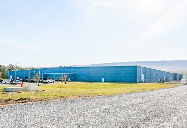
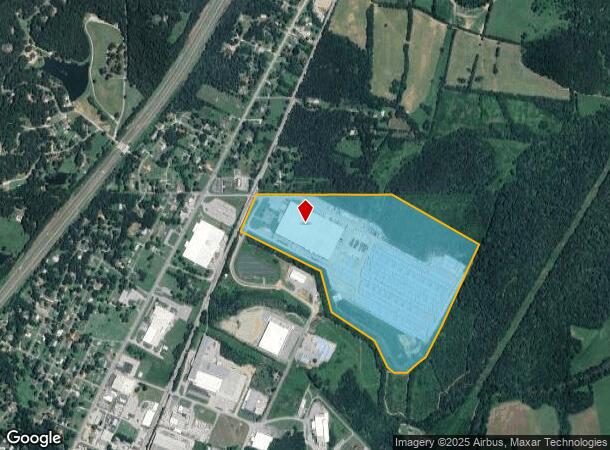
Property Record
8 Vanguard Dr, Trenton, GA 30752
NEARBY LISTINGS FOR SALE OR LEASE
-
-
View all Trenton listings for sale on LoopNet.com
Property Detail
8 Vanguard Dr
033-00-001-03
Ind-Trenton Ind Park
Governmentalpublicusegeneral
PTLLS 255 & 256 10/4 VANGUARD
X
Dade
47065C0430G
Georgia
0
98.19 AC
2025
Dade County
040103
Chattanooga
347,975 SF
Chattanooga, TN-GA
DEMOGRAPHICS near 8 Vanguard Dr
1 Mile
3 Mile
5 Mile
2024 Total Population
564
4,995
9,248
2029 Population
563
4,957
9,217
Pop Growth 2024-2029
(0.18%)
(0.76%)
(0.34%)
Average Age
41
40
41
2024 Total Households
226
2,064
3,775
HH Growth 2024-2029
(0.44%)
(0.97%)
(0.53%)
Median Household Inc
$33,333
$42,704
$44,958
Avg Household Size
2.40
2.40
2.40
2024 Avg HH Vehicles
2.00
2.00
2.00
Median Home Value
$131,159
$130,163
$148,583
Median Year Built
1983
1986
1985
Nearby Places
Map Layers
Map Styles
 Street
 Aerial
- Restaurants
- Banks
- Shops
- Fitness
- Groceries
PUBLIC TRANSPORTATION
AIRPORT
Lovell Field
DRIVE
WALK
Distance
Lovell Field
42 min
29.6 mi
Freight Ports
Georgia Ports - Savannah
DRIVE
WALK
Distance
Georgia Ports - Savannah
432 min
384.8 mi
Nearby Properties
Address
Land Use
TOTAL SIZE
Lot Size
Zoning
Address
Land Use
TOTAL SIZE
Lot Size
Zoning
92,474 SF
12.30 AC
Address
Land Use
TOTAL SIZE
Lot Size
Zoning
6,290 SF
19.50 AC
R-1
Address
Land Use
TOTAL SIZE
Lot Size
Zoning
15,220 SF
25.05 AC
R-1
Address
Land Use
TOTAL SIZE
Lot Size
Zoning
44,730 SF
29.24 AC
B-R
Address
Land Use
TOTAL SIZE
Lot Size
Zoning
61,468 SF
3.70 AC
M-1
Address
Land Use
TOTAL SIZE
Lot Size
Zoning
31,181 SF
1.93 AC
B-1
Address
Land Use
TOTAL SIZE
Lot Size
Zoning
41,460 SF
8.90 AC
B-3
Address
Land Use
TOTAL SIZE
Lot Size
Zoning
38,400 SF
18.60 AC
M-1
Address
Land Use
TOTAL SIZE
Lot Size
Zoning
115,683 SF
2.78 AC
M-1
Address
Land Use
TOTAL SIZE
Lot Size
Zoning
28,896 SF
0.96 AC
B-R
Address
Land Use
TOTAL SIZE
Lot Size
Zoning
56,864 SF
5.97 AC
B-R
Address
Land Use
TOTAL SIZE
Lot Size
Zoning
30,750 SF
1.25 AC
B-1
Address
Land Use
TOTAL SIZE
Lot Size
Zoning
83,770 SF
14.48 AC
M-1
Address
Land Use
TOTAL SIZE
Lot Size
Zoning
32,873 SF
5.96 AC
M-1
Address
Land Use
TOTAL SIZE
Lot Size
Zoning
58,310 SF
8.13 AC
M-1
Address
Land Use
TOTAL SIZE
Lot Size
Zoning
187,648 SF
13.50 AC
M-1
Address
Land Use
TOTAL SIZE
Lot Size
Zoning
17,952 SF
9.50 AC
B-R
Address
Land Use
TOTAL SIZE
Lot Size
Zoning
21,810 SF
10.63 AC
R-1
Address
Land Use
TOTAL SIZE
Lot Size
Zoning
25,966 SF
1.50 AC
B-1
Address
Land Use
TOTAL SIZE
Lot Size
Zoning
18,750 SF
3.61 AC
B-3
Address
Land Use
TOTAL SIZE
Lot Size
Zoning
58,649 SF
3.22 AC
B-R
Address
Land Use
TOTAL SIZE
Lot Size
Zoning
13,100 SF
5.09 AC
Address
Land Use
TOTAL SIZE
Lot Size
Zoning
13,007 SF
2 AC
B-R
Address
Land Use
TOTAL SIZE
Lot Size
Zoning
28,892 SF
4.72 AC
B-R
Address
Land Use
TOTAL SIZE
Lot Size
Zoning
36,360 SF
Address
Land Use
TOTAL SIZE
Lot Size
Zoning
6,153 SF
2 AC
Address
Land Use
TOTAL SIZE
Lot Size
Zoning
30,000 SF
9.20 AC
M-1
Address
Land Use
TOTAL SIZE
Lot Size
Zoning
14,320 SF
1.56 AC
B-3
Address
Land Use
TOTAL SIZE
Lot Size
Zoning
5,974 SF
2.01 AC
B-R
The World's #1 Commercial Real Estate Marketplace
Connect with us
© 2026 CoStar Group
The information above has been obtained from sources believed reliable. While we do not doubt its accuracy we have not verified it and make no guarantee, warranty or representation about it. It is your responsibility to independently confirm its accuracy and completeness. Any projections, opinions, assumptions, or estimates used are for example only and do not represent the current or future performance of the property. The value of this transaction to you depends on tax and other factors which should be evaluated by your tax, financial, and legal advisors. You and your advisors should conduct a careful, independent investigation of the property to determine to your satisfaction the suitability of the property for your needs.