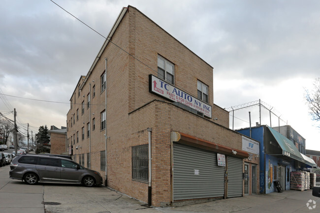
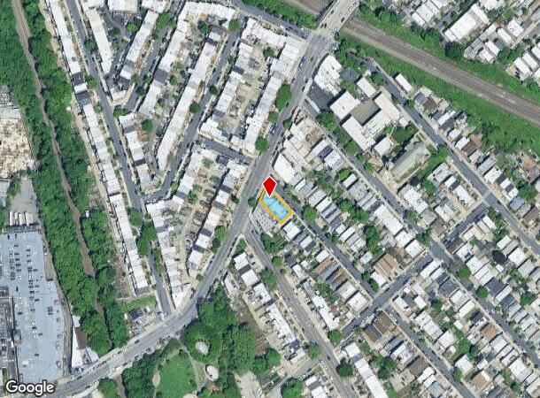
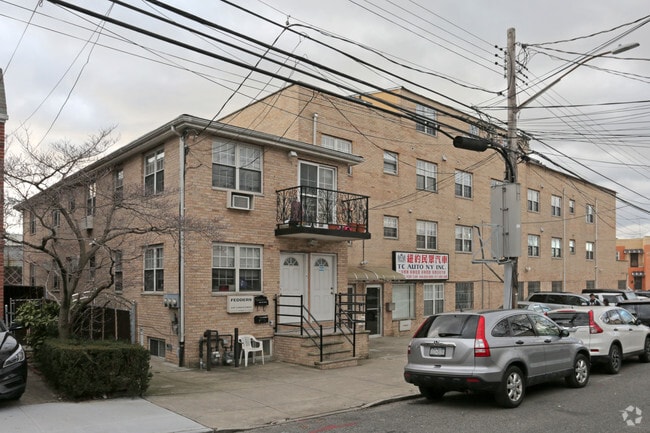
Property Record
8008 Grand Ave, Elmhurst, NY 11373

Current Lease Availabilities
NEARBY LISTINGS FOR SALE OR LEASE
Property Detail
8008 Grand Ave
02904-0003
Map Property J Bernheimer
Apartment
Queens
X
New York
3604970207F
3
2024
0.13 AC
2025
Central Queens
049900
Long Island (New York)
9,045 SF
New York-Jersey City-White Plains, NY-NJ
DEMOGRAPHICS near 8008 Grand Ave
1 Mile
3 Mile
5 Mile
2024 Total Population
124,039
858,783
2,544,711
2029 Population
115,042
803,103
2,381,163
Pop Growth 2024-2029
(7.25%)
(6.48%)
(6.43%)
Average Age
42
40
40
2024 Total Households
40,878
309,858
978,316
HH Growth 2024-2029
(7.70%)
(6.58%)
(6.63%)
Median Household Inc
$66,084
$72,629
$74,504
Avg Household Size
2.90
2.70
2.50
2024 Avg HH Vehicles
1.00
1.00
1.00
Median Home Value
$738,928
$678,726
$751,084
Median Year Built
1955
1950
1953
Nearby Places
Map Layers
Map Styles
 Street
 Aerial
- Restaurants
- Banks
- Shops
- Fitness
- Groceries
PUBLIC TRANSPORTATION
TRANSIT/SUBWAY
Grand Avenue-Newtown (E - New York MTA Subway (The Subway), M - New York MTA Subway (The Subway), R - New York MTA Subway (The Subway))
DRIVE
WALK
Distance
Grand Avenue-Newtown (E - New York MTA Subway (The Subway), M - New York MTA Subway (The Subway), R - New York MTA Subway (The Subway))
1 min
10 min
0.5 mi
Elmhurst Avenue (E - New York MTA Subway (The Subway), M - New York MTA Subway (The Subway), R - New York MTA Subway (The Subway))
DRIVE
WALK
Distance
Elmhurst Avenue (E - New York MTA Subway (The Subway), M - New York MTA Subway (The Subway), R - New York MTA Subway (The Subway))
3 min
17 min
0.9 mi
Woodhaven Boulevard (E,G,R Line) (E - New York MTA Subway (The Subway), M - New York MTA Subway (The Subway), R - New York MTA Subway (The Subway))
DRIVE
WALK
Distance
Woodhaven Boulevard (E,G,R Line) (E - New York MTA Subway (The Subway), M - New York MTA Subway (The Subway), R - New York MTA Subway (The Subway))
4 min
18 min
0.9 mi
COMMUTER RAIL
Woodside Station (Babylon Branch - Long Island Rail Road, Far Rockaway Branch - Long Island Rail Road, Hempstead Branch - Long Island Rail Road, Long Beach Branch - Long Island Rail Road, Montauk Branch - Long Island Rail Road, Port Jefferson Branch - Long Island Rail Road, Port Washington Branch - Long Island Rail Road, Ronkonkoma Branch - Long Island Rail Road)
DRIVE
WALK
Distance
Woodside Station (Babylon Branch - Long Island Rail Road, Far Rockaway Branch - Long Island Rail Road, Hempstead Branch - Long Island Rail Road, Long Beach Branch - Long Island Rail Road, Montauk Branch - Long Island Rail Road, Port Jefferson Branch - Long Island Rail Road, Port Washington Branch - Long Island Rail Road, Ronkonkoma Branch - Long Island Rail Road)
6 min
2.0 mi
Forest Hills Station (Babylon Branch - Long Island Rail Road, Hempstead Branch - Long Island Rail Road, Long Beach Branch - Long Island Rail Road, Port Jefferson Branch - Long Island Rail Road)
DRIVE
WALK
Distance
Forest Hills Station (Babylon Branch - Long Island Rail Road, Hempstead Branch - Long Island Rail Road, Long Beach Branch - Long Island Rail Road, Port Jefferson Branch - Long Island Rail Road)
8 min
2.7 mi
AIRPORT
LaGuardia
DRIVE
WALK
Distance
LaGuardia
11 min
3.8 mi
John F Kennedy International
DRIVE
WALK
Distance
John F Kennedy International
17 min
11.1 mi
Newark Liberty International
DRIVE
WALK
Distance
Newark Liberty International
32 min
20.4 mi
Freight Ports
NY - Red Hook Container Terminal
DRIVE
WALK
Distance
NY - Red Hook Container Terminal
18 min
9.2 mi
Nearby Properties
Address
Land Use
TOTAL SIZE
Lot Size
Zoning
Address
Land Use
TOTAL SIZE
Lot Size
Zoning
1,258,350 SF
410.24 AC
PARK
Address
Land Use
TOTAL SIZE
Lot Size
Zoning
1,502,532 SF
6.35 AC
R7B
Address
Land Use
TOTAL SIZE
Lot Size
Zoning
772,163 SF
5.24 AC
C4-5X
Address
Land Use
TOTAL SIZE
Lot Size
Zoning
54,170 SF
229.57 AC
PARK
Address
Land Use
TOTAL SIZE
Lot Size
Zoning
1,292,074 SF
C4-2F
Address
Land Use
TOTAL SIZE
Lot Size
Zoning
234,891 SF
3.17 AC
C4-5X
Address
Land Use
TOTAL SIZE
Lot Size
Zoning
882,579 SF
0.51 AC
M16R10
Address
Land Use
TOTAL SIZE
Lot Size
Zoning
1,516,458 SF
5.97 AC
R7-1
Address
Land Use
TOTAL SIZE
Lot Size
Zoning
15,000 SF
255.27 AC
PARK
Address
Land Use
TOTAL SIZE
Lot Size
Zoning
863,800 SF
2.71 AC
M1-4
Address
Land Use
TOTAL SIZE
Lot Size
Zoning
126.85 AC
PARK
Address
Land Use
TOTAL SIZE
Lot Size
Zoning
1,119,826 SF
2.76 AC
M1-4
Address
Land Use
TOTAL SIZE
Lot Size
Zoning
1,000 SF
210.07 AC
R3-2
Address
Land Use
TOTAL SIZE
Lot Size
Zoning
1,572,198 SF
22.06 AC
M1-2
Address
Land Use
TOTAL SIZE
Lot Size
Zoning
512,815 SF
0.63 AC
M16R10
Address
Land Use
TOTAL SIZE
Lot Size
Zoning
344,116 SF
0.92 AC
R7-1
Address
Land Use
TOTAL SIZE
Lot Size
Zoning
826,915 SF
8.83 AC
M3-1
Address
Land Use
TOTAL SIZE
Lot Size
Zoning
2,193 SF
94.72 AC
PARK
Address
Land Use
TOTAL SIZE
Lot Size
Zoning
360,000 SF
5.88 AC
C4-2
Address
Land Use
TOTAL SIZE
Lot Size
Zoning
307,038 SF
7.84 AC
M1-1
Address
Land Use
TOTAL SIZE
Lot Size
Zoning
458,778 SF
2.09 AC
R6
Address
Land Use
TOTAL SIZE
Lot Size
Zoning
490,600 SF
12.01 AC
M1-1
Address
Land Use
TOTAL SIZE
Lot Size
Zoning
480,000 SF
16.98 AC
M1-1
Address
Land Use
TOTAL SIZE
Lot Size
Zoning
248,200 SF
1.25 AC
R6
Address
Land Use
TOTAL SIZE
Lot Size
Zoning
550,909 SF
2.76 AC
M1-4
Address
Land Use
TOTAL SIZE
Lot Size
Zoning
88,700 SF
4.59 AC
M3-1
Address
Land Use
TOTAL SIZE
Lot Size
Zoning
595,000 SF
2.76 AC
M1-4
Address
Land Use
TOTAL SIZE
Lot Size
Zoning
266,195 SF
4.59 AC
C4-2
Address
Land Use
TOTAL SIZE
Lot Size
Zoning
272,081 SF
4.59 AC
C4-2
Address
Land Use
TOTAL SIZE
Lot Size
Zoning
240,000 SF
2.09 AC
R6
The World's #1 Commercial Real Estate Marketplace
Connect with us
© 2026 CoStar Group
The information above has been obtained from sources believed reliable. While we do not doubt its accuracy we have not verified it and make no guarantee, warranty or representation about it. It is your responsibility to independently confirm its accuracy and completeness. Any projections, opinions, assumptions, or estimates used are for example only and do not represent the current or future performance of the property. The value of this transaction to you depends on tax and other factors which should be evaluated by your tax, financial, and legal advisors. You and your advisors should conduct a careful, independent investigation of the property to determine to your satisfaction the suitability of the property for your needs.