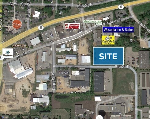
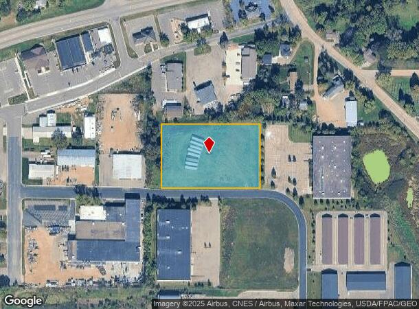
Property Record
80 E 8Th St, Waconia, MN 55387
NEARBY LISTINGS FOR SALE OR LEASE
Property Detail
80 E 8Th St
Minneapolis-St. Paul-Bloomington, MN-WI
Pine Business Park
75.3700040
Carver
Commercialnec
Minnesota
X
1
27019C0183D
2.37 AC
2025
Carver County Outlying
2025
Minneapolis/St Paul
090302
DEMOGRAPHICS near 80 E 8Th St
1 Mile
3 Mile
5 Mile
2024 Total Population
7,825
15,271
23,168
2029 Population
8,473
16,533
24,701
Pop Growth 2024-2029
+ 8.28%
+ 8.26%
+ 6.62%
Average Age
40
39
39
2024 Total Households
2,925
5,478
8,064
HH Growth 2024-2029
+ 8.58%
+ 8.53%
+ 6.91%
Median Household Inc
$83,109
$95,149
$104,397
Avg Household Size
2.60
2.70
2.80
2024 Avg HH Vehicles
2.00
2.00
2.00
Median Home Value
$393,731
$394,046
$395,728
Median Year Built
1994
1999
1999
Nearby Places
Map Layers
Map Styles
 Street
 Aerial
- Restaurants
- Banks
- Shops
- Fitness
- Groceries
PUBLIC TRANSPORTATION
AIRPORT
Minneapolis-St Paul International/Wold-Chamberlain
DRIVE
WALK
Distance
Minneapolis-St Paul International/Wold-Chamberlain
45 min
31.6 mi
Freight Ports
Port Milwaukee
DRIVE
WALK
Distance
Port Milwaukee
413 min
368.8 mi
SALE & LEASE HISTORY
LISTING DATE
SALE/LEASE

Sep 24, 2016
For Sale
Jul 25, 2024
For Sale
Dec 08, 2022
For Sale
Nearby Properties
Address
Land Use
TOTAL SIZE
Lot Size
Zoning
Address
Land Use
TOTAL SIZE
Lot Size
Zoning
218,348 SF
12.89 AC
Address
Land Use
TOTAL SIZE
Lot Size
Zoning
50,530 SF
14.99 AC
Address
Land Use
TOTAL SIZE
Lot Size
Zoning
200,083 SF
58.28 AC
Address
Land Use
TOTAL SIZE
Lot Size
Zoning
10.72 AC
Address
Land Use
TOTAL SIZE
Lot Size
Zoning
23,645 SF
0.62 AC
Address
Land Use
TOTAL SIZE
Lot Size
Zoning
55,559 SF
55.16 AC
Address
Land Use
TOTAL SIZE
Lot Size
Zoning
16,876 SF
2.30 AC
Address
Land Use
TOTAL SIZE
Lot Size
Zoning
7.68 AC
Address
Land Use
TOTAL SIZE
Lot Size
Zoning
10.79 AC
Address
Land Use
TOTAL SIZE
Lot Size
Zoning
62,580 SF
10.19 AC
Address
Land Use
TOTAL SIZE
Lot Size
Zoning
3.13 AC
Address
Land Use
TOTAL SIZE
Lot Size
Zoning
6,392 SF
8.52 AC
Address
Land Use
TOTAL SIZE
Lot Size
Zoning
4.09 AC
Address
Land Use
TOTAL SIZE
Lot Size
Zoning
24,051 SF
4.17 AC
Address
Land Use
TOTAL SIZE
Lot Size
Zoning
132,018 SF
17.38 AC
Address
Land Use
TOTAL SIZE
Lot Size
Zoning
77,895 SF
11.45 AC
Address
Land Use
TOTAL SIZE
Lot Size
Zoning
41,970 SF
3.67 AC
Address
Land Use
TOTAL SIZE
Lot Size
Zoning
7,599 SF
0.78 AC
Address
Land Use
TOTAL SIZE
Lot Size
Zoning
16.62 AC
Address
Land Use
TOTAL SIZE
Lot Size
Zoning
2.68 AC
Address
Land Use
TOTAL SIZE
Lot Size
Zoning
9,450 SF
4.44 AC
Address
Land Use
TOTAL SIZE
Lot Size
Zoning
5.29 AC
Address
Land Use
TOTAL SIZE
Lot Size
Zoning
4.38 AC
Address
Land Use
TOTAL SIZE
Lot Size
Zoning
24,924 SF
3.03 AC
Address
Land Use
TOTAL SIZE
Lot Size
Zoning
73,840 SF
3.85 AC
Address
Land Use
TOTAL SIZE
Lot Size
Zoning
10,188 SF
4.48 AC
Address
Land Use
TOTAL SIZE
Lot Size
Zoning
20,336 SF
3.43 AC
Address
Land Use
TOTAL SIZE
Lot Size
Zoning
31.70 AC
Address
Land Use
TOTAL SIZE
Lot Size
Zoning
8,740 SF
0.76 AC
Address
Land Use
TOTAL SIZE
Lot Size
Zoning
15,700 SF
3.44 AC
The World's #1 Commercial Real Estate Marketplace
Connect with us
© 2026 CoStar Group
The information above has been obtained from sources believed reliable. While we do not doubt its accuracy we have not verified it and make no guarantee, warranty or representation about it. It is your responsibility to independently confirm its accuracy and completeness. Any projections, opinions, assumptions, or estimates used are for example only and do not represent the current or future performance of the property. The value of this transaction to you depends on tax and other factors which should be evaluated by your tax, financial, and legal advisors. You and your advisors should conduct a careful, independent investigation of the property to determine to your satisfaction the suitability of the property for your needs.