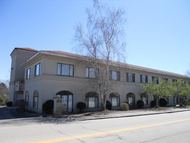
Property Record
80 Bridge St, Dedham, MA 02026

Property Detail
80 Bridge St
DEDH-000014-000000-000054
Norfolk
Apartment
Massachusetts
GB
54
AE The base floodplain where base flood elevations are provided. AE Zones are now used on new format FIRMs instead of A1-A30 Zones.
1.10 AC
2025
Route 1 South
2025
Boston
402101
Boston-Cambridge-Newton, MA-NH
43,476 SF
NEARBY LISTINGS FOR SALE OR LEASE
DEMOGRAPHICS near 80 Bridge St
1 mile
3 mile
5 mile
2025 Total Population
9,937
113,529
312,082
2030 Population
10,233
115,887
319,161
Pop Growth 2025-2030
+ 2.98%
+ 2.08%
+ 2.27%
Average Age
45
43
41
2025 Total Households
4,255
43,704
115,561
HH Growth 2025-2030
+ 3.22%
+ 2.15%
+ 2.36%
Median Household Inc
$119,201
$132,742
$133,040
Avg Household Size
2.30
2.50
2.50
2025 Avg HH Vehicles
2.00
2.00
2.00
Median Home Value
$680,408
$797,442
$858,427
Median Year Built
1956
1952
1952
Nearby Places
Map Layers
Map Styles
 Street
 Aerial
Transit
 Traffic
 Biking
Places
Listings with unknown addresses are not visible on the map
- Restaurants
- Banks
- Shops
- Fitness
- Groceries
PUBLIC TRANSPORTATION
COMMUTER RAIL
West Roxbury (Needham Line - Massachusetts Bay Transportation Authority Commuter Rail (Purple Line))
Drive
Walk
Distance
West Roxbury (Needham Line - Massachusetts Bay Transportation Authority Commuter Rail (Purple Line))
3 min
1.4 mi
Highland (Needham Line - Massachusetts Bay Transportation Authority Commuter Rail (Purple Line))
Drive
Walk
Distance
Highland (Needham Line - Massachusetts Bay Transportation Authority Commuter Rail (Purple Line))
4 min
1.7 mi
AIRPORT
General Edward Lawrence Logan International
Drive
Walk
Distance
General Edward Lawrence Logan International
26 min
13.9 mi
Freight Ports
Port of Boston
Drive
Walk
Distance
Port of Boston
24 min
12.3 mi
SALE & LEASE HISTORY
LISTING DATE
SALE/LEASE

Sep 25, 2016
For Lease
Nearby Properties
Address
Land Use
TOTAL SIZE
Lot Size
Zoning
Address
Land Use
TOTAL SIZE
Lot Size
Zoning
30,845 SF
50.36 AC
SR1
Address
Land Use
TOTAL SIZE
Lot Size
Zoning
317,049 SF
11.22 AC
M05
Address
Land Use
TOTAL SIZE
Lot Size
Zoning
45,000 SF
14.30 AC
E
Address
Land Use
TOTAL SIZE
Lot Size
Zoning
355,941 SF
4.60 AC
A
Address
Land Use
TOTAL SIZE
Lot Size
Zoning
413,827 SF
9.49 AC
RDO
Address
Land Use
TOTAL SIZE
Lot Size
Zoning
179.13 AC
E
Address
Land Use
TOTAL SIZE
Lot Size
Zoning
11.66 AC
LM
Address
Land Use
TOTAL SIZE
Lot Size
Zoning
151,232 SF
8.27 AC
PUB
Address
Land Use
TOTAL SIZE
Lot Size
Zoning
208,500 SF
13.98 AC
I
Address
Land Use
TOTAL SIZE
Lot Size
Zoning
59.94 AC
PUB
Address
Land Use
TOTAL SIZE
Lot Size
Zoning
34.93 AC
LM
Address
Land Use
TOTAL SIZE
Lot Size
Zoning
21,830 SF
158.48 AC
E
Address
Land Use
TOTAL SIZE
Lot Size
Zoning
3.18 AC
M05
Address
Land Use
TOTAL SIZE
Lot Size
Zoning
26,569 SF
45.93 AC
RC
Address
Land Use
TOTAL SIZE
Lot Size
Zoning
332,100 SF
4.63 AC
M05
Address
Land Use
TOTAL SIZE
Lot Size
Zoning
8.18 AC
B
Address
Land Use
TOTAL SIZE
Lot Size
Zoning
22.95 AC
E
Address
Land Use
TOTAL SIZE
Lot Size
Zoning
408,199 SF
23.35 AC
NEBC
Address
Land Use
TOTAL SIZE
Lot Size
Zoning
96,167 SF
8.04 AC
PUB
Address
Land Use
TOTAL SIZE
Lot Size
Zoning
4,216 SF
6.02 AC
SRA
Address
Land Use
TOTAL SIZE
Lot Size
Zoning
260,552 SF
12.80 AC
LMD
Address
Land Use
TOTAL SIZE
Lot Size
Zoning
211,500 SF
12.09 AC
I
Address
Land Use
TOTAL SIZE
Lot Size
Zoning
475,102 SF
36.81 AC
A
Address
Land Use
TOTAL SIZE
Lot Size
Zoning
45.72 AC
LM
Address
Land Use
TOTAL SIZE
Lot Size
Zoning
15 AC
Address
Land Use
TOTAL SIZE
Lot Size
Zoning
121,141 SF
19.58 AC
SR1
Address
Land Use
TOTAL SIZE
Lot Size
Zoning
7.45 AC
M05
Address
Land Use
TOTAL SIZE
Lot Size
Zoning
141,322 SF
36.84 AC
Address
Land Use
TOTAL SIZE
Lot Size
Zoning
99,104 SF
11.48 AC
S10
Address
Land Use
TOTAL SIZE
Lot Size
Zoning
156,310 SF
9.40 AC
E
The World's #1 Commercial Real Estate Marketplace
Connect with us
© 2026 CoStar Group
The information above has been obtained from sources believed reliable. While we do not doubt its accuracy we have not verified it and make no guarantee, warranty or representation about it. It is your responsibility to independently confirm its accuracy and completeness. Any projections, opinions, assumptions, or estimates used are for example only and do not represent the current or future performance of the property. The value of this transaction to you depends on tax and other factors which should be evaluated by your tax, financial, and legal advisors. You and your advisors should conduct a careful, independent investigation of the property to determine to your satisfaction the suitability of the property for your needs.