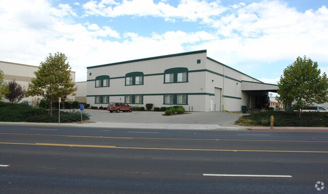
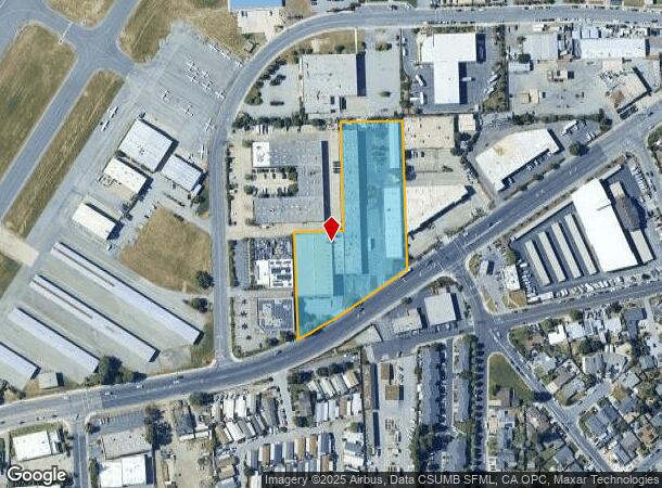
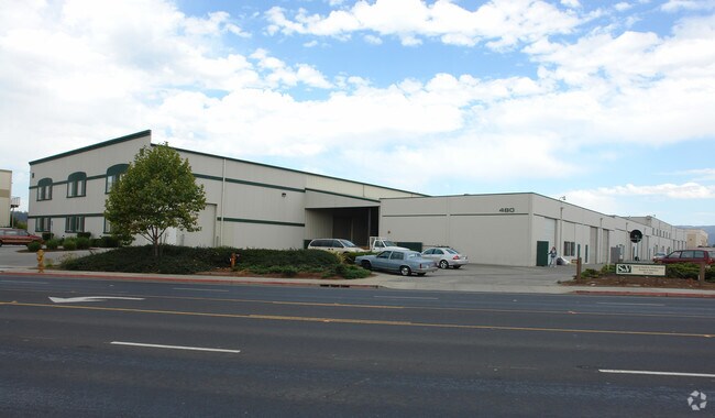
Property Record
480 Airport Blvd, Watsonville, CA 95076
NEARBY LISTINGS FOR SALE OR LEASE
Property Detail
480 Airport Blvd
015-131-33-000
Santa Cruz
Lightindustrial
California
X
2.88 AC
06087C0391E
Watsonville
2024
Santa Cruz/Watsonville
2025
Santa Cruz-Watsonville, CA
110700
DEMOGRAPHICS near 480 Airport Blvd
1 Mile
3 Mile
5 Mile
2024 Total Population
14,673
63,581
78,529
2029 Population
14,255
61,637
76,059
Pop Growth 2024-2029
(2.85%)
(3.06%)
(3.15%)
Average Age
36
36
37
2024 Total Households
3,877
16,996
22,002
HH Growth 2024-2029
(3.20%)
(3.42%)
(3.46%)
Median Household Inc
$71,206
$75,878
$81,980
Avg Household Size
3.60
3.50
3.40
2024 Avg HH Vehicles
2.00
2.00
2.00
Median Home Value
$604,303
$649,175
$725,773
Median Year Built
1974
1973
1974
Nearby Places
- Restaurants
- Banks
- Shops
- Fitness
- Groceries
PUBLIC TRANSPORTATION
AIRPORT
Monterey Regional
DRIVE
WALK
Distance
Monterey Regional
37 min
29.2 mi
Freight Ports
Port of Redwood City
DRIVE
WALK
Distance
Port of Redwood City
79 min
61.2 mi
Nearby Properties
Address
Land Use
TOTAL SIZE
Lot Size
Zoning
Address
Land Use
TOTAL SIZE
Lot Size
Zoning
3,767 SF
6.90 AC
RM-2-R
Address
Land Use
TOTAL SIZE
Lot Size
Zoning
163,824 SF
13.98 AC
Address
Land Use
TOTAL SIZE
Lot Size
Zoning
155,402 SF
11.53 AC
Address
Land Use
TOTAL SIZE
Lot Size
Zoning
193,645 SF
25.70 AC
Address
Land Use
TOTAL SIZE
Lot Size
Zoning
60,392 SF
4.07 AC
RM-4
Address
Land Use
TOTAL SIZE
Lot Size
Zoning
77,449 SF
14.38 AC
R-1-6
Address
Land Use
TOTAL SIZE
Lot Size
Zoning
64,650 SF
6.04 AC
Address
Land Use
TOTAL SIZE
Lot Size
Zoning
146,574 SF
9.97 AC
Address
Land Use
TOTAL SIZE
Lot Size
Zoning
Address
Land Use
TOTAL SIZE
Lot Size
Zoning
94,674 SF
3.38 AC
Address
Land Use
TOTAL SIZE
Lot Size
Zoning
2.34 AC
Address
Land Use
TOTAL SIZE
Lot Size
Zoning
5,963 SF
7.89 AC
Address
Land Use
TOTAL SIZE
Lot Size
Zoning
373,950 SF
16.47 AC
Address
Land Use
TOTAL SIZE
Lot Size
Zoning
8.45 AC
Address
Land Use
TOTAL SIZE
Lot Size
Zoning
8.64 AC
Address
Land Use
TOTAL SIZE
Lot Size
Zoning
7.94 AC
Address
Land Use
TOTAL SIZE
Lot Size
Zoning
59,897 SF
1.54 AC
Address
Land Use
TOTAL SIZE
Lot Size
Zoning
4.59 AC
CA
Address
Land Use
TOTAL SIZE
Lot Size
Zoning
41,700 SF
3 AC
PA
Address
Land Use
TOTAL SIZE
Lot Size
Zoning
58,495 SF
1.77 AC
Address
Land Use
TOTAL SIZE
Lot Size
Zoning
10.47 AC
CAW
Address
Land Use
TOTAL SIZE
Lot Size
Zoning
Address
Land Use
TOTAL SIZE
Lot Size
Zoning
40,585 SF
2.40 AC
R-1-6
Address
Land Use
TOTAL SIZE
Lot Size
Zoning
14.98 AC
PF
Address
Land Use
TOTAL SIZE
Lot Size
Zoning
53,672 SF
5.14 AC
Address
Land Use
TOTAL SIZE
Lot Size
Zoning
64,472 SF
3.27 AC
Address
Land Use
TOTAL SIZE
Lot Size
Zoning
7.02 AC
Address
Land Use
TOTAL SIZE
Lot Size
Zoning
65,782 SF
3.60 AC
Address
Land Use
TOTAL SIZE
Lot Size
Zoning
75,884 SF
2.03 AC
Address
Land Use
TOTAL SIZE
Lot Size
Zoning
2.56 AC
The World's #1 Commercial Real Estate Marketplace
Connect with us
© 2025 CoStar Group
The information above has been obtained from sources believed reliable. While we do not doubt its accuracy we have not verified it and make no guarantee, warranty or representation about it. It is your responsibility to independently confirm its accuracy and completeness. Any projections, opinions, assumptions, or estimates used are for example only and do not represent the current or future performance of the property. The value of this transaction to you depends on tax and other factors which should be evaluated by your tax, financial, and legal advisors. You and your advisors should conduct a careful, independent investigation of the property to determine to your satisfaction the suitability of the property for your needs.