Property Record
80 Alliance Dr, Whiteville, NC 28472


Save to a Folder
{{folder.Name}}
{{folder.ListingIds.length}} Properties
{{folder.ListingIds.length}} Property
Create a New Folder
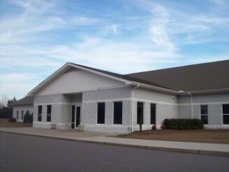
Property Detail
80 Alliance Dr
0061196
TRACT#2
Privateschool
Columbus
2025
North Carolina
2025
9.10 AC
930800
North Carolina Southeast Area
11,080 SF
Other Market Areas
NEARBY LISTINGS FOR SALE OR LEASE
-
-
View all Whiteville listings for sale on LoopNet.com
DEMOGRAPHICS near 80 Alliance Dr
1 mile
3 mile
5 mile
2025 Total Population
1,624
7,386
11,407
2030 Population
1,593
7,363
11,366
Pop Growth 2025-2030
(1.91%)
(0.31%)
(0.36%)
Average Age
44
43
43
2025 Total Households
676
3,157
4,731
HH Growth 2025-2030
(1.92%)
(0.22%)
(0.32%)
Median Household Inc
$67,343
$47,364
$48,982
Avg Household Size
2.30
2.20
2.20
2025 Avg HH Vehicles
2.00
2.00
2.00
Median Home Value
$183,185
$187,445
$172,813
Median Year Built
1971
1975
1977
Nearby Places
Map Layers
Map Styles
 Street
 Aerial
Layers
 Traffic
 Biking
Places
Listings with unknown addresses are not visible on the map
- Restaurants
- Banks
- Shops
- Fitness
- Groceries
Nearby Properties
Address
Land Use
TOTAL SIZE
Lot Size
Zoning
Address
Land Use
TOTAL SIZE
Lot Size
Zoning
40,780 SF
29.66 AC
Address
Land Use
TOTAL SIZE
Lot Size
Zoning
21,560 SF
1.38 AC
Address
Land Use
TOTAL SIZE
Lot Size
Zoning
64,022 SF
11.19 AC
Address
Land Use
TOTAL SIZE
Lot Size
Zoning
86,000 SF
3.01 AC
Address
Land Use
TOTAL SIZE
Lot Size
Zoning
18,148 SF
Address
Land Use
TOTAL SIZE
Lot Size
Zoning
42,984 SF
5.80 AC
Address
Land Use
TOTAL SIZE
Lot Size
Zoning
1,820 SF
2.02 AC
Address
Land Use
TOTAL SIZE
Lot Size
Zoning
34,206 SF
55.90 AC
Address
Land Use
TOTAL SIZE
Lot Size
Zoning
50,148 SF
5.83 AC
Address
Land Use
TOTAL SIZE
Lot Size
Zoning
12,766 SF
2.12 AC
Address
Land Use
TOTAL SIZE
Lot Size
Zoning
67,291 SF
6.95 AC
Address
Land Use
TOTAL SIZE
Lot Size
Zoning
127,142 SF
13.08 AC
Address
Land Use
TOTAL SIZE
Lot Size
Zoning
70,581 SF
7.43 AC
Address
Land Use
TOTAL SIZE
Lot Size
Zoning
1,263 SF
5.76 AC
Address
Land Use
TOTAL SIZE
Lot Size
Zoning
1,263 SF
5.53 AC
Address
Land Use
TOTAL SIZE
Lot Size
Zoning
64,598 SF
8.95 AC
Address
Land Use
TOTAL SIZE
Lot Size
Zoning
45,447 SF
3.95 AC
Address
Land Use
TOTAL SIZE
Lot Size
Zoning
19,820 SF
Address
Land Use
TOTAL SIZE
Lot Size
Zoning
30,464 SF
1.95 AC
Address
Land Use
TOTAL SIZE
Lot Size
Zoning
25,720 SF
2.75 AC
Address
Land Use
TOTAL SIZE
Lot Size
Zoning
63,305 SF
4.70 AC
Address
Land Use
TOTAL SIZE
Lot Size
Zoning
14,406 SF
1.70 AC
Address
Land Use
TOTAL SIZE
Lot Size
Zoning
33,386 SF
10.40 AC
Address
Land Use
TOTAL SIZE
Lot Size
Zoning
103,128 SF
2.71 AC
Address
Land Use
TOTAL SIZE
Lot Size
Zoning
3,840 SF
13.66 AC
Address
Land Use
TOTAL SIZE
Lot Size
Zoning
28,868 SF
2.91 AC
Address
Land Use
TOTAL SIZE
Lot Size
Zoning
22,320 SF
28.97 AC
Address
Land Use
TOTAL SIZE
Lot Size
Zoning
21,466 SF
10.48 AC
Address
Land Use
TOTAL SIZE
Lot Size
Zoning
3,600 SF
3.08 AC
Address
Land Use
TOTAL SIZE
Lot Size
Zoning
11,600 SF
1.38 AC
The World's #1 Commercial Real Estate Marketplace
Connect with us
© 2026 CoStar Group
The information above has been obtained from sources believed reliable. While we do not doubt its accuracy we have not verified it and make no guarantee, warranty or representation about it. It is your responsibility to independently confirm its accuracy and completeness. Any projections, opinions, assumptions, or estimates used are for example only and do not represent the current or future performance of the property. The value of this transaction to you depends on tax and other factors which should be evaluated by your tax, financial, and legal advisors. You and your advisors should conduct a careful, independent investigation of the property to determine to your satisfaction the suitability of the property for your needs.