Property Record
80 Averill Rd, Pomfret Center, CT 06259

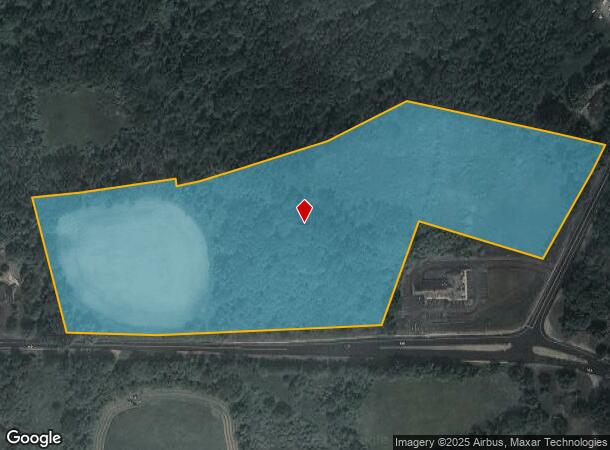
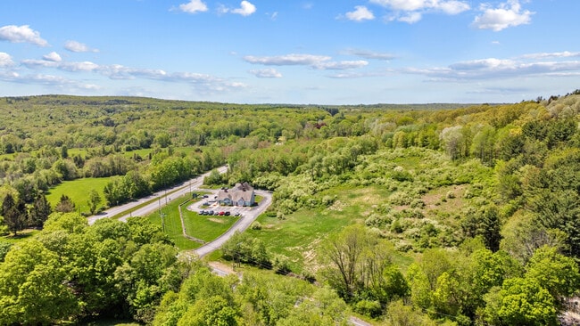
This Property Is For Sale
NEARBY LISTINGS FOR SALE OR LEASE
Property Detail
80 Averill Rd
POMF-000030-A000000-000003
Windham
Residentialacreage
Connecticut
X
3.00
09015C0227F
15.91 AC
2025
Windham County
2025
Hartford
902500
Willimantic, CT
1,431 SF
DEMOGRAPHICS near 80 Averill Rd
1 mile
3 mile
5 mile
2024 Total Population
374
2,913
14,051
2029 Population
367
2,867
13,931
Pop Growth 2024-2029
(1.87%)
(1.58%)
(0.85%)
Average Age
42
42
42
2024 Total Households
139
1,051
5,556
HH Growth 2024-2029
(1.44%)
(1.90%)
(0.86%)
Median Household Inc
$88,888
$87,826
$80,740
Avg Household Size
2.50
2.50
2.40
2024 Avg HH Vehicles
2.00
2.00
2.00
Median Home Value
$354,838
$352,156
$283,524
Median Year Built
1977
1978
1972
Nearby Places
Map Layers
Map Styles
 Street
 Aerial
Transit
 Traffic
 Biking
Places
Listings with unknown addresses are not visible on the map
- Restaurants
- Banks
- Shops
- Fitness
- Groceries
PUBLIC TRANSPORTATION
AIRPORT
Worcester Regional
Drive
Walk
Distance
Worcester Regional
52 min
35.1 mi
Rhode Island Tf Green International
Drive
Walk
Distance
Rhode Island Tf Green International
53 min
35.8 mi
Freight Ports
Port of Davisville, RI
Drive
Walk
Distance
Port of Davisville, RI
65 min
45.1 mi
Nearby Properties
Address
Land Use
TOTAL SIZE
Lot Size
Zoning
Address
Land Use
TOTAL SIZE
Lot Size
Zoning
7,883 SF
141.24 AC
PSR
Address
Land Use
TOTAL SIZE
Lot Size
Zoning
16,392 SF
101.85 AC
PSR
Address
Land Use
TOTAL SIZE
Lot Size
Zoning
65,888 SF
9.40 AC
RR
Address
Land Use
TOTAL SIZE
Lot Size
Zoning
25.60 AC
PSR
Address
Land Use
TOTAL SIZE
Lot Size
Zoning
45.60 AC
RR
Address
Land Use
TOTAL SIZE
Lot Size
Zoning
27.10 AC
BV/CB
Address
Land Use
TOTAL SIZE
Lot Size
Zoning
41,730 SF
21.30 AC
RR
Address
Land Use
TOTAL SIZE
Lot Size
Zoning
16.40 AC
PSR
Address
Land Use
TOTAL SIZE
Lot Size
Zoning
37,072 SF
3.79 AC
PSR
Address
Land Use
TOTAL SIZE
Lot Size
Zoning
18,073 SF
5.10 AC
PSR
Address
Land Use
TOTAL SIZE
Lot Size
Zoning
28,187 SF
9.95 AC
RR
Address
Land Use
TOTAL SIZE
Lot Size
Zoning
6.46 AC
PSR
Address
Land Use
TOTAL SIZE
Lot Size
Zoning
13,978 SF
11.01 AC
PSR
Address
Land Use
TOTAL SIZE
Lot Size
Zoning
Address
Land Use
TOTAL SIZE
Lot Size
Zoning
52.20 AC
RR
Address
Land Use
TOTAL SIZE
Lot Size
Zoning
62.50 AC
RR
Address
Land Use
TOTAL SIZE
Lot Size
Zoning
470.60 AC
RR
Address
Land Use
TOTAL SIZE
Lot Size
Zoning
473.10 AC
RR
Address
Land Use
TOTAL SIZE
Lot Size
Zoning
71.23 AC
RR
Address
Land Use
TOTAL SIZE
Lot Size
Zoning
29,124 SF
20.20 AC
CB
Address
Land Use
TOTAL SIZE
Lot Size
Zoning
Address
Land Use
TOTAL SIZE
Lot Size
Zoning
7,772 SF
41 AC
RR
Address
Land Use
TOTAL SIZE
Lot Size
Zoning
8.30 AC
PSR
Address
Land Use
TOTAL SIZE
Lot Size
Zoning
5,478 SF
1.50 AC
PSR
Address
Land Use
TOTAL SIZE
Lot Size
Zoning
28.20 AC
RR
Address
Land Use
TOTAL SIZE
Lot Size
Zoning
36.20 AC
RR
Address
Land Use
TOTAL SIZE
Lot Size
Zoning
6,200 SF
76 AC
PSR
Address
Land Use
TOTAL SIZE
Lot Size
Zoning
18.34 AC
PSR
Address
Land Use
TOTAL SIZE
Lot Size
Zoning
0.13 AC
RR
Address
Land Use
TOTAL SIZE
Lot Size
Zoning
1.40 AC
PSR
The World's #1 Commercial Real Estate Marketplace
Connect with us
© 2026 CoStar Group
The information above has been obtained from sources believed reliable. While we do not doubt its accuracy we have not verified it and make no guarantee, warranty or representation about it. It is your responsibility to independently confirm its accuracy and completeness. Any projections, opinions, assumptions, or estimates used are for example only and do not represent the current or future performance of the property. The value of this transaction to you depends on tax and other factors which should be evaluated by your tax, financial, and legal advisors. You and your advisors should conduct a careful, independent investigation of the property to determine to your satisfaction the suitability of the property for your needs.