Property Record
80 Carolina Point Pkwy, Greenville, SC 29607


NEARBY LISTINGS FOR SALE OR LEASE
Property Detail
80 Carolina Point Pkwy
Greenville-Anderson-Mauldin, SC
The Point
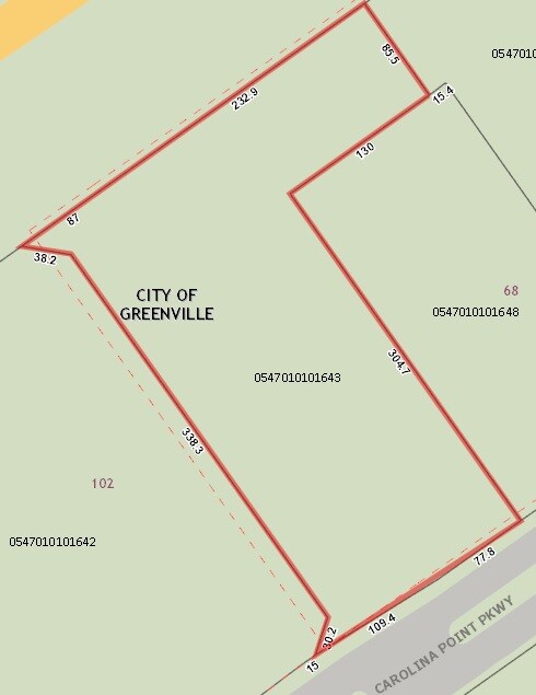
0547.01-01-016.43
130 121 PH2
Motel
Greenville
X
South Carolina
45045C0408E
016.43
2025
2.74 AC
2024
Woodruff/I-385 Corridor
002811
Greenville/Spartanburg
DEMOGRAPHICS near 80 Carolina Point Pkwy
1 Mile
3 Mile
5 Mile
2024 Total Population
4,121
54,842
163,363
2029 Population
4,596
60,932
179,967
Pop Growth 2024-2029
+ 11.53%
+ 11.10%
+ 10.16%
Average Age
38
40
40
2024 Total Households
1,883
24,826
69,218
HH Growth 2024-2029
+ 11.63%
+ 11.24%
+ 10.35%
Median Household Inc
$75,035
$78,508
$76,414
Avg Household Size
2.20
2.20
2.30
2024 Avg HH Vehicles
2.00
2.00
2.00
Median Home Value
$269,330
$288,960
$291,711
Median Year Built
2009
1995
1990
Nearby Places
Map Layers
Map Styles
 Street
 Aerial
- Restaurants
- Banks
- Shops
- Fitness
- Groceries
PUBLIC TRANSPORTATION
COMMUTER RAIL
Greenville Amtrak Station (Crescent - Amtrak)
DRIVE
WALK
Distance
Greenville Amtrak Station (Crescent - Amtrak)
15 min
8.9 mi
AIRPORT
Greenville Spartanburg International
DRIVE
WALK
Distance
Greenville Spartanburg International
14 min
8.0 mi
Freight Ports
North Charleston Terminal
DRIVE
WALK
Distance
North Charleston Terminal
222 min
198.1 mi
Nearby Properties
Address
Land Use
TOTAL SIZE
Lot Size
Zoning
Address
Land Use
TOTAL SIZE
Lot Size
Zoning
17.56 AC
C3
Address
Land Use
TOTAL SIZE
Lot Size
Zoning
18.50 AC
RS
Address
Land Use
TOTAL SIZE
Lot Size
Zoning
16 AC
S1
Address
Land Use
TOTAL SIZE
Lot Size
Zoning
12.11 AC
C2
Address
Land Use
TOTAL SIZE
Lot Size
Zoning
1.43 AC
OD
Address
Land Use
TOTAL SIZE
Lot Size
Zoning
0.73 AC
C3
Address
Land Use
TOTAL SIZE
Lot Size
Zoning
17.07 AC
S1
Address
Land Use
TOTAL SIZE
Lot Size
Zoning
20.63 AC
S1
Address
Land Use
TOTAL SIZE
Lot Size
Zoning
22.50 AC
S1
Address
Land Use
TOTAL SIZE
Lot Size
Zoning
26.10 AC
C3
Address
Land Use
TOTAL SIZE
Lot Size
Zoning
10.07 AC
S1
Address
Land Use
TOTAL SIZE
Lot Size
Zoning
1.09 AC
OD
Address
Land Use
TOTAL SIZE
Lot Size
Zoning
0.47 AC
OD
Address
Land Use
TOTAL SIZE
Lot Size
Zoning
2,355 SF
10.21 AC
RS
Address
Land Use
TOTAL SIZE
Lot Size
Zoning
10.35 AC
R12
Address
Land Use
TOTAL SIZE
Lot Size
Zoning
223.09 AC
I1
Address
Land Use
TOTAL SIZE
Lot Size
Zoning
6.86 AC
S1
Address
Land Use
TOTAL SIZE
Lot Size
Zoning
10.29 AC
S1
Address
Land Use
TOTAL SIZE
Lot Size
Zoning
3.24 AC
S1
Address
Land Use
TOTAL SIZE
Lot Size
Zoning
7.53 AC
S1
Address
Land Use
TOTAL SIZE
Lot Size
Zoning
11.05 AC
S1
Address
Land Use
TOTAL SIZE
Lot Size
Zoning
3.38 AC
S1
Address
Land Use
TOTAL SIZE
Lot Size
Zoning
6.27 AC
UVD
Address
Land Use
TOTAL SIZE
Lot Size
Zoning
3.06 AC
C2
Address
Land Use
TOTAL SIZE
Lot Size
Zoning
181.61 AC
C-2,I1
Address
Land Use
TOTAL SIZE
Lot Size
Zoning
32.02 AC
R6
Address
Land Use
TOTAL SIZE
Lot Size
Zoning
Address
Land Use
TOTAL SIZE
Lot Size
Zoning
5.19 AC
PD
Address
Land Use
TOTAL SIZE
Lot Size
Zoning
11.17 AC
C2
Address
Land Use
TOTAL SIZE
Lot Size
Zoning
5 AC
R12
The World's #1 Commercial Real Estate Marketplace
Connect with us
© 2025 CoStar Group
The information above has been obtained from sources believed reliable. While we do not doubt its accuracy we have not verified it and make no guarantee, warranty or representation about it. It is your responsibility to independently confirm its accuracy and completeness. Any projections, opinions, assumptions, or estimates used are for example only and do not represent the current or future performance of the property. The value of this transaction to you depends on tax and other factors which should be evaluated by your tax, financial, and legal advisors. You and your advisors should conduct a careful, independent investigation of the property to determine to your satisfaction the suitability of the property for your needs.