Property Record
59 Clarendon St, Watertown, MA 02472
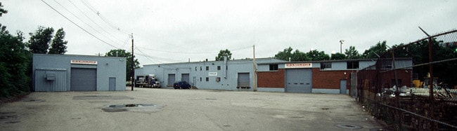

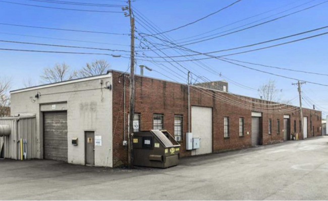
Property Detail
59 Clarendon St
WATE-001507-000005-000001
MIDDLESEX
Industrialgeneral
Massachusetts
I-2
1
B and X Area of moderate flood hazard, usually the area between the limits of the 100-year and 500-year floods.
2.51 AC
2024
Waltham/Watertown
2025
Boston
370202
Boston-Cambridge-Newton, MA-NH
NEARBY LISTINGS FOR SALE OR LEASE
DEMOGRAPHICS near 59 Clarendon St
1 mile
3 mile
5 mile
2025 Total Population
25,929
377,046
894,353
2030 Population
26,581
388,298
922,438
Pop Growth 2025-2030
+ 2.51%
+ 2.98%
+ 3.14%
Average Age
39
37
38
2025 Total Households
11,070
154,172
372,060
HH Growth 2025-2030
+ 2.78%
+ 3.38%
+ 3.45%
Median Household Inc
$112,846
$119,939
$117,681
Avg Household Size
2.20
2.10
2.10
2025 Avg HH Vehicles
1.00
1.00
1.00
Median Home Value
$809,102
$1,010,389
$956,834
Median Year Built
1949
1948
1949
Nearby Places
Map Layers
Map Styles
 Street
 Aerial
Layers
 Traffic
 Biking
Places
Listings with unknown addresses are not visible on the map
- Restaurants
- Banks
- Shops
- Fitness
- Groceries
PUBLIC TRANSPORTATION
COMMUTER RAIL
Waverley (Fitchburg/South Acton Line - Massachusetts Bay Transportation Authority Commuter Rail (Purple Line))
Drive
Walk
Distance
Waverley (Fitchburg/South Acton Line - Massachusetts Bay Transportation Authority Commuter Rail (Purple Line))
7 min
3.2 mi
Porter Square (Fitchburg/South Acton Line - Massachusetts Bay Transportation Authority Commuter Rail (Purple Line))
Drive
Walk
Distance
Porter Square (Fitchburg/South Acton Line - Massachusetts Bay Transportation Authority Commuter Rail (Purple Line))
8 min
3.6 mi
AIRPORT
General Edward Lawrence Logan International
Drive
Walk
Distance
General Edward Lawrence Logan International
19 min
9.5 mi
SALE & LEASE HISTORY
LISTING DATE
SALE/LEASE

Jun 06, 2025
For Lease
Nearby Properties
Address
Land Use
TOTAL SIZE
Lot Size
Zoning
Address
Land Use
TOTAL SIZE
Lot Size
Zoning
439,500 SF
9.21 AC
E
Address
Land Use
TOTAL SIZE
Lot Size
Zoning
125,571 SF
3.25 AC
C-3
Address
Land Use
TOTAL SIZE
Lot Size
Zoning
150,192 SF
10.27 AC
E
Address
Land Use
TOTAL SIZE
Lot Size
Zoning
530,200 SF
62.08 AC
E
Address
Land Use
TOTAL SIZE
Lot Size
Zoning
142,458 SF
1.67 AC
C-3
Address
Land Use
TOTAL SIZE
Lot Size
Zoning
304,349 SF
1.72 AC
Address
Land Use
TOTAL SIZE
Lot Size
Zoning
3.52 AC
C-3
Address
Land Use
TOTAL SIZE
Lot Size
Zoning
419,722 SF
2.03 AC
RC
Address
Land Use
TOTAL SIZE
Lot Size
Zoning
283,554 SF
2.76 AC
O-2A
Address
Land Use
TOTAL SIZE
Lot Size
Zoning
54,500 SF
4.01 AC
O-2A
Address
Land Use
TOTAL SIZE
Lot Size
Zoning
2.81 AC
O-2
Address
Land Use
TOTAL SIZE
Lot Size
Zoning
4,355 SF
13.12 AC
E
Address
Land Use
TOTAL SIZE
Lot Size
Zoning
336,518 SF
6.15 AC
I-3
Address
Land Use
TOTAL SIZE
Lot Size
Zoning
2.87 AC
O-2A
Address
Land Use
TOTAL SIZE
Lot Size
Zoning
155,818 SF
5.33 AC
OS
Address
Land Use
TOTAL SIZE
Lot Size
Zoning
220,671 SF
2.52 AC
I-2
Address
Land Use
TOTAL SIZE
Lot Size
Zoning
506,534 SF
2.75 AC
C
Address
Land Use
TOTAL SIZE
Lot Size
Zoning
213,834 SF
1.48 AC
SD-4
Address
Land Use
TOTAL SIZE
Lot Size
Zoning
136,025 SF
6.91 AC
C3
Address
Land Use
TOTAL SIZE
Lot Size
Zoning
2.25 AC
SD-12
Address
Land Use
TOTAL SIZE
Lot Size
Zoning
224,115 SF
2.35 AC
O-2A
Address
Land Use
TOTAL SIZE
Lot Size
Zoning
244,008 SF
4 AC
SD-4A
Address
Land Use
TOTAL SIZE
Lot Size
Zoning
174,764 SF
1.83 AC
C-3
Address
Land Use
TOTAL SIZE
Lot Size
Zoning
176,625 SF
5.76 AC
I-3
Address
Land Use
TOTAL SIZE
Lot Size
Zoning
443,356 SF
2.40 AC
C
Address
Land Use
TOTAL SIZE
Lot Size
Zoning
110,299 SF
0.82 AC
C-3
Address
Land Use
TOTAL SIZE
Lot Size
Zoning
91,500 SF
1.03 AC
SD-5
Address
Land Use
TOTAL SIZE
Lot Size
Zoning
241,130 SF
0.84 AC
CRDD
Address
Land Use
TOTAL SIZE
Lot Size
Zoning
208,468 SF
1.44 AC
RC
Address
Land Use
TOTAL SIZE
Lot Size
Zoning
268,675 SF
1.72 AC
I
The World's #1 Commercial Real Estate Marketplace
Connect with us
© 2026 CoStar Group
The information above has been obtained from sources believed reliable. While we do not doubt its accuracy we have not verified it and make no guarantee, warranty or representation about it. It is your responsibility to independently confirm its accuracy and completeness. Any projections, opinions, assumptions, or estimates used are for example only and do not represent the current or future performance of the property. The value of this transaction to you depends on tax and other factors which should be evaluated by your tax, financial, and legal advisors. You and your advisors should conduct a careful, independent investigation of the property to determine to your satisfaction the suitability of the property for your needs.