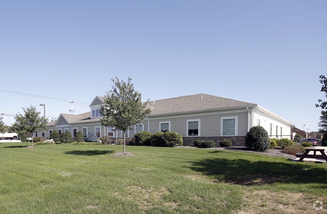
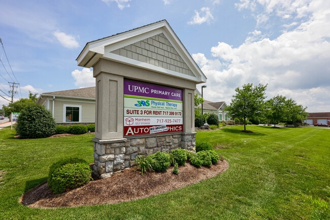
Property Record
80 Doe Run Rd, Manheim, PA 17545


Current Lease Availabilities
NEARBY LISTINGS FOR SALE OR LEASE
-
-
View all Manheim listings for lease on LoopNet.com
Property Detail
80 Doe Run Rd
Lancaster, PA
Add
500-09592-0-0000
60 DOE RUN RD
Officebuilding
Lancaster
X
Pennsylvania
42071C0142F
7
2024
1.40 AC
2025
Lancaster County
010302
Philadelphia
9,280 SF
DEMOGRAPHICS near 80 Doe Run Rd
1 Mile
3 Mile
5 Mile
2024 Total Population
6,351
16,278
46,431
2029 Population
6,403
16,362
46,813
Pop Growth 2024-2029
+ 0.82%
+ 0.52%
+ 0.82%
Average Age
41
41
43
2024 Total Households
2,569
6,270
17,999
HH Growth 2024-2029
+ 0.90%
+ 0.49%
+ 0.82%
Median Household Inc
$71,099
$73,950
$82,134
Avg Household Size
2.40
2.50
2.50
2024 Avg HH Vehicles
2.00
2.00
2.00
Median Home Value
$235,114
$250,737
$267,853
Median Year Built
1955
1970
1977
Nearby Places
Map Layers
Map Styles
 Street
 Aerial
- Restaurants
- Banks
- Shops
- Fitness
- Groceries
PUBLIC TRANSPORTATION
AIRPORT
Harrisburg International
DRIVE
WALK
Distance
Harrisburg International
36 min
26.9 mi
Freight Ports
Port Newark Container Terminal
DRIVE
WALK
Distance
Port Newark Container Terminal
95 min
59.2 mi
Nearby Properties
Address
Land Use
TOTAL SIZE
Lot Size
Zoning
Address
Land Use
TOTAL SIZE
Lot Size
Zoning
282,030 SF
107.20 AC
A
Address
Land Use
TOTAL SIZE
Lot Size
Zoning
398,438 SF
371.89 AC
LC
Address
Land Use
TOTAL SIZE
Lot Size
Zoning
282,030 SF
43.30 AC
R-3
Address
Land Use
TOTAL SIZE
Lot Size
Zoning
184,800 SF
32.10 AC
R-3
Address
Land Use
TOTAL SIZE
Lot Size
Zoning
227,046 SF
24.78 AC
Address
Land Use
TOTAL SIZE
Lot Size
Zoning
169 SF
2,253.50 AC
Address
Land Use
TOTAL SIZE
Lot Size
Zoning
234,006 SF
21.90 AC
R-1
Address
Land Use
TOTAL SIZE
Lot Size
Zoning
94,245 SF
111 AC
A
Address
Land Use
TOTAL SIZE
Lot Size
Zoning
86,489 SF
11.40 AC
CC
Address
Land Use
TOTAL SIZE
Lot Size
Zoning
97,541 SF
17.20 AC
CC
Address
Land Use
TOTAL SIZE
Lot Size
Zoning
77,094 SF
0.37 AC
R-3
Address
Land Use
TOTAL SIZE
Lot Size
Zoning
154,000 SF
21 AC
R-2
Address
Land Use
TOTAL SIZE
Lot Size
Zoning
56,982 SF
92.50 AC
A
Address
Land Use
TOTAL SIZE
Lot Size
Zoning
576 SF
18.21 AC
PC-1
Address
Land Use
TOTAL SIZE
Lot Size
Zoning
111,176 SF
14.80 AC
R-3
Address
Land Use
TOTAL SIZE
Lot Size
Zoning
121,697 SF
20.58 AC
Address
Land Use
TOTAL SIZE
Lot Size
Zoning
80,000 SF
7.85 AC
PC-1
Address
Land Use
TOTAL SIZE
Lot Size
Zoning
42,835 SF
2.80 AC
CC
Address
Land Use
TOTAL SIZE
Lot Size
Zoning
86,000 SF
5.57 AC
R-2
Address
Land Use
TOTAL SIZE
Lot Size
Zoning
20,970 SF
10 AC
Address
Land Use
TOTAL SIZE
Lot Size
Zoning
77,495 SF
6.85 AC
PC-1
Address
Land Use
TOTAL SIZE
Lot Size
Zoning
46,104 SF
135.30 AC
A
Address
Land Use
TOTAL SIZE
Lot Size
Zoning
2,160 SF
61.98 AC
R-2
Address
Land Use
TOTAL SIZE
Lot Size
Zoning
35,521 SF
0.94 AC
Address
Land Use
TOTAL SIZE
Lot Size
Zoning
76,079 SF
10.10 AC
I
Address
Land Use
TOTAL SIZE
Lot Size
Zoning
19,744 SF
2.38 AC
I
Address
Land Use
TOTAL SIZE
Lot Size
Zoning
2,644 SF
85.30 AC
A
Address
Land Use
TOTAL SIZE
Lot Size
Zoning
72,800 SF
6.90 AC
I
Address
Land Use
TOTAL SIZE
Lot Size
Zoning
108,000 SF
4.64 AC
PC-1
Address
Land Use
TOTAL SIZE
Lot Size
Zoning
67,321 SF
5.60 AC
I
The World's #1 Commercial Real Estate Marketplace
Connect with us
© 2026 CoStar Group
The information above has been obtained from sources believed reliable. While we do not doubt its accuracy we have not verified it and make no guarantee, warranty or representation about it. It is your responsibility to independently confirm its accuracy and completeness. Any projections, opinions, assumptions, or estimates used are for example only and do not represent the current or future performance of the property. The value of this transaction to you depends on tax and other factors which should be evaluated by your tax, financial, and legal advisors. You and your advisors should conduct a careful, independent investigation of the property to determine to your satisfaction the suitability of the property for your needs.