Property Record
80 E Main St, Avon, CT 06001
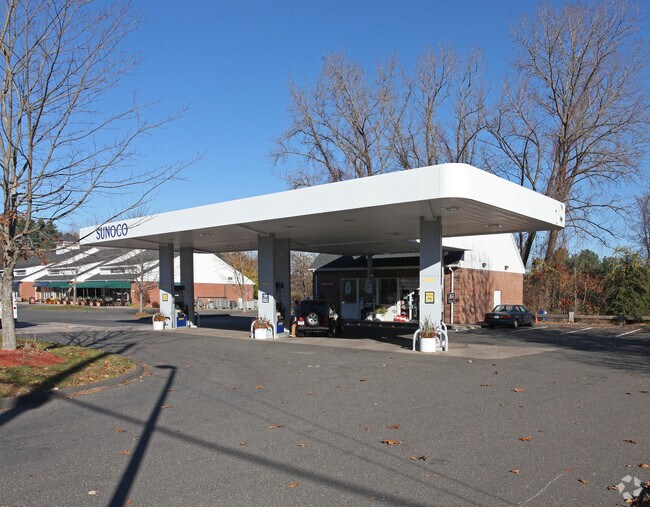

Property Detail
80 E Main St
AVON-000008-000000-000214-000080
HARTFORD
Commercialbuilding
Connecticut
CS
2140080
AE The base floodplain where base flood elevations are provided. AE Zones are now used on new format FIRMs instead of A1-A30 Zones.
0.69 AC
2025
Avon
2025
Hartford
462201
Hartford-West Hartford-East Hartford, CT
NEARBY LISTINGS FOR SALE OR LEASE
DEMOGRAPHICS near 80 E Main St
1 mile
3 mile
5 mile
2024 Total Population
3,035
19,895
76,940
2029 Population
3,112
20,392
78,765
Pop Growth 2024-2029
+ 2.54%
+ 2.50%
+ 2.37%
Average Age
46
43
44
2024 Total Households
1,309
7,844
30,927
HH Growth 2024-2029
+ 2.60%
+ 2.61%
+ 2.45%
Median Household Inc
$120,229
$143,059
$144,159
Avg Household Size
2.30
2.50
2.40
2024 Avg HH Vehicles
2.00
2.00
2.00
Median Home Value
$496,449
$462,087
$445,632
Median Year Built
1981
1975
1971
Nearby Places
Map Layers
Map Styles
 Street
 Aerial
Transit
 Traffic
 Biking
Places
Listings with unknown addresses are not visible on the map
- Restaurants
- Banks
- Shops
- Fitness
- Groceries
PUBLIC TRANSPORTATION
COMMUTER RAIL
Drive
Walk
Distance
15 min
8.7 mi
Drive
Walk
Distance
12 min
9.0 mi
AIRPORT
Bradley International
Drive
Walk
Distance
Bradley International
37 min
17.1 mi
SALE & LEASE HISTORY
LISTING DATE
SALE/LEASE

Jul 12, 2023
For Sale
Nearby Properties
Address
Land Use
TOTAL SIZE
Lot Size
Zoning
Address
Land Use
TOTAL SIZE
Lot Size
Zoning
39.86 AC
R40
Address
Land Use
TOTAL SIZE
Lot Size
Zoning
234.01 AC
EL
Address
Land Use
TOTAL SIZE
Lot Size
Zoning
35.44 AC
HSFBC
Address
Land Use
TOTAL SIZE
Lot Size
Zoning
26,928 SF
14.77 AC
PAD
Address
Land Use
TOTAL SIZE
Lot Size
Zoning
14.77 AC
R-40
Address
Land Use
TOTAL SIZE
Lot Size
Zoning
16.40 AC
B-3
Address
Land Use
TOTAL SIZE
Lot Size
Zoning
49,881 SF
18 AC
R-40
Address
Land Use
TOTAL SIZE
Lot Size
Zoning
18.52 AC
R40
Address
Land Use
TOTAL SIZE
Lot Size
Zoning
21.24 AC
R40
Address
Land Use
TOTAL SIZE
Lot Size
Zoning
5,640 SF
106.10 AC
R-40
Address
Land Use
TOTAL SIZE
Lot Size
Zoning
46.60 AC
RU2A
Address
Land Use
TOTAL SIZE
Lot Size
Zoning
121,561 SF
4.56 AC
HSFBC
Address
Land Use
TOTAL SIZE
Lot Size
Zoning
21.86 AC
Address
Land Use
TOTAL SIZE
Lot Size
Zoning
48.90 AC
R-80
Address
Land Use
TOTAL SIZE
Lot Size
Zoning
18.05 AC
CR
Address
Land Use
TOTAL SIZE
Lot Size
Zoning
10.91 AC
AVC
Address
Land Use
TOTAL SIZE
Lot Size
Zoning
13.08 AC
CR
Address
Land Use
TOTAL SIZE
Lot Size
Zoning
21.06 AC
B-3
Address
Land Use
TOTAL SIZE
Lot Size
Zoning
112,351 SF
27.57 AC
RD
Address
Land Use
TOTAL SIZE
Lot Size
Zoning
5.12 AC
Address
Land Use
TOTAL SIZE
Lot Size
Zoning
10 AC
RU2A
Address
Land Use
TOTAL SIZE
Lot Size
Zoning
6.57 AC
IP
Address
Land Use
TOTAL SIZE
Lot Size
Zoning
64,948 SF
9 AC
B-3
Address
Land Use
TOTAL SIZE
Lot Size
Zoning
20.11 AC
Address
Land Use
TOTAL SIZE
Lot Size
Zoning
4.02 AC
CP-A
Address
Land Use
TOTAL SIZE
Lot Size
Zoning
3.80 AC
Address
Land Use
TOTAL SIZE
Lot Size
Zoning
15.90 AC
R40
Address
Land Use
TOTAL SIZE
Lot Size
Zoning
126,889 SF
13.73 AC
I-1
Address
Land Use
TOTAL SIZE
Lot Size
Zoning
19.72 AC
RD
Address
Land Use
TOTAL SIZE
Lot Size
Zoning
8.73 AC
The World's #1 Commercial Real Estate Marketplace
Connect with us
© 2026 CoStar Group
The information above has been obtained from sources believed reliable. While we do not doubt its accuracy we have not verified it and make no guarantee, warranty or representation about it. It is your responsibility to independently confirm its accuracy and completeness. Any projections, opinions, assumptions, or estimates used are for example only and do not represent the current or future performance of the property. The value of this transaction to you depends on tax and other factors which should be evaluated by your tax, financial, and legal advisors. You and your advisors should conduct a careful, independent investigation of the property to determine to your satisfaction the suitability of the property for your needs.