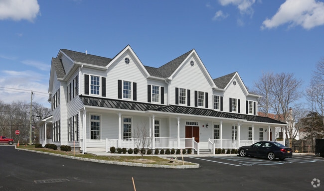
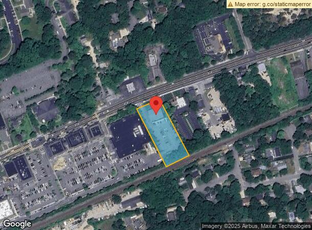
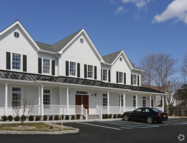
Property Record
80 E Montauk Hwy, Hampton Bays, NY 11946

NEARBY LISTINGS FOR SALE OR LEASE
Property Detail
80 E Montauk Hwy
0900-263-00-03-00-021-000
CAPTAINS TWO88 LD EQ+525CTR IMP-5250
Financialbuilding
Suffolk
X
New York
36103C0494H
21
0
1.23 AC
2024
Eastern Suffolk
190403
Long Island (New York)
10,169 SF
Nassau County-Suffolk County, NY
DEMOGRAPHICS near 80 E Montauk Hwy
1 Mile
3 Mile
5 Mile
2024 Total Population
7,248
22,191
30,821
2029 Population
7,375
22,869
31,811
Pop Growth 2024-2029
+ 1.75%
+ 3.06%
+ 3.21%
Average Age
41
42
42
2024 Total Households
2,581
8,226
11,501
HH Growth 2024-2029
+ 1.63%
+ 3.01%
+ 3.15%
Median Household Inc
$108,682
$113,628
$112,206
Avg Household Size
2.70
2.60
2.60
2024 Avg HH Vehicles
2.00
2.00
2.00
Median Home Value
$717,072
$726,476
$742,920
Median Year Built
1973
1974
1975
Nearby Places
- Restaurants
- Banks
- Shops
- Fitness
- Groceries
PUBLIC TRANSPORTATION
COMMUTER RAIL
Hampton Bays Station (Montauk Branch - Long Island Rail Road)
DRIVE
WALK
Distance
Hampton Bays Station (Montauk Branch - Long Island Rail Road)
2 min
7 min
0.4 mi
Southampton Station (Montauk Branch - Long Island Rail Road)
DRIVE
WALK
Distance
Southampton Station (Montauk Branch - Long Island Rail Road)
17 min
8.0 mi
AIRPORT
Long Island MacArthur
DRIVE
WALK
Distance
Long Island MacArthur
42 min
33.4 mi
Nearby Properties
Address
Land Use
TOTAL SIZE
Lot Size
Zoning
Address
Land Use
TOTAL SIZE
Lot Size
Zoning
16,677 SF
25.40 AC
R20
Address
Land Use
TOTAL SIZE
Lot Size
Zoning
47,996 SF
19.50 AC
R20
Address
Land Use
TOTAL SIZE
Lot Size
Zoning
200,320 SF
7.34 AC
MUPDD
Address
Land Use
TOTAL SIZE
Lot Size
Zoning
41 AC
IND-R
Address
Land Use
TOTAL SIZE
Lot Size
Zoning
2.64 AC
B3
Address
Land Use
TOTAL SIZE
Lot Size
Zoning
660,340 SF
8.50 AC
MF44
Address
Land Use
TOTAL SIZE
Lot Size
Zoning
23,691 SF
5.65 AC
MPDD
Address
Land Use
TOTAL SIZE
Lot Size
Zoning
70,960 SF
8.29 AC
SCB
Address
Land Use
TOTAL SIZE
Lot Size
Zoning
2,568 SF
17.10 AC
HB
Address
Land Use
TOTAL SIZE
Lot Size
Zoning
10,152 SF
0.80 AC
R15
Address
Land Use
TOTAL SIZE
Lot Size
Zoning
217 AC
H2O
Address
Land Use
TOTAL SIZE
Lot Size
Zoning
216.10 AC
H2O
Address
Land Use
TOTAL SIZE
Lot Size
Zoning
126,936 SF
41 AC
OSC
Address
Land Use
TOTAL SIZE
Lot Size
Zoning
16,249 SF
7.40 AC
R40
Address
Land Use
TOTAL SIZE
Lot Size
Zoning
13,448 SF
2.12 AC
R60
Address
Land Use
TOTAL SIZE
Lot Size
Zoning
238,520 SF
10.03 AC
SC44
Address
Land Use
TOTAL SIZE
Lot Size
Zoning
120,152 SF
20.50 AC
OSC
Address
Land Use
TOTAL SIZE
Lot Size
Zoning
67,796 SF
7 AC
SCB
Address
Land Use
TOTAL SIZE
Lot Size
Zoning
14,470 SF
4.20 AC
CR120
Address
Land Use
TOTAL SIZE
Lot Size
Zoning
46,793 SF
11.42 AC
HB
Address
Land Use
TOTAL SIZE
Lot Size
Zoning
19,542 SF
3.56 AC
R40
Address
Land Use
TOTAL SIZE
Lot Size
Zoning
26.70 AC
CR120
Address
Land Use
TOTAL SIZE
Lot Size
Zoning
11,520 SF
4.80 AC
RWB
Address
Land Use
TOTAL SIZE
Lot Size
Zoning
18.90 AC
R20
Address
Land Use
TOTAL SIZE
Lot Size
Zoning
13,129 SF
2 AC
VB
Address
Land Use
TOTAL SIZE
Lot Size
Zoning
30,140 SF
2.77 AC
VB
Address
Land Use
TOTAL SIZE
Lot Size
Zoning
27,154 SF
2.90 AC
HB
Address
Land Use
TOTAL SIZE
Lot Size
Zoning
19,399 SF
9.40 AC
R40
Address
Land Use
TOTAL SIZE
Lot Size
Zoning
36.50 AC
IND-R
Address
Land Use
TOTAL SIZE
Lot Size
Zoning
11,302 SF
1.60 AC
R40
The World's #1 Commercial Real Estate Marketplace
Connect with us
© 2025 CoStar Group
The information above has been obtained from sources believed reliable. While we do not doubt its accuracy we have not verified it and make no guarantee, warranty or representation about it. It is your responsibility to independently confirm its accuracy and completeness. Any projections, opinions, assumptions, or estimates used are for example only and do not represent the current or future performance of the property. The value of this transaction to you depends on tax and other factors which should be evaluated by your tax, financial, and legal advisors. You and your advisors should conduct a careful, independent investigation of the property to determine to your satisfaction the suitability of the property for your needs.