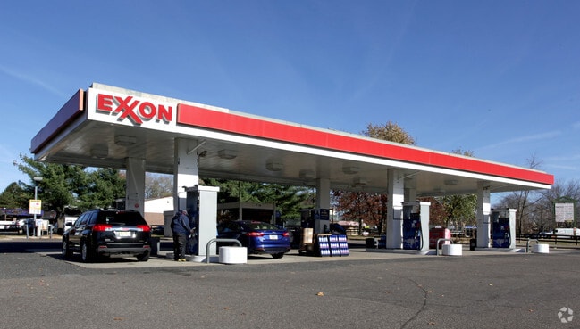
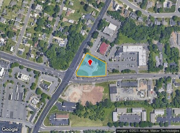
Property Record
80 Flock Rd, Trenton, NJ 08619

NEARBY LISTINGS FOR SALE OR LEASE
Property Detail
80 Flock Rd
Trenton-Princeton, NJ
Armando Palumbo
03-01551-0000-00017
01081-M
Servicestation
Mercer
X
New Jersey
34021C0231F
17
2024
1.16 AC
2025
Trenton
002902
Northern New Jersey
DEMOGRAPHICS near 80 Flock Rd
1 mile
3 mile
5 mile
2024 Total Population
7,311
61,256
224,256
2029 Population
7,160
60,146
220,887
Pop Growth 2024-2029
(2.07%)
(1.81%)
(1.50%)
Average Age
45
43
40
2024 Total Households
2,812
24,179
82,240
HH Growth 2024-2029
(2.24%)
(1.94%)
(1.58%)
Median Household Inc
$109,931
$99,687
$81,775
Avg Household Size
2.50
2.50
2.60
2024 Avg HH Vehicles
2.00
2.00
2.00
Median Home Value
$295,863
$295,660
$273,981
Median Year Built
1961
1968
1963
Nearby Places
Map Layers
Map Styles
 Street
 Aerial
Transit
 Traffic
 Biking
Places
Listings with unknown addresses are not visible on the map
- Restaurants
- Banks
- Shops
- Fitness
- Groceries
PUBLIC TRANSPORTATION
COMMUTER RAIL
Hamilton (Northeast Corridor Line - NJ Transit Commuter Rail (NJ Transit))
Drive
Walk
Distance
Hamilton (Northeast Corridor Line - NJ Transit Commuter Rail (NJ Transit))
4 min
1.3 mi
Drive
Walk
Distance
11 min
5.0 mi
AIRPORT
Trenton Mercer
Drive
Walk
Distance
Trenton Mercer
18 min
11.2 mi
Newark Liberty International
Drive
Walk
Distance
Newark Liberty International
70 min
49.1 mi
Freight Ports
Port of Philadelphia
Drive
Walk
Distance
Port of Philadelphia
51 min
34.6 mi
Nearby Properties
Address
Land Use
TOTAL SIZE
Lot Size
Zoning
Address
Land Use
TOTAL SIZE
Lot Size
Zoning
40.83 AC
E
Address
Land Use
TOTAL SIZE
Lot Size
Zoning
42.56 AC
RC
Address
Land Use
TOTAL SIZE
Lot Size
Zoning
19.63 AC
MX
Address
Land Use
TOTAL SIZE
Lot Size
Zoning
70.44 AC
MX-1
Address
Land Use
TOTAL SIZE
Lot Size
Zoning
Address
Land Use
TOTAL SIZE
Lot Size
Zoning
31.27 AC
LI
Address
Land Use
TOTAL SIZE
Lot Size
Zoning
56.45 AC
EGI
Address
Land Use
TOTAL SIZE
Lot Size
Zoning
27.13 AC
MX
Address
Land Use
TOTAL SIZE
Lot Size
Zoning
18.33 AC
Address
Land Use
TOTAL SIZE
Lot Size
Zoning
17.84 AC
HC
Address
Land Use
TOTAL SIZE
Lot Size
Zoning
Address
Land Use
TOTAL SIZE
Lot Size
Zoning
44.83 AC
I
Address
Land Use
TOTAL SIZE
Lot Size
Zoning
21.17 AC
I
Address
Land Use
TOTAL SIZE
Lot Size
Zoning
9.63 AC
RD
Address
Land Use
TOTAL SIZE
Lot Size
Zoning
16.45 AC
I-2
Address
Land Use
TOTAL SIZE
Lot Size
Zoning
27.50 AC
R7
Address
Land Use
TOTAL SIZE
Lot Size
Zoning
Address
Land Use
TOTAL SIZE
Lot Size
Zoning
47.84 AC
HC
Address
Land Use
TOTAL SIZE
Lot Size
Zoning
Address
Land Use
TOTAL SIZE
Lot Size
Zoning
15.80 AC
C
Address
Land Use
TOTAL SIZE
Lot Size
Zoning
28.36 AC
E
Address
Land Use
TOTAL SIZE
Lot Size
Zoning
Address
Land Use
TOTAL SIZE
Lot Size
Zoning
21.31 AC
RD-2
Address
Land Use
TOTAL SIZE
Lot Size
Zoning
Address
Land Use
TOTAL SIZE
Lot Size
Zoning
Address
Land Use
TOTAL SIZE
Lot Size
Zoning
Address
Land Use
TOTAL SIZE
Lot Size
Zoning
9.31 AC
HC
Address
Land Use
TOTAL SIZE
Lot Size
Zoning
16.62 AC
Address
Land Use
TOTAL SIZE
Lot Size
Zoning
14,574 SF
20.23 AC
R10
Address
Land Use
TOTAL SIZE
Lot Size
Zoning
The World's #1 Commercial Real Estate Marketplace
Connect with us
© 2026 CoStar Group
The information above has been obtained from sources believed reliable. While we do not doubt its accuracy we have not verified it and make no guarantee, warranty or representation about it. It is your responsibility to independently confirm its accuracy and completeness. Any projections, opinions, assumptions, or estimates used are for example only and do not represent the current or future performance of the property. The value of this transaction to you depends on tax and other factors which should be evaluated by your tax, financial, and legal advisors. You and your advisors should conduct a careful, independent investigation of the property to determine to your satisfaction the suitability of the property for your needs.