Property Record
80 Indian Rocks Rd S, Belleair Bluffs, FL 33770


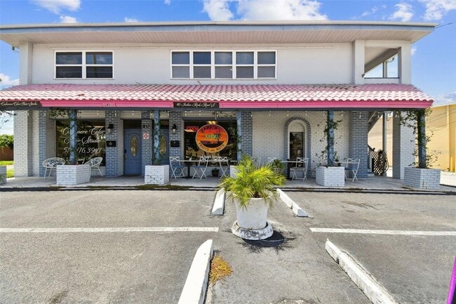
This Property Is For Sale
NEARBY LISTINGS FOR SALE OR LEASE
Property Detail
80 Indian Rocks Rd S
32-29-15-35640-002-0007
Harbor Bluffs Sec 1
Storesoffices
HARBOR BLUFFS SEC 1 BEG AT SE COR BLK B RUN NE 43FT NW 89.32FT W 24.65FT SW 88.76FT E 125FT TO POB
X
Pinellas
12103C0112H
Florida
2024
0.18 AC
2025
Mid-Pinellas
025210
Tampa/St Petersburg
4,045 SF
Tampa-St. Petersburg-Clearwater, FL
DEMOGRAPHICS near 80 Indian Rocks Rd S
1 Mile
3 Mile
5 Mile
2024 Total Population
9,838
81,027
195,024
2029 Population
9,838
82,237
196,796
Pop Growth 2024-2029
0.00%
+ 1.49%
+ 0.91%
Average Age
49
49
48
2024 Total Households
4,599
38,446
89,442
HH Growth 2024-2029
(0.15%)
+ 1.47%
+ 0.93%
Median Household Inc
$72,395
$61,070
$61,242
Avg Household Size
2.10
2.00
2.10
2024 Avg HH Vehicles
2.00
2.00
2.00
Median Home Value
$368,361
$311,278
$303,162
Median Year Built
1970
1975
1975
Nearby Places
Map Layers
Map Styles
 Street
 Aerial
- Restaurants
- Banks
- Shops
- Fitness
- Groceries
PUBLIC TRANSPORTATION
AIRPORT
St Pete-Clearwater International
DRIVE
WALK
Distance
St Pete-Clearwater International
17 min
8.2 mi
Tampa International
DRIVE
WALK
Distance
Tampa International
39 min
22.2 mi
Freight Ports
Port of Tampa Bay
DRIVE
WALK
Distance
Port of Tampa Bay
48 min
28.5 mi
Nearby Properties
Address
Land Use
TOTAL SIZE
Lot Size
Zoning
Address
Land Use
TOTAL SIZE
Lot Size
Zoning
839,480 SF
12.93 AC
Address
Land Use
TOTAL SIZE
Lot Size
Zoning
290,478 SF
15.95 AC
Address
Land Use
TOTAL SIZE
Lot Size
Zoning
537,958 SF
41.61 AC
C2
Address
Land Use
TOTAL SIZE
Lot Size
Zoning
529,506 SF
23.06 AC
Address
Land Use
TOTAL SIZE
Lot Size
Zoning
520,871 SF
29 AC
R6
Address
Land Use
TOTAL SIZE
Lot Size
Zoning
367,081 SF
13.80 AC
Address
Land Use
TOTAL SIZE
Lot Size
Zoning
333,425 SF
33.66 AC
Address
Land Use
TOTAL SIZE
Lot Size
Zoning
318,185 SF
38.78 AC
C2
Address
Land Use
TOTAL SIZE
Lot Size
Zoning
305,592 SF
9.65 AC
C2
Address
Land Use
TOTAL SIZE
Lot Size
Zoning
199,665 SF
4.80 AC
Address
Land Use
TOTAL SIZE
Lot Size
Zoning
509,129 SF
18.74 AC
Address
Land Use
TOTAL SIZE
Lot Size
Zoning
290,269 SF
8.49 AC
Address
Land Use
TOTAL SIZE
Lot Size
Zoning
321,140 SF
18.02 AC
Address
Land Use
TOTAL SIZE
Lot Size
Zoning
545,062 SF
8.37 AC
Address
Land Use
TOTAL SIZE
Lot Size
Zoning
294,101 SF
22.55 AC
Address
Land Use
TOTAL SIZE
Lot Size
Zoning
296,919 SF
39.10 AC
Address
Land Use
TOTAL SIZE
Lot Size
Zoning
198,688 SF
11.99 AC
Address
Land Use
TOTAL SIZE
Lot Size
Zoning
84,057 SF
34.26 AC
Address
Land Use
TOTAL SIZE
Lot Size
Zoning
129,600 SF
7.09 AC
Address
Land Use
TOTAL SIZE
Lot Size
Zoning
157,904 SF
0.57 AC
Address
Land Use
TOTAL SIZE
Lot Size
Zoning
186,391 SF
11.86 AC
Address
Land Use
TOTAL SIZE
Lot Size
Zoning
157,769 SF
4.47 AC
Address
Land Use
TOTAL SIZE
Lot Size
Zoning
283,033 SF
12.72 AC
Address
Land Use
TOTAL SIZE
Lot Size
Zoning
308,261 SF
5.62 AC
Address
Land Use
TOTAL SIZE
Lot Size
Zoning
152,088 SF
92.28 AC
PC
Address
Land Use
TOTAL SIZE
Lot Size
Zoning
213,918 SF
9.57 AC
Address
Land Use
TOTAL SIZE
Lot Size
Zoning
121,807 SF
17.23 AC
Address
Land Use
TOTAL SIZE
Lot Size
Zoning
102,073 SF
9.07 AC
Address
Land Use
TOTAL SIZE
Lot Size
Zoning
124,905 SF
13.91 AC
Address
Land Use
TOTAL SIZE
Lot Size
Zoning
92,317 SF
0.81 AC
The World's #1 Commercial Real Estate Marketplace
Connect with us
© 2026 CoStar Group
The information above has been obtained from sources believed reliable. While we do not doubt its accuracy we have not verified it and make no guarantee, warranty or representation about it. It is your responsibility to independently confirm its accuracy and completeness. Any projections, opinions, assumptions, or estimates used are for example only and do not represent the current or future performance of the property. The value of this transaction to you depends on tax and other factors which should be evaluated by your tax, financial, and legal advisors. You and your advisors should conduct a careful, independent investigation of the property to determine to your satisfaction the suitability of the property for your needs.