Property Record
80 Kentridge Dr, Kent City, MI 49330
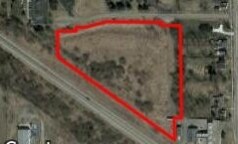
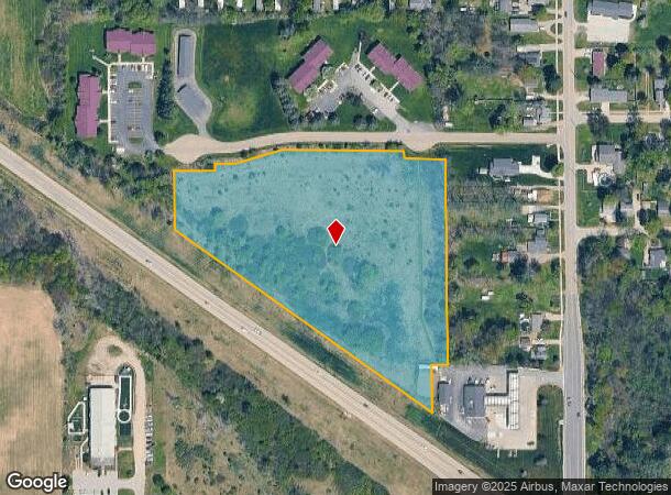
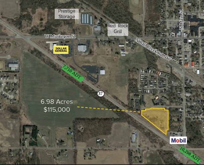

This Property Is For Sale
NEARBY LISTINGS FOR SALE OR LEASE
-
-
View all Kent City listings for sale on LoopNet.com
Property Detail
80 Kentridge Dr
41-01-32-276-033
410132276033 PART OF NE 1/4 COM 40.88 FT N 0D 42M 10S W ALONG E SEC LINE & 460.03 FT N 54D 39M 05S W ALONG NELY LINE OF STL
Commercialacreage
Kent
X
Michigan
26081C0134D
6.97 AC
2024
Outlying Kent County
2025
West Michigan
010301
Grand Rapids-Wyoming, MI
DEMOGRAPHICS near 80 Kentridge Dr
1 Mile
3 Mile
5 Mile
2024 Total Population
1,541
4,411
12,781
2029 Population
1,558
4,447
12,923
Pop Growth 2024-2029
+ 1.10%
+ 0.82%
+ 1.11%
Average Age
34
37
39
2024 Total Households
519
1,523
4,695
HH Growth 2024-2029
+ 0.96%
+ 0.79%
+ 1.21%
Median Household Inc
$63,000
$70,535
$69,900
Avg Household Size
3.00
2.90
2.70
2024 Avg HH Vehicles
2.00
2.00
2.00
Median Home Value
$199,999
$236,493
$233,975
Median Year Built
1983
1983
1977
Nearby Places
- Restaurants
- Banks
- Shops
- Fitness
- Groceries
PUBLIC TRANSPORTATION
AIRPORT
Gerald R Ford International
DRIVE
WALK
Distance
Gerald R Ford International
46 min
32.6 mi
Freight Ports
Port Milwaukee
DRIVE
WALK
Distance
Port Milwaukee
330 min
281.2 mi
Nearby Properties
Address
Land Use
TOTAL SIZE
Lot Size
Zoning
Address
Land Use
TOTAL SIZE
Lot Size
Zoning
2,293 SF
107.01 AC
A
Address
Land Use
TOTAL SIZE
Lot Size
Zoning
2,224 SF
20 AC
KCV R-3
Address
Land Use
TOTAL SIZE
Lot Size
Zoning
39,610 SF
11.81 AC
KCV I-1
Address
Land Use
TOTAL SIZE
Lot Size
Zoning
18,449 SF
5.71 AC
KCV C-2
Address
Land Use
TOTAL SIZE
Lot Size
Zoning
154,834 SF
34.92 AC
KCV I-1
Address
Land Use
TOTAL SIZE
Lot Size
Zoning
1,576 SF
20 AC
R-3
Address
Land Use
TOTAL SIZE
Lot Size
Zoning
900 SF
15.23 AC
R-3
Address
Land Use
TOTAL SIZE
Lot Size
Zoning
27,172 SF
2.95 AC
KCV R-2
Address
Land Use
TOTAL SIZE
Lot Size
Zoning
39,000 SF
6.22 AC
KCV C-2
Address
Land Use
TOTAL SIZE
Lot Size
Zoning
1,442 SF
154.37 AC
AG1
Address
Land Use
TOTAL SIZE
Lot Size
Zoning
1,442 SF
91.46 AC
A
Address
Land Use
TOTAL SIZE
Lot Size
Zoning
4,432 SF
20 AC
AG1
Address
Land Use
TOTAL SIZE
Lot Size
Zoning
24,400 SF
4.01 AC
I
Address
Land Use
TOTAL SIZE
Lot Size
Zoning
2,121 SF
90 AC
A1
Address
Land Use
TOTAL SIZE
Lot Size
Zoning
64,880 SF
5.27 AC
I
Address
Land Use
TOTAL SIZE
Lot Size
Zoning
1,591 SF
168.61 AC
AG1
Address
Land Use
TOTAL SIZE
Lot Size
Zoning
3,071 SF
40 AC
AG1
Address
Land Use
TOTAL SIZE
Lot Size
Zoning
21,224 SF
2.80 AC
KCV R-2
Address
Land Use
TOTAL SIZE
Lot Size
Zoning
1,438 SF
154.13 AC
AG2
Address
Land Use
TOTAL SIZE
Lot Size
Zoning
1,576 SF
75.53 AC
A
Address
Land Use
TOTAL SIZE
Lot Size
Zoning
2,309 SF
78.30 AC
AG1
Address
Land Use
TOTAL SIZE
Lot Size
Zoning
3,852 SF
78.54 AC
RA
Address
Land Use
TOTAL SIZE
Lot Size
Zoning
2,572 SF
38.48 AC
AG1
Address
Land Use
TOTAL SIZE
Lot Size
Zoning
24,950 SF
2.33 AC
KCV I-1
Address
Land Use
TOTAL SIZE
Lot Size
Zoning
1,104 SF
111.35 AC
A
Address
Land Use
TOTAL SIZE
Lot Size
Zoning
11,900 SF
1.30 AC
KCV C-2
Address
Land Use
TOTAL SIZE
Lot Size
Zoning
2,332 SF
118.16 AC
A
Address
Land Use
TOTAL SIZE
Lot Size
Zoning
2,368 SF
109.66 AC
AGRICULTUR
Address
Land Use
TOTAL SIZE
Lot Size
Zoning
1,848 SF
40 AC
AG1
Address
Land Use
TOTAL SIZE
Lot Size
Zoning
2,396 SF
77.08 AC
AG1
The World's #1 Commercial Real Estate Marketplace
Connect with us
© 2025 CoStar Group
The information above has been obtained from sources believed reliable. While we do not doubt its accuracy we have not verified it and make no guarantee, warranty or representation about it. It is your responsibility to independently confirm its accuracy and completeness. Any projections, opinions, assumptions, or estimates used are for example only and do not represent the current or future performance of the property. The value of this transaction to you depends on tax and other factors which should be evaluated by your tax, financial, and legal advisors. You and your advisors should conduct a careful, independent investigation of the property to determine to your satisfaction the suitability of the property for your needs.