Property Record
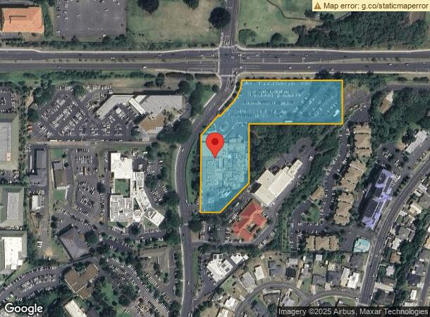
80 Mahalani Rd, Kahului, HI 96732
NEARBY LISTINGS FOR SALE OR LEASE
Property Detail
80 Mahalani Rd
Kahului-Wailuku-Lahaina, HI
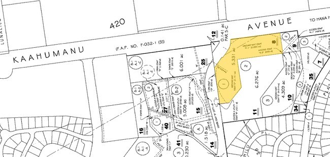
Kaiser Medical Clinic Subd
2-3-8-046-008-0000
LOT 1 KAISER MEDICAL CLINIC SUBD POR RP 4475 LCAW 7713:23 RP 1996 LCAW 420 5.331 AC DES SUBJ/ESMTS NO DES
Commercialnec
Maui
X
Hawaii
1500030392E
1
2024
5.33 AC
2025
Central Maui
031900
Hawaii
71,177 SF
DEMOGRAPHICS near 80 Mahalani Rd
1 Mile
3 Mile
5 Mile
2024 Total Population
15,849
52,821
54,102
2029 Population
15,487
51,817
53,060
Pop Growth 2024-2029
(2.28%)
(1.90%)
(1.93%)
Average Age
42
40
40
2024 Total Households
4,866
15,312
15,660
HH Growth 2024-2029
(3.02%)
(2.53%)
(2.55%)
Median Household Inc
$63,130
$81,093
$81,435
Avg Household Size
2.90
3.20
3.20
2024 Avg HH Vehicles
2.00
2.00
2.00
Median Home Value
$617,255
$674,517
$672,500
Median Year Built
1976
1986
1986
Nearby Places
Map Layers
Map Styles
 Street
 Aerial
- Restaurants
- Banks
- Shops
- Fitness
- Groceries
PUBLIC TRANSPORTATION
AIRPORT
Kahului
DRIVE
WALK
Distance
Kahului
14 min
5.7 mi
Nearby Properties
Address
Land Use
TOTAL SIZE
Lot Size
Zoning
Address
Land Use
TOTAL SIZE
Lot Size
Zoning
14.34 AC
500
Address
Land Use
TOTAL SIZE
Lot Size
Zoning
191,252 SF
25.37 AC
420
Address
Land Use
TOTAL SIZE
Lot Size
Zoning
141,663 SF
11.88 AC
Address
Land Use
TOTAL SIZE
Lot Size
Zoning
43,434 SF
13.89 AC
410
Address
Land Use
TOTAL SIZE
Lot Size
Zoning
130,920 SF
11.42 AC
Address
Land Use
TOTAL SIZE
Lot Size
Zoning
153,273 SF
10.95 AC
Address
Land Use
TOTAL SIZE
Lot Size
Zoning
149,380 SF
12.84 AC
420
Address
Land Use
TOTAL SIZE
Lot Size
Zoning
144,519 SF
12.99 AC
410
Address
Land Use
TOTAL SIZE
Lot Size
Zoning
103,221 SF
12.93 AC
720
Address
Land Use
TOTAL SIZE
Lot Size
Zoning
234,826 SF
14.36 AC
410
Address
Land Use
TOTAL SIZE
Lot Size
Zoning
25,358 SF
9.88 AC
Address
Land Use
TOTAL SIZE
Lot Size
Zoning
4.10 AC
410
Address
Land Use
TOTAL SIZE
Lot Size
Zoning
56,906 SF
8.69 AC
410
Address
Land Use
TOTAL SIZE
Lot Size
Zoning
79,284 SF
3.35 AC
215
Address
Land Use
TOTAL SIZE
Lot Size
Zoning
94,821 SF
7.30 AC
420
Address
Land Use
TOTAL SIZE
Lot Size
Zoning
5.11 AC
Address
Land Use
TOTAL SIZE
Lot Size
Zoning
19.54 AC
720
Address
Land Use
TOTAL SIZE
Lot Size
Zoning
72,457 SF
2.96 AC
320
Address
Land Use
TOTAL SIZE
Lot Size
Zoning
24,848 SF
11.41 AC
500
Address
Land Use
TOTAL SIZE
Lot Size
Zoning
552,589 SF
24.60 AC
420
Address
Land Use
TOTAL SIZE
Lot Size
Zoning
81,702 SF
4.40 AC
Address
Land Use
TOTAL SIZE
Lot Size
Zoning
72,377 SF
6.06 AC
720
Address
Land Use
TOTAL SIZE
Lot Size
Zoning
1.83 AC
Address
Land Use
TOTAL SIZE
Lot Size
Zoning
16.75 AC
320
Address
Land Use
TOTAL SIZE
Lot Size
Zoning
12.49 AC
Address
Land Use
TOTAL SIZE
Lot Size
Zoning
94,025 SF
0.84 AC
370
Address
Land Use
TOTAL SIZE
Lot Size
Zoning
103,520 SF
4.50 AC
720
Address
Land Use
TOTAL SIZE
Lot Size
Zoning
2.01 AC
Address
Land Use
TOTAL SIZE
Lot Size
Zoning
42,501 SF
2.59 AC
420
The World's #1 Commercial Real Estate Marketplace
Connect with us
© 2026 CoStar Group
The information above has been obtained from sources believed reliable. While we do not doubt its accuracy we have not verified it and make no guarantee, warranty or representation about it. It is your responsibility to independently confirm its accuracy and completeness. Any projections, opinions, assumptions, or estimates used are for example only and do not represent the current or future performance of the property. The value of this transaction to you depends on tax and other factors which should be evaluated by your tax, financial, and legal advisors. You and your advisors should conduct a careful, independent investigation of the property to determine to your satisfaction the suitability of the property for your needs.