Property Record
80 N High St, Greenville, PA 16125

NEARBY LISTINGS FOR SALE OR LEASE
-
-
View all Greenville listings for sale on LoopNet.com
Property Detail
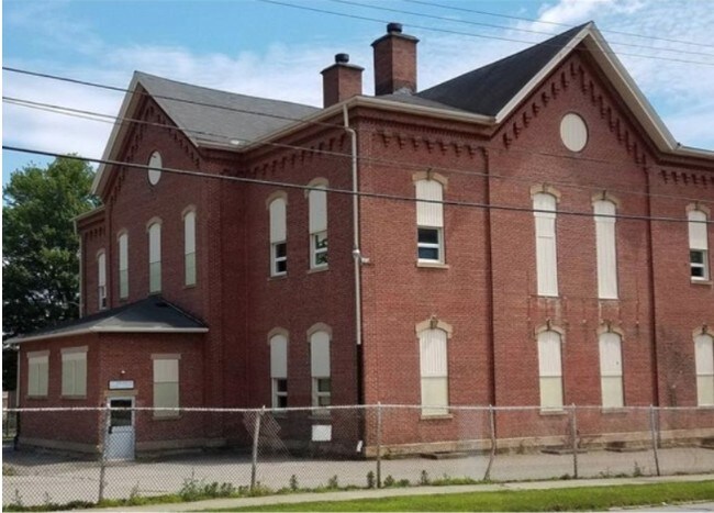
80 N High St
55-500-071
CHURCH
Taxexempt
Mercer
X
Pennsylvania
42085C0042D
0.54 AC
2025
Mercer County
2025
Youngstown/Warren/Boardman
032200
Hermitage, PA
DEMOGRAPHICS near 80 N High St
1 Mile
3 Mile
5 Mile
2024 Total Population
4,691
10,968
15,438
2029 Population
4,686
10,834
15,266
Pop Growth 2024-2029
(0.11%)
(1.22%)
(1.11%)
Average Age
40
44
44
2024 Total Households
1,872
4,482
6,381
HH Growth 2024-2029
+ 0.21%
(1.16%)
(1.08%)
Median Household Inc
$51,773
$55,741
$55,347
Avg Household Size
2.10
2.10
2.20
2024 Avg HH Vehicles
1.00
2.00
2.00
Median Home Value
$85,948
$124,166
$134,542
Median Year Built
1948
1954
1958
Nearby Places
Map Layers
Map Styles
 Street
 Aerial
- Restaurants
- Banks
- Shops
- Fitness
- Groceries
SALE & LEASE HISTORY
LISTING DATE
SALE/LEASE

Oct 27, 2017
For Sale
Nearby Properties
Address
Land Use
TOTAL SIZE
Lot Size
Zoning
Address
Land Use
TOTAL SIZE
Lot Size
Zoning
Address
Land Use
TOTAL SIZE
Lot Size
Zoning
Address
Land Use
TOTAL SIZE
Lot Size
Zoning
4.70 AC
Address
Land Use
TOTAL SIZE
Lot Size
Zoning
12.85 AC
Address
Land Use
TOTAL SIZE
Lot Size
Zoning
10.75 AC
Address
Land Use
TOTAL SIZE
Lot Size
Zoning
544.67 AC
Address
Land Use
TOTAL SIZE
Lot Size
Zoning
Address
Land Use
TOTAL SIZE
Lot Size
Zoning
155,404 SF
22.24 AC
Address
Land Use
TOTAL SIZE
Lot Size
Zoning
120 AC
Address
Land Use
TOTAL SIZE
Lot Size
Zoning
1.72 AC
Address
Land Use
TOTAL SIZE
Lot Size
Zoning
6.53 AC
Address
Land Use
TOTAL SIZE
Lot Size
Zoning
5.09 AC
Address
Land Use
TOTAL SIZE
Lot Size
Zoning
23.07 AC
Address
Land Use
TOTAL SIZE
Lot Size
Zoning
0.74 AC
Address
Land Use
TOTAL SIZE
Lot Size
Zoning
1,584 SF
21.62 AC
Address
Land Use
TOTAL SIZE
Lot Size
Zoning
80 AC
Address
Land Use
TOTAL SIZE
Lot Size
Zoning
Address
Land Use
TOTAL SIZE
Lot Size
Zoning
30,250 SF
3.72 AC
Address
Land Use
TOTAL SIZE
Lot Size
Zoning
6.03 AC
Address
Land Use
TOTAL SIZE
Lot Size
Zoning
0.56 AC
Address
Land Use
TOTAL SIZE
Lot Size
Zoning
23,400 SF
1.16 AC
Address
Land Use
TOTAL SIZE
Lot Size
Zoning
0.50 AC
Address
Land Use
TOTAL SIZE
Lot Size
Zoning
52.63 AC
Address
Land Use
TOTAL SIZE
Lot Size
Zoning
14,400 SF
Address
Land Use
TOTAL SIZE
Lot Size
Zoning
0.39 AC
Address
Land Use
TOTAL SIZE
Lot Size
Zoning
Address
Land Use
TOTAL SIZE
Lot Size
Zoning
0.86 AC
Address
Land Use
TOTAL SIZE
Lot Size
Zoning
3,200 SF
Address
Land Use
TOTAL SIZE
Lot Size
Zoning
0.41 AC
Address
Land Use
TOTAL SIZE
Lot Size
Zoning
9,680 SF
5.74 AC
The World's #1 Commercial Real Estate Marketplace
Connect with us
© 2026 CoStar Group
The information above has been obtained from sources believed reliable. While we do not doubt its accuracy we have not verified it and make no guarantee, warranty or representation about it. It is your responsibility to independently confirm its accuracy and completeness. Any projections, opinions, assumptions, or estimates used are for example only and do not represent the current or future performance of the property. The value of this transaction to you depends on tax and other factors which should be evaluated by your tax, financial, and legal advisors. You and your advisors should conduct a careful, independent investigation of the property to determine to your satisfaction the suitability of the property for your needs.