No Photo
Property Record
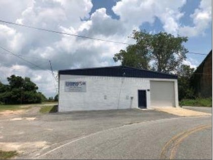
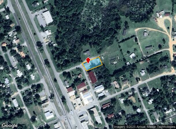
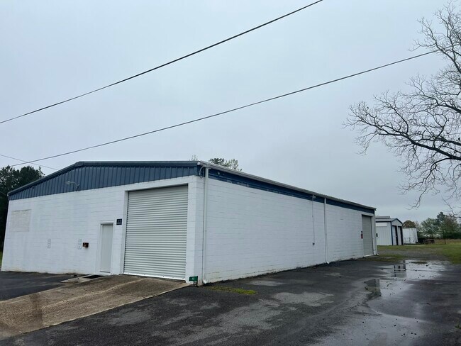
80 N Labelle Ave, Sycamore, GA 31790
NEARBY LISTINGS FOR SALE OR LEASE
Property Detail
80 N Labelle Ave
S04-075A
LD2 BLK 3 LOT 9-PT10 TR D PLAT B16 .46AC
Commercialnec
Turner
X
Georgia
13287C0145A
9,10
2024
0.46 AC
2024
Georgia South Area
970300
Other Market Areas
3,840 SF
Tifton, GA
DEMOGRAPHICS near 80 N Labelle Ave
1 mile
3 mile
5 mile
2024 Total Population
836
5,390
6,824
2029 Population
814
5,274
6,672
Pop Growth 2024-2029
(2.63%)
(2.15%)
(2.23%)
Average Age
39
40
40
2024 Total Households
244
2,039
2,619
HH Growth 2024-2029
(3.28%)
(2.21%)
(2.25%)
Median Household Inc
$48,076
$32,877
$33,999
Avg Household Size
2.60
2.40
2.40
2024 Avg HH Vehicles
2.00
2.00
2.00
Median Home Value
$61,071
$79,481
$84,463
Median Year Built
1971
1973
1973
Nearby Places
Map Layers
Map Styles
 Street
 Aerial
Transit
 Traffic
 Biking
Places
Listings with unknown addresses are not visible on the map
- Restaurants
- Banks
- Shops
- Fitness
- Groceries
PUBLIC TRANSPORTATION
AIRPORT
Southwest Georgia Regional
Drive
Walk
Distance
Southwest Georgia Regional
68 min
43.5 mi
SALE & LEASE HISTORY
LISTING DATE
SALE/LEASE

Sep 24, 2021
For Sale
Mar 11, 2025
For Sale
Aug 01, 2018
For Sale
Apr 04, 2024
For Sale
Nearby Properties
Address
Land Use
TOTAL SIZE
Lot Size
Zoning
Address
Land Use
TOTAL SIZE
Lot Size
Zoning
173,518 SF
21.43 AC
003
Address
Land Use
TOTAL SIZE
Lot Size
Zoning
844 SF
28.50 AC
002
Address
Land Use
TOTAL SIZE
Lot Size
Zoning
4,610 SF
12.71 AC
002
Address
Land Use
TOTAL SIZE
Lot Size
Zoning
3,600 SF
65.60 AC
007
Address
Land Use
TOTAL SIZE
Lot Size
Zoning
4,132 SF
12.95 AC
007
Address
Land Use
TOTAL SIZE
Lot Size
Zoning
39,456 SF
6.86 AC
005
Address
Land Use
TOTAL SIZE
Lot Size
Zoning
43,750 SF
12.08 AC
002
Address
Land Use
TOTAL SIZE
Lot Size
Zoning
144,000 SF
6.14 AC
002
Address
Land Use
TOTAL SIZE
Lot Size
Zoning
45,800 SF
10 AC
007
Address
Land Use
TOTAL SIZE
Lot Size
Zoning
59,500 SF
4.97 AC
007
Address
Land Use
TOTAL SIZE
Lot Size
Zoning
2.10 AC
001
Address
Land Use
TOTAL SIZE
Lot Size
Zoning
13,553 SF
12.08 AC
003
Address
Land Use
TOTAL SIZE
Lot Size
Zoning
2,050 SF
4.92 AC
002
Address
Land Use
TOTAL SIZE
Lot Size
Zoning
112,493 SF
10 AC
002
Address
Land Use
TOTAL SIZE
Lot Size
Zoning
1,539 SF
13.55 AC
003
Address
Land Use
TOTAL SIZE
Lot Size
Zoning
2,834 SF
13.10 AC
002
Address
Land Use
TOTAL SIZE
Lot Size
Zoning
30,426 SF
4.97 AC
002
Address
Land Use
TOTAL SIZE
Lot Size
Zoning
17.35 AC
001
Address
Land Use
TOTAL SIZE
Lot Size
Zoning
2,146 SF
3.67 AC
002
Address
Land Use
TOTAL SIZE
Lot Size
Zoning
40,800 SF
8.60 AC
002
Address
Land Use
TOTAL SIZE
Lot Size
Zoning
1,200 SF
450 AC
007
Address
Land Use
TOTAL SIZE
Lot Size
Zoning
15,000 SF
4.04 AC
003
Address
Land Use
TOTAL SIZE
Lot Size
Zoning
8,958 SF
8.66 AC
002
Address
Land Use
TOTAL SIZE
Lot Size
Zoning
32,500 SF
12.94 AC
003
Address
Land Use
TOTAL SIZE
Lot Size
Zoning
1.66 AC
001
Address
Land Use
TOTAL SIZE
Lot Size
Zoning
487.69 AC
004
Address
Land Use
TOTAL SIZE
Lot Size
Zoning
7,875 SF
2.05 AC
002
Address
Land Use
TOTAL SIZE
Lot Size
Zoning
15,400 SF
1.37 AC
002
Address
Land Use
TOTAL SIZE
Lot Size
Zoning
19,408 SF
4.79 AC
002
Address
Land Use
TOTAL SIZE
Lot Size
Zoning
4.82 AC
001
The World's #1 Commercial Real Estate Marketplace
Connect with us
© 2026 CoStar Group
The information above has been obtained from sources believed reliable. While we do not doubt its accuracy we have not verified it and make no guarantee, warranty or representation about it. It is your responsibility to independently confirm its accuracy and completeness. Any projections, opinions, assumptions, or estimates used are for example only and do not represent the current or future performance of the property. The value of this transaction to you depends on tax and other factors which should be evaluated by your tax, financial, and legal advisors. You and your advisors should conduct a careful, independent investigation of the property to determine to your satisfaction the suitability of the property for your needs.