Property Record
80 Pine Valley Rd, Hiram, GA 30141


Property Detail
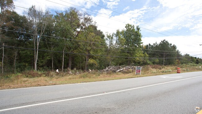
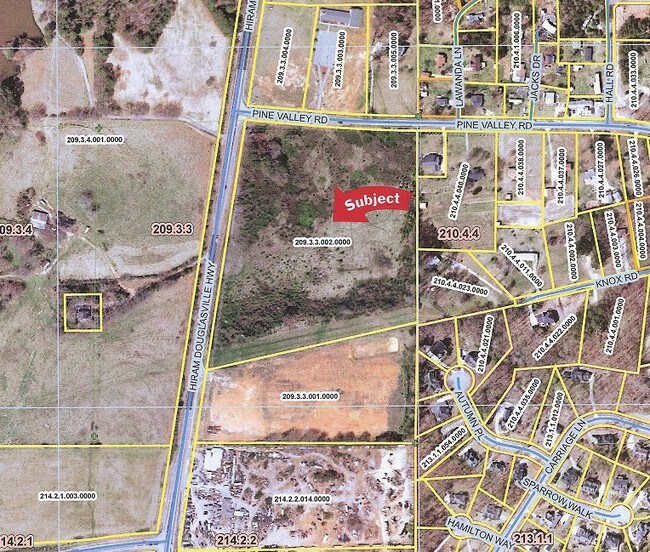
80 Pine Valley Rd
209.3.3.002.0000
REAL PROPERTY
Warehouse
PAULDING
I1
Georgia
B and X Area of moderate flood hazard, usually the area between the limits of the 100-year and 500-year floods.
1048
2025
7.35 AC
2025
Villa Rica/West Outlying
120603
Atlanta
69,232 SF
Atlanta-Sandy Springs-Roswell, GA
NEARBY LISTINGS FOR SALE OR LEASE
DEMOGRAPHICS near 80 Pine Valley Rd
1 mile
3 mile
5 mile
2025 Total Population
2,124
25,767
88,258
2030 Population
2,313
27,739
94,436
Pop Growth 2025-2030
+ 8.90%
+ 7.65%
+ 7.00%
Average Age
40
39
39
2025 Total Households
719
9,005
30,529
HH Growth 2025-2030
+ 8.90%
+ 7.71%
+ 7.10%
Median Household Inc
$92,865
$94,191
$96,137
Avg Household Size
2.80
2.80
2.80
2025 Avg HH Vehicles
2.00
2.00
2.00
Median Home Value
$302,674
$310,832
$315,606
Median Year Built
1994
1996
1997
Nearby Places
Map Layers
Map Styles
 Street
 Aerial
Layers
 Traffic
 Biking
Places
Listings with unknown addresses are not visible on the map
- Restaurants
- Banks
- Shops
- Fitness
- Groceries
PUBLIC TRANSPORTATION
AIRPORT
Hartsfield - Jackson Atlanta International
Drive
Walk
Distance
Hartsfield - Jackson Atlanta International
50 min
36.0 mi
Freight Ports
Georgia Ports - Savannah
Drive
Walk
Distance
Georgia Ports - Savannah
313 min
275.3 mi
SALE & LEASE HISTORY
LISTING DATE
SALE/LEASE

Oct 19, 2018
For Sale
Nearby Properties
Address
Land Use
TOTAL SIZE
Lot Size
Zoning
Address
Land Use
TOTAL SIZE
Lot Size
Zoning
69.17 AC
Address
Land Use
TOTAL SIZE
Lot Size
Zoning
15.02 AC
Address
Land Use
TOTAL SIZE
Lot Size
Zoning
77.25 AC
A1
Address
Land Use
TOTAL SIZE
Lot Size
Zoning
Address
Land Use
TOTAL SIZE
Lot Size
Zoning
21.05 AC
Address
Land Use
TOTAL SIZE
Lot Size
Zoning
25.34 AC
Address
Land Use
TOTAL SIZE
Lot Size
Zoning
141,658 SF
17.36 AC
PSC
Address
Land Use
TOTAL SIZE
Lot Size
Zoning
27.55 AC
Address
Land Use
TOTAL SIZE
Lot Size
Zoning
171,184 SF
14.63 AC
PSC
Address
Land Use
TOTAL SIZE
Lot Size
Zoning
185,183 SF
6.99 AC
OI
Address
Land Use
TOTAL SIZE
Lot Size
Zoning
86,556 SF
8.10 AC
PSC
Address
Land Use
TOTAL SIZE
Lot Size
Zoning
57,600 SF
2.91 AC
PSC
Address
Land Use
TOTAL SIZE
Lot Size
Zoning
42,320 SF
4.67 AC
PSC
Address
Land Use
TOTAL SIZE
Lot Size
Zoning
101,703 SF
8.95 AC
B2
Address
Land Use
TOTAL SIZE
Lot Size
Zoning
43,002 SF
7.01 AC
PSC
Address
Land Use
TOTAL SIZE
Lot Size
Zoning
52,320 SF
10 AC
Address
Land Use
TOTAL SIZE
Lot Size
Zoning
82,765 SF
8.51 AC
B2
Address
Land Use
TOTAL SIZE
Lot Size
Zoning
221.39 AC
Address
Land Use
TOTAL SIZE
Lot Size
Zoning
1.90 AC
Address
Land Use
TOTAL SIZE
Lot Size
Zoning
10,662 SF
1.12 AC
PSC-100
Address
Land Use
TOTAL SIZE
Lot Size
Zoning
134,860 SF
58.90 AC
I1
Address
Land Use
TOTAL SIZE
Lot Size
Zoning
71,982 SF
5.23 AC
I1
Address
Land Use
TOTAL SIZE
Lot Size
Zoning
14,946 SF
23.44 AC
Address
Land Use
TOTAL SIZE
Lot Size
Zoning
67,982 SF
4.31 AC
B2
Address
Land Use
TOTAL SIZE
Lot Size
Zoning
74,300 SF
4.47 AC
I1
Address
Land Use
TOTAL SIZE
Lot Size
Zoning
0.54 AC
Address
Land Use
TOTAL SIZE
Lot Size
Zoning
3,084 SF
284.96 AC
B1-1;PRD-9
Address
Land Use
TOTAL SIZE
Lot Size
Zoning
12.93 AC
The World's #1 Commercial Real Estate Marketplace
Connect with us
© 2026 CoStar Group
The information above has been obtained from sources believed reliable. While we do not doubt its accuracy we have not verified it and make no guarantee, warranty or representation about it. It is your responsibility to independently confirm its accuracy and completeness. Any projections, opinions, assumptions, or estimates used are for example only and do not represent the current or future performance of the property. The value of this transaction to you depends on tax and other factors which should be evaluated by your tax, financial, and legal advisors. You and your advisors should conduct a careful, independent investigation of the property to determine to your satisfaction the suitability of the property for your needs.