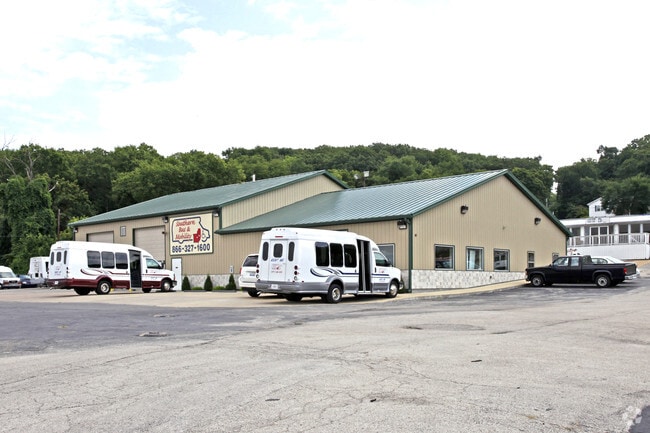
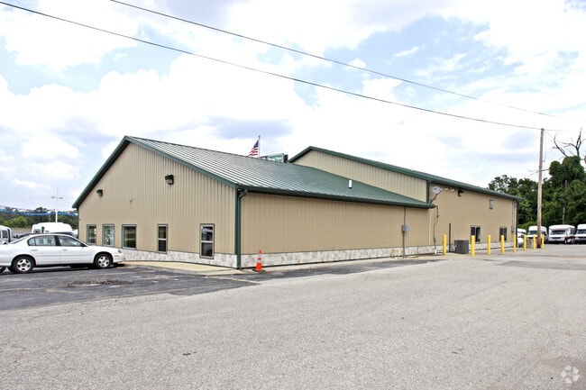
Property Record
80 S Highway Dr, Valley Park, MO 63088

Current Lease Availabilities
NEARBY LISTINGS FOR SALE OR LEASE
Property Detail
80 S Highway Dr
St. Louis, MO-IL
J E Roques
27Q-64-0616
J E ROQUES LOT PTS 166 & 167 & MERAMEC ST VAC PT (8094 1508) & DETERDIN GST VAC PT (7735 473)
Vehiclerentalsvehiclesales
St. Louis
AE
Missouri
29099C0050F
166-1
2024
1.45 AC
2025
Fenton
221426
St. Louis
6,000 SF
DEMOGRAPHICS near 80 S Highway Dr
1 Mile
3 Mile
5 Mile
2024 Total Population
4,539
49,659
129,502
2029 Population
4,406
48,471
127,753
Pop Growth 2024-2029
(2.93%)
(2.39%)
(1.35%)
Average Age
42
41
42
2024 Total Households
1,820
20,167
51,688
HH Growth 2024-2029
(2.97%)
(2.41%)
(1.32%)
Median Household Inc
$101,664
$90,720
$93,914
Avg Household Size
2.50
2.40
2.50
2024 Avg HH Vehicles
2.00
2.00
2.00
Median Home Value
$275,858
$284,287
$294,697
Median Year Built
1988
1983
1980
Nearby Places
Map Layers
Map Styles
 Street
 Aerial
- Restaurants
- Banks
- Shops
- Fitness
- Groceries
PUBLIC TRANSPORTATION
COMMUTER RAIL
DRIVE
WALK
Distance
12 min
6.9 mi
AIRPORT
St Louis Lambert International
DRIVE
WALK
Distance
St Louis Lambert International
34 min
22.1 mi
Nearby Properties
Address
Land Use
TOTAL SIZE
Lot Size
Zoning
Address
Land Use
TOTAL SIZE
Lot Size
Zoning
429,212 SF
53.13 AC
C-8
Address
Land Use
TOTAL SIZE
Lot Size
Zoning
96.62 AC
R3
Address
Land Use
TOTAL SIZE
Lot Size
Zoning
862,067 SF
40.98 AC
C-8
Address
Land Use
TOTAL SIZE
Lot Size
Zoning
633,127 SF
51.20 AC
NU
Address
Land Use
TOTAL SIZE
Lot Size
Zoning
256,956 SF
23.68 AC
21IP-1
Address
Land Use
TOTAL SIZE
Lot Size
Zoning
62.50 AC
NU
Address
Land Use
TOTAL SIZE
Lot Size
Zoning
534,280 SF
23.37 AC
21IP-1
Address
Land Use
TOTAL SIZE
Lot Size
Zoning
105.49 AC
Address
Land Use
TOTAL SIZE
Lot Size
Zoning
284,400 SF
10.72 AC
55RSING
Address
Land Use
TOTAL SIZE
Lot Size
Zoning
460,421 SF
34.91 AC
21BP-2
Address
Land Use
TOTAL SIZE
Lot Size
Zoning
194,252 SF
10.66 AC
21IP-1
Address
Land Use
TOTAL SIZE
Lot Size
Zoning
68,441 SF
26.01 AC
58PDC
Address
Land Use
TOTAL SIZE
Lot Size
Zoning
19.25 AC
55INSTU
Address
Land Use
TOTAL SIZE
Lot Size
Zoning
117.18 AC
FPPS
Address
Land Use
TOTAL SIZE
Lot Size
Zoning
112,840 SF
0.54 AC
C-8
Address
Land Use
TOTAL SIZE
Lot Size
Zoning
159,696 SF
10.52 AC
21IP-1
Address
Land Use
TOTAL SIZE
Lot Size
Zoning
157,584 SF
13.60 AC
21IP-1
Address
Land Use
TOTAL SIZE
Lot Size
Zoning
10.41 AC
21IP-1
Address
Land Use
TOTAL SIZE
Lot Size
Zoning
26.56 AC
NU
Address
Land Use
TOTAL SIZE
Lot Size
Zoning
375,522 SF
42.58 AC
C-8
Address
Land Use
TOTAL SIZE
Lot Size
Zoning
148,800 SF
26.31 AC
21IP-1
Address
Land Use
TOTAL SIZE
Lot Size
Zoning
206,018 SF
18.78 AC
R1
Address
Land Use
TOTAL SIZE
Lot Size
Zoning
224,872 SF
34.78 AC
21BP-2
Address
Land Use
TOTAL SIZE
Lot Size
Zoning
129,090 SF
17.78 AC
21C-1
Address
Land Use
TOTAL SIZE
Lot Size
Zoning
8.84 AC
21IP-1
Address
Land Use
TOTAL SIZE
Lot Size
Zoning
246,426 SF
8.87 AC
94R-6
Address
Land Use
TOTAL SIZE
Lot Size
Zoning
182,616 SF
15.86 AC
21IP-1
Address
Land Use
TOTAL SIZE
Lot Size
Zoning
9.63 AC
21IP-1
Address
Land Use
TOTAL SIZE
Lot Size
Zoning
169,296 SF
11.93 AC
21IP-1
Address
Land Use
TOTAL SIZE
Lot Size
Zoning
91,465 SF
29.86 AC
21CP-1
The World's #1 Commercial Real Estate Marketplace
Connect with us
© 2026 CoStar Group
The information above has been obtained from sources believed reliable. While we do not doubt its accuracy we have not verified it and make no guarantee, warranty or representation about it. It is your responsibility to independently confirm its accuracy and completeness. Any projections, opinions, assumptions, or estimates used are for example only and do not represent the current or future performance of the property. The value of this transaction to you depends on tax and other factors which should be evaluated by your tax, financial, and legal advisors. You and your advisors should conduct a careful, independent investigation of the property to determine to your satisfaction the suitability of the property for your needs.