Property Record
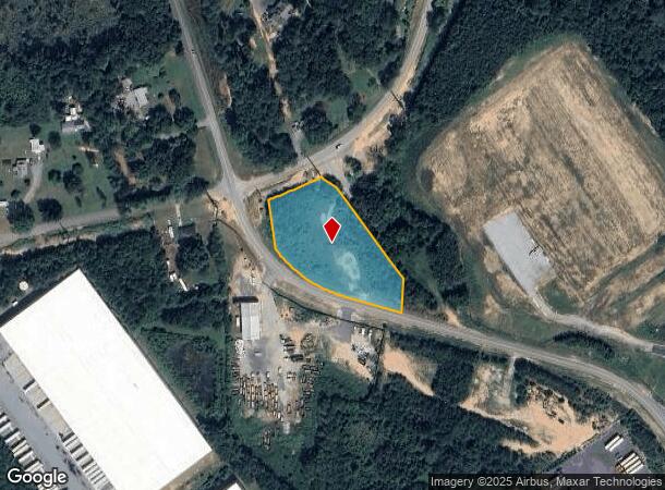
80 Spring Place Rd Nw, Cartersville, GA 30121
NEARBY LISTINGS FOR SALE OR LEASE
Property Detail
80 Spring Place Rd Nw
Atlanta-Sandy Springs-Roswell, GA
Com - Cass White Corridor
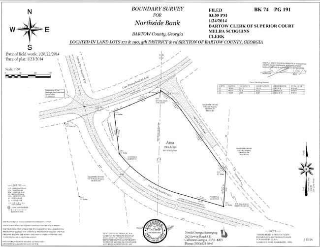
0069-0190-023
LL 170 & 190 LD 5 PLAT 74-191
Industrialacreage
Bartow
X
Georgia
13015C0170H
1.94 AC
2024
Bartow County
2025
Atlanta
960403
DEMOGRAPHICS near 80 Spring Place Rd Nw
1 Mile
3 Mile
5 Mile
2024 Total Population
536
5,445
25,240
2029 Population
572
5,933
27,557
Pop Growth 2024-2029
+ 6.72%
+ 8.96%
+ 9.18%
Average Age
40
40
39
2024 Total Households
195
1,998
9,437
HH Growth 2024-2029
+ 6.15%
+ 8.71%
+ 8.95%
Median Household Inc
$86,627
$85,819
$74,517
Avg Household Size
2.70
2.70
2.60
2024 Avg HH Vehicles
3.00
2.00
2.00
Median Home Value
$285,134
$252,525
$226,163
Median Year Built
1999
1999
1995
Nearby Places
Map Layers
Map Styles
 Street
 Aerial
- Restaurants
- Banks
- Shops
- Fitness
- Groceries
SALE & LEASE HISTORY
LISTING DATE
SALE/LEASE

Sep 24, 2016
For Sale
Sep 10, 2018
For Lease
Mar 26, 2018
For Sale
Mar 07, 2017
For Sale
Jan 30, 2018
For Sale
Nearby Properties
Address
Land Use
TOTAL SIZE
Lot Size
Zoning
Address
Land Use
TOTAL SIZE
Lot Size
Zoning
791,880 SF
77.99 AC
A1
Address
Land Use
TOTAL SIZE
Lot Size
Zoning
144,208 SF
585.38 AC
IN
Address
Land Use
TOTAL SIZE
Lot Size
Zoning
271,357 SF
375.69 AC
IN
Address
Land Use
TOTAL SIZE
Lot Size
Zoning
268,772 SF
168.31 AC
Address
Land Use
TOTAL SIZE
Lot Size
Zoning
1,228,855 SF
193.36 AC
Address
Land Use
TOTAL SIZE
Lot Size
Zoning
823,607 SF
43.60 AC
A1
Address
Land Use
TOTAL SIZE
Lot Size
Zoning
1,107,665 SF
114.40 AC
Address
Land Use
TOTAL SIZE
Lot Size
Zoning
972,763 SF
68.78 AC
Address
Land Use
TOTAL SIZE
Lot Size
Zoning
999,291 SF
73.85 AC
A1
Address
Land Use
TOTAL SIZE
Lot Size
Zoning
311,878 SF
161.30 AC
Address
Land Use
TOTAL SIZE
Lot Size
Zoning
523,059 SF
72.54 AC
Address
Land Use
TOTAL SIZE
Lot Size
Zoning
178,018 SF
48.93 AC
C1
Address
Land Use
TOTAL SIZE
Lot Size
Zoning
646,380 SF
59.66 AC
I1
Address
Land Use
TOTAL SIZE
Lot Size
Zoning
766,373 SF
267.91 AC
I2
Address
Land Use
TOTAL SIZE
Lot Size
Zoning
375,540 SF
31.64 AC
M1
Address
Land Use
TOTAL SIZE
Lot Size
Zoning
526,400 SF
64.52 AC
Address
Land Use
TOTAL SIZE
Lot Size
Zoning
597,183 SF
64.23 AC
Address
Land Use
TOTAL SIZE
Lot Size
Zoning
288,480 SF
40.14 AC
A1
Address
Land Use
TOTAL SIZE
Lot Size
Zoning
273,560 SF
31.38 AC
Address
Land Use
TOTAL SIZE
Lot Size
Zoning
267,558 SF
28.14 AC
A1
Address
Land Use
TOTAL SIZE
Lot Size
Zoning
396,000 SF
60.87 AC
Address
Land Use
TOTAL SIZE
Lot Size
Zoning
337,336 SF
30.59 AC
A1
Address
Land Use
TOTAL SIZE
Lot Size
Zoning
337,615 SF
34.95 AC
A1
Address
Land Use
TOTAL SIZE
Lot Size
Zoning
328,000 SF
43.09 AC
Address
Land Use
TOTAL SIZE
Lot Size
Zoning
207,440 SF
24.78 AC
Address
Land Use
TOTAL SIZE
Lot Size
Zoning
311,476 SF
36.54 AC
Address
Land Use
TOTAL SIZE
Lot Size
Zoning
155,816 SF
39.86 AC
A1
Address
Land Use
TOTAL SIZE
Lot Size
Zoning
265,150 SF
33.26 AC
Address
Land Use
TOTAL SIZE
Lot Size
Zoning
199,800 SF
16.23 AC
A1
Address
Land Use
TOTAL SIZE
Lot Size
Zoning
181.56 AC
A1
The World's #1 Commercial Real Estate Marketplace
Connect with us
© 2026 CoStar Group
The information above has been obtained from sources believed reliable. While we do not doubt its accuracy we have not verified it and make no guarantee, warranty or representation about it. It is your responsibility to independently confirm its accuracy and completeness. Any projections, opinions, assumptions, or estimates used are for example only and do not represent the current or future performance of the property. The value of this transaction to you depends on tax and other factors which should be evaluated by your tax, financial, and legal advisors. You and your advisors should conduct a careful, independent investigation of the property to determine to your satisfaction the suitability of the property for your needs.