Property Record
80 Stanley Ave, Zanesville, OH 43701

NEARBY LISTINGS FOR SALE OR LEASE
-
-
View all Zanesville listings for sale on LoopNet.com
Property Detail
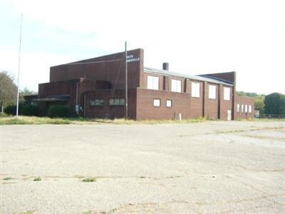
80 Stanley Ave
Commercialnec
R14 TP 15 SEC 1 7.74A
X
Muskingum
39119C0294G
Ohio
0
7.74 AC
2024
Other Market Areas
911800
Zanesville, OH
13,284 SF
62-76-02-08-000
DEMOGRAPHICS near 80 Stanley Ave
1 Mile
3 Mile
5 Mile
2024 Total Population
5,187
23,501
40,304
2029 Population
5,219
23,754
40,590
Pop Growth 2024-2029
+ 0.62%
+ 1.08%
+ 0.71%
Average Age
41
39
40
2024 Total Households
2,212
9,541
16,622
HH Growth 2024-2029
+ 0.59%
+ 1.03%
+ 0.68%
Median Household Inc
$46,122
$36,479
$42,778
Avg Household Size
2.30
2.40
2.30
2024 Avg HH Vehicles
2.00
2.00
2.00
Median Home Value
$87,441
$89,217
$111,792
Median Year Built
1963
1954
1956
Nearby Places
Map Layers
Map Styles
 Street
 Aerial
- Restaurants
- Banks
- Shops
- Fitness
- Groceries
Nearby Properties
Address
Land Use
TOTAL SIZE
Lot Size
Zoning
Address
Land Use
TOTAL SIZE
Lot Size
Zoning
12,480 SF
43.22 AC
Address
Land Use
TOTAL SIZE
Lot Size
Zoning
74,956 SF
10.45 AC
RS5
Address
Land Use
TOTAL SIZE
Lot Size
Zoning
150,499 SF
29.64 AC
Address
Land Use
TOTAL SIZE
Lot Size
Zoning
6,344 SF
19.56 AC
Address
Land Use
TOTAL SIZE
Lot Size
Zoning
184,623 SF
21.08 AC
Address
Land Use
TOTAL SIZE
Lot Size
Zoning
17,723 SF
0.94 AC
C4
Address
Land Use
TOTAL SIZE
Lot Size
Zoning
2,772 SF
4.72 AC
RM1
Address
Land Use
TOTAL SIZE
Lot Size
Zoning
52,564 SF
0.80 AC
C3
Address
Land Use
TOTAL SIZE
Lot Size
Zoning
6,662 SF
13.02 AC
I1
Address
Land Use
TOTAL SIZE
Lot Size
Zoning
56,454 SF
1.50 AC
O2
Address
Land Use
TOTAL SIZE
Lot Size
Zoning
61,732 SF
18.46 AC
Address
Land Use
TOTAL SIZE
Lot Size
Zoning
23,857 SF
0.14 AC
C4
Address
Land Use
TOTAL SIZE
Lot Size
Zoning
51,702 SF
1.69 AC
O2
Address
Land Use
TOTAL SIZE
Lot Size
Zoning
54,300 SF
7.47 AC
Address
Land Use
TOTAL SIZE
Lot Size
Zoning
3.37 AC
I1
Address
Land Use
TOTAL SIZE
Lot Size
Zoning
5,404 SF
15.25 AC
RM1
Address
Land Use
TOTAL SIZE
Lot Size
Zoning
12,720 SF
5.24 AC
Address
Land Use
TOTAL SIZE
Lot Size
Zoning
132,528 SF
2.27 AC
I1
Address
Land Use
TOTAL SIZE
Lot Size
Zoning
98.11 AC
Address
Land Use
TOTAL SIZE
Lot Size
Zoning
51,740 SF
2.76 AC
I1
Address
Land Use
TOTAL SIZE
Lot Size
Zoning
30,836 SF
0.12 AC
C4
Address
Land Use
TOTAL SIZE
Lot Size
Zoning
16,109 SF
3.75 AC
Address
Land Use
TOTAL SIZE
Lot Size
Zoning
40,064 SF
6.55 AC
Address
Land Use
TOTAL SIZE
Lot Size
Zoning
3,400 SF
0.82 AC
C4
Address
Land Use
TOTAL SIZE
Lot Size
Zoning
36,208 SF
0.22 AC
C3
Address
Land Use
TOTAL SIZE
Lot Size
Zoning
96,273 SF
6.41 AC
Address
Land Use
TOTAL SIZE
Lot Size
Zoning
960 SF
20.25 AC
I1
Address
Land Use
TOTAL SIZE
Lot Size
Zoning
38,732 SF
0.11 AC
RS5
Address
Land Use
TOTAL SIZE
Lot Size
Zoning
6,877 SF
12.18 AC
RM1
Address
Land Use
TOTAL SIZE
Lot Size
Zoning
60,453 SF
4.65 AC
RS5
The World's #1 Commercial Real Estate Marketplace
Connect with us
© 2026 CoStar Group
The information above has been obtained from sources believed reliable. While we do not doubt its accuracy we have not verified it and make no guarantee, warranty or representation about it. It is your responsibility to independently confirm its accuracy and completeness. Any projections, opinions, assumptions, or estimates used are for example only and do not represent the current or future performance of the property. The value of this transaction to you depends on tax and other factors which should be evaluated by your tax, financial, and legal advisors. You and your advisors should conduct a careful, independent investigation of the property to determine to your satisfaction the suitability of the property for your needs.