Property Record
80 Stonehill Rd, Oswego, IL 60543

NEARBY LISTINGS FOR SALE OR LEASE
Property Detail
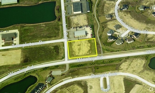
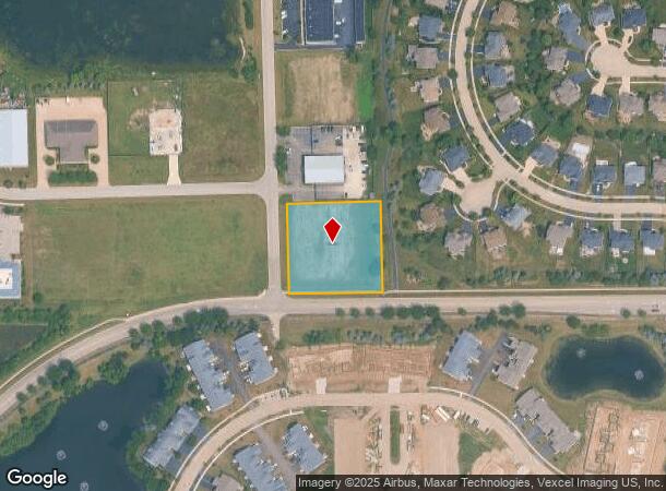
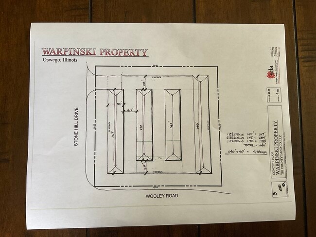
80 Stonehill Rd
Chicago-Naperville-Elgin, IL-IN
Stone Hill Business Park
03-21-102-012
LOT 1 STONE HILL BUSINESS PARK UNIT 2 VILLAGE OF OSWEGO
Industrialgeneral
Kendall
X
Illinois
17093C0065H
1
2024
1.41 AC
2024
Joliet/Central Will
890107
Chicago
DEMOGRAPHICS near 80 Stonehill Rd
1 Mile
3 Mile
5 Mile
2024 Total Population
7,429
40,268
102,549
2029 Population
8,321
44,360
110,952
Pop Growth 2024-2029
+ 12.01%
+ 10.16%
+ 8.19%
Average Age
38
37
37
2024 Total Households
2,381
13,472
33,690
HH Growth 2024-2029
+ 12.18%
+ 10.24%
+ 8.29%
Median Household Inc
$127,214
$93,078
$93,357
Avg Household Size
3.10
2.90
3.00
2024 Avg HH Vehicles
2.00
2.00
2.00
Median Home Value
$333,189
$276,935
$263,722
Median Year Built
2003
1995
1999
Nearby Places
Map Layers
Map Styles
 Street
 Aerial
- Restaurants
- Banks
- Shops
- Fitness
- Groceries
PUBLIC TRANSPORTATION
COMMUTER RAIL
Aurora Station (Burlington Northern-Santa Fe Railway Line - Northeast Illinois Regional Commuter Railroad (Metra))
DRIVE
WALK
Distance
Aurora Station (Burlington Northern-Santa Fe Railway Line - Northeast Illinois Regional Commuter Railroad (Metra))
16 min
8.2 mi
AIRPORT
Chicago Midway International
DRIVE
WALK
Distance
Chicago Midway International
64 min
40.0 mi
Chicago O'Hare International
DRIVE
WALK
Distance
Chicago O'Hare International
81 min
41.5 mi
SALE & LEASE HISTORY
LISTING DATE
SALE/LEASE

Sep 24, 2016
For Sale
Sep 05, 2017
For Lease
Sep 05, 2017
For Sale
May 03, 2022
For Sale
Jun 02, 2023
For Sale
Jan 24, 2019
For Sale
Jan 02, 2019
For Sale
Apr 03, 2018
For Sale
Nearby Properties
Address
Land Use
TOTAL SIZE
Lot Size
Zoning
Address
Land Use
TOTAL SIZE
Lot Size
Zoning
121,608 SF
27.48 AC
Address
Land Use
TOTAL SIZE
Lot Size
Zoning
296,502 SF
19.01 AC
Address
Land Use
TOTAL SIZE
Lot Size
Zoning
20.76 AC
Address
Land Use
TOTAL SIZE
Lot Size
Zoning
9.86 AC
Address
Land Use
TOTAL SIZE
Lot Size
Zoning
220,091 SF
22.09 AC
Address
Land Use
TOTAL SIZE
Lot Size
Zoning
156,614 SF
17.63 AC
Address
Land Use
TOTAL SIZE
Lot Size
Zoning
207,596 SF
20.63 AC
Address
Land Use
TOTAL SIZE
Lot Size
Zoning
122,387 SF
21.92 AC
Address
Land Use
TOTAL SIZE
Lot Size
Zoning
118,236 SF
20.93 AC
Address
Land Use
TOTAL SIZE
Lot Size
Zoning
140,888 SF
16.31 AC
Address
Land Use
TOTAL SIZE
Lot Size
Zoning
87,746 SF
8.01 AC
Address
Land Use
TOTAL SIZE
Lot Size
Zoning
49,292 SF
1.70 AC
Address
Land Use
TOTAL SIZE
Lot Size
Zoning
49,292 SF
1.70 AC
Address
Land Use
TOTAL SIZE
Lot Size
Zoning
49,292 SF
1.70 AC
Address
Land Use
TOTAL SIZE
Lot Size
Zoning
125,513 SF
9.94 AC
Address
Land Use
TOTAL SIZE
Lot Size
Zoning
120,750 SF
11.07 AC
Address
Land Use
TOTAL SIZE
Lot Size
Zoning
62,164 SF
6.76 AC
Address
Land Use
TOTAL SIZE
Lot Size
Zoning
39,020 SF
1.70 AC
Address
Land Use
TOTAL SIZE
Lot Size
Zoning
31.35 AC
Address
Land Use
TOTAL SIZE
Lot Size
Zoning
65,040 SF
6.04 AC
Address
Land Use
TOTAL SIZE
Lot Size
Zoning
65,982 SF
5.21 AC
Address
Land Use
TOTAL SIZE
Lot Size
Zoning
33,730 SF
6.95 AC
Address
Land Use
TOTAL SIZE
Lot Size
Zoning
120,058 SF
10.71 AC
Address
Land Use
TOTAL SIZE
Lot Size
Zoning
18,774 SF
4.95 AC
Address
Land Use
TOTAL SIZE
Lot Size
Zoning
36,711 SF
0.44 AC
Address
Land Use
TOTAL SIZE
Lot Size
Zoning
88,798 SF
7.91 AC
Address
Land Use
TOTAL SIZE
Lot Size
Zoning
16,152 SF
2.40 AC
Address
Land Use
TOTAL SIZE
Lot Size
Zoning
26,220 SF
3.52 AC
Address
Land Use
TOTAL SIZE
Lot Size
Zoning
65,646 SF
2.76 AC
Address
Land Use
TOTAL SIZE
Lot Size
Zoning
8,056 SF
2.64 AC
The World's #1 Commercial Real Estate Marketplace
Connect with us
© 2026 CoStar Group
The information above has been obtained from sources believed reliable. While we do not doubt its accuracy we have not verified it and make no guarantee, warranty or representation about it. It is your responsibility to independently confirm its accuracy and completeness. Any projections, opinions, assumptions, or estimates used are for example only and do not represent the current or future performance of the property. The value of this transaction to you depends on tax and other factors which should be evaluated by your tax, financial, and legal advisors. You and your advisors should conduct a careful, independent investigation of the property to determine to your satisfaction the suitability of the property for your needs.