Property Record
80 W 64Th St, Holland, MI 49423
NEARBY LISTINGS FOR SALE OR LEASE
Property Detail
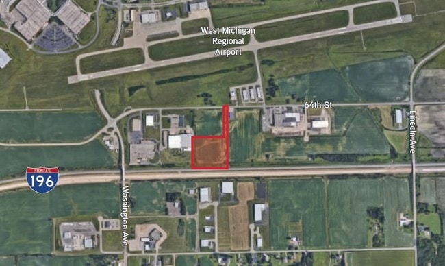
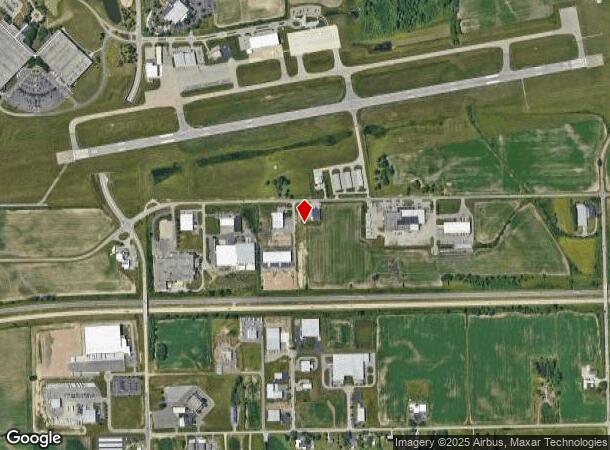
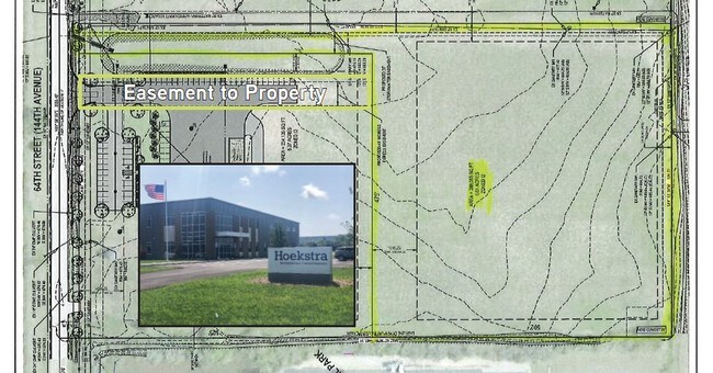
80 W 64Th St
Holland, MI
Runway View Industrial Park Condominium
53-02-17-100-029
COM N 1/4 COR SEC 17 TH S 89D 56M 05S W ALG N LI NW 1/4 SDSEC 801.15 FT TO POB TH S 00D 00M 14S W 1026.77 FT TO NLY R OW LI I-196 TH S 89D 53M 39S WA LG SDNLY LI 524.20 FT TO E LI AIRPORT INDUSTRIAL PARK TH N 00D 07M 36S W ALG SD E LI 102 7.14 FT TO
Manufacturinglight
Allegan
2021
Michigan
2021
11.99 AC
0324011082
NE Allegan/Holland
21,600 SF
West Michigan
DEMOGRAPHICS near 80 W 64Th St
1 Mile
3 Mile
5 Mile
2024 Total Population
155
20,666
54,959
2029 Population
158
21,269
57,181
Pop Growth 2024-2029
+ 1.94%
+ 2.92%
+ 4.04%
Average Age
42
40
40
2024 Total Households
59
8,069
20,800
HH Growth 2024-2029
+ 1.69%
+ 2.85%
+ 4.14%
Median Household Inc
$72,954
$67,017
$71,930
Avg Household Size
2.50
2.50
2.50
2024 Avg HH Vehicles
2.00
2.00
2.00
Median Home Value
$258,333
$211,358
$242,765
Median Year Built
1977
1970
1973
Nearby Places
Map Layers
Map Styles
 Street
 Aerial
- Restaurants
- Banks
- Shops
- Fitness
- Groceries
PUBLIC TRANSPORTATION
COMMUTER RAIL
Holland Amtrak Station (Pere Marquette - Amtrak)
DRIVE
WALK
Distance
Holland Amtrak Station (Pere Marquette - Amtrak)
11 min
4.8 mi
Freight Ports
Port Milwaukee
DRIVE
WALK
Distance
Port Milwaukee
276 min
233.3 mi
SALE & LEASE HISTORY
LISTING DATE
SALE/LEASE

Jul 22, 2019
For Sale
Nearby Properties
Address
Land Use
TOTAL SIZE
Lot Size
Zoning
Address
Land Use
TOTAL SIZE
Lot Size
Zoning
1,599,294 SF
Address
Land Use
TOTAL SIZE
Lot Size
Zoning
1,788,352 SF
173.33 AC
Address
Land Use
TOTAL SIZE
Lot Size
Zoning
682,378 SF
99.60 AC
NA
Address
Land Use
TOTAL SIZE
Lot Size
Zoning
198,712 SF
Address
Land Use
TOTAL SIZE
Lot Size
Zoning
630,943 SF
28.50 AC
Address
Land Use
TOTAL SIZE
Lot Size
Zoning
556,819 SF
85.45 AC
Address
Land Use
TOTAL SIZE
Lot Size
Zoning
674,052 SF
79.30 AC
Address
Land Use
TOTAL SIZE
Lot Size
Zoning
154,107 SF
Address
Land Use
TOTAL SIZE
Lot Size
Zoning
239,465 SF
Address
Land Use
TOTAL SIZE
Lot Size
Zoning
118,444 SF
4.39 AC
Address
Land Use
TOTAL SIZE
Lot Size
Zoning
589,649 SF
92.65 AC
Address
Land Use
TOTAL SIZE
Lot Size
Zoning
150,822 SF
Address
Land Use
TOTAL SIZE
Lot Size
Zoning
114,088 SF
10.79 AC
PRD
Address
Land Use
TOTAL SIZE
Lot Size
Zoning
181,754 SF
13.44 AC
R3
Address
Land Use
TOTAL SIZE
Lot Size
Zoning
391,842 SF
28.34 AC
Address
Land Use
TOTAL SIZE
Lot Size
Zoning
372,017 SF
17.60 AC
R-2
Address
Land Use
TOTAL SIZE
Lot Size
Zoning
357,000 SF
23.35 AC
Address
Land Use
TOTAL SIZE
Lot Size
Zoning
73,700 SF
Address
Land Use
TOTAL SIZE
Lot Size
Zoning
397,258 SF
36.66 AC
I2
Address
Land Use
TOTAL SIZE
Lot Size
Zoning
158,661 SF
17.28 AC
Address
Land Use
TOTAL SIZE
Lot Size
Zoning
146,357 SF
20.04 AC
Address
Land Use
TOTAL SIZE
Lot Size
Zoning
73,663 SF
4.66 AC
Address
Land Use
TOTAL SIZE
Lot Size
Zoning
252,065 SF
13.98 AC
Address
Land Use
TOTAL SIZE
Lot Size
Zoning
404,600 SF
23.23 AC
I2
Address
Land Use
TOTAL SIZE
Lot Size
Zoning
132,108 SF
9.97 AC
I-1
Address
Land Use
TOTAL SIZE
Lot Size
Zoning
281,775 SF
Address
Land Use
TOTAL SIZE
Lot Size
Zoning
124,176 SF
7.88 AC
I
Address
Land Use
TOTAL SIZE
Lot Size
Zoning
55,088 SF
Address
Land Use
TOTAL SIZE
Lot Size
Zoning
300,000 SF
Address
Land Use
TOTAL SIZE
Lot Size
Zoning
140,700 SF
20.28 AC
The World's #1 Commercial Real Estate Marketplace
Connect with us
© 2025 CoStar Group
The information above has been obtained from sources believed reliable. While we do not doubt its accuracy we have not verified it and make no guarantee, warranty or representation about it. It is your responsibility to independently confirm its accuracy and completeness. Any projections, opinions, assumptions, or estimates used are for example only and do not represent the current or future performance of the property. The value of this transaction to you depends on tax and other factors which should be evaluated by your tax, financial, and legal advisors. You and your advisors should conduct a careful, independent investigation of the property to determine to your satisfaction the suitability of the property for your needs.