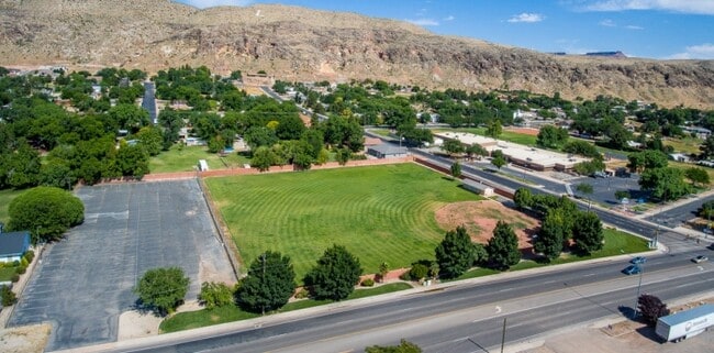
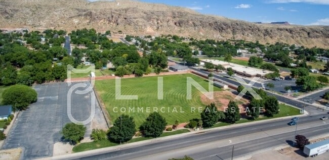
Property Record
80 W Center St, La Verkin, UT 84745

Property Detail
80 W Center St
St. George, UT
SUBDIVISION: LA VERKIN FIELD SUR LOT 36 (LV) BEG SW COR LOT 36 LVFS TH N01*1414 E ALG W LN LOT 36 520.85 FT TO SW COR TENTMAKERS BIBLE MISSION PROP; TH N89*46 E ALG SLY LN SD PRPTY 321.30 FT TO PT ON E LN LOT 36; TH S0*1515 E 520.68 FT TO PT ON S LN
0087828
WASHINGTON
Commercialnec
Utah
B and X Area of moderate flood hazard, usually the area between the limits of the 100-year and 500-year floods.
36
2024
3.78 AC
2025
Cedar City & St George
271000
Other Market Areas
432 SF
NEARBY LISTINGS FOR SALE OR LEASE
DEMOGRAPHICS near 80 W Center St
1 mile
3 mile
5 mile
2025 Total Population
4,545
13,789
21,547
2030 Population
4,924
14,911
23,401
Pop Growth 2025-2030
+ 8.34%
+ 8.14%
+ 8.60%
Average Age
38
38
40
2025 Total Households
1,458
4,339
7,221
HH Growth 2025-2030
+ 8.64%
+ 8.41%
+ 8.95%
Median Household Inc
$62,482
$72,538
$74,561
Avg Household Size
3.10
3.10
2.90
2025 Avg HH Vehicles
2.00
2.00
2.00
Median Home Value
$423,591
$452,126
$475,412
Median Year Built
1996
1995
2001
Nearby Places
Map Layers
Map Styles
 Street
 Aerial
Layers
 Traffic
 Biking
Places
Listings with unknown addresses are not visible on the map
- Restaurants
- Banks
- Shops
- Fitness
- Groceries
PUBLIC TRANSPORTATION
AIRPORT
St George Regional
Drive
Walk
Distance
St George Regional
37 min
22.5 mi
SALE & LEASE HISTORY
LISTING DATE
SALE/LEASE

Jun 16, 2020
For Sale
Nearby Properties
Address
Land Use
TOTAL SIZE
Lot Size
Zoning
Address
Land Use
TOTAL SIZE
Lot Size
Zoning
93,494 SF
23.97 AC
PF
Address
Land Use
TOTAL SIZE
Lot Size
Zoning
70,194 SF
2.79 AC
Address
Land Use
TOTAL SIZE
Lot Size
Zoning
55,676 SF
8.90 AC
PF
Address
Land Use
TOTAL SIZE
Lot Size
Zoning
50,591 SF
2.27 AC
Address
Land Use
TOTAL SIZE
Lot Size
Zoning
48,863 SF
1.72 AC
HC
Address
Land Use
TOTAL SIZE
Lot Size
Zoning
13,516 SF
11.45 AC
Address
Land Use
TOTAL SIZE
Lot Size
Zoning
40,650 SF
2.99 AC
Address
Land Use
TOTAL SIZE
Lot Size
Zoning
30,643 SF
26.13 AC
PDO
Address
Land Use
TOTAL SIZE
Lot Size
Zoning
33,657 SF
12.90 AC
Address
Land Use
TOTAL SIZE
Lot Size
Zoning
134,714 SF
14.80 AC
M-1
Address
Land Use
TOTAL SIZE
Lot Size
Zoning
42,267 SF
3.09 AC
HC
Address
Land Use
TOTAL SIZE
Lot Size
Zoning
22,080 SF
6.82 AC
HC
Address
Land Use
TOTAL SIZE
Lot Size
Zoning
30,519 SF
5.76 AC
HC
Address
Land Use
TOTAL SIZE
Lot Size
Zoning
22,576 SF
5.35 AC
Address
Land Use
TOTAL SIZE
Lot Size
Zoning
48,990 SF
24.69 AC
PF
Address
Land Use
TOTAL SIZE
Lot Size
Zoning
34,486 SF
3.03 AC
HC
Address
Land Use
TOTAL SIZE
Lot Size
Zoning
41,124 SF
4.83 AC
Address
Land Use
TOTAL SIZE
Lot Size
Zoning
14,739 SF
1.48 AC
HC
Address
Land Use
TOTAL SIZE
Lot Size
Zoning
25,105 SF
2.97 AC
Address
Land Use
TOTAL SIZE
Lot Size
Zoning
22,435 SF
0.74 AC
HC
Address
Land Use
TOTAL SIZE
Lot Size
Zoning
10,930 SF
4.22 AC
HC
Address
Land Use
TOTAL SIZE
Lot Size
Zoning
10,394 SF
1.81 AC
HC
Address
Land Use
TOTAL SIZE
Lot Size
Zoning
87,486 SF
3.06 AC
Address
Land Use
TOTAL SIZE
Lot Size
Zoning
10,491 SF
10.93 AC
Address
Land Use
TOTAL SIZE
Lot Size
Zoning
6,550 SF
60 AC
OSC20
Address
Land Use
TOTAL SIZE
Lot Size
Zoning
7,937 SF
1.64 AC
HC
Address
Land Use
TOTAL SIZE
Lot Size
Zoning
7,326 SF
1.39 AC
Address
Land Use
TOTAL SIZE
Lot Size
Zoning
11,994 SF
15.02 AC
Address
Land Use
TOTAL SIZE
Lot Size
Zoning
19,050 SF
2.53 AC
M-1
The World's #1 Commercial Real Estate Marketplace
Connect with us
© 2026 CoStar Group
The information above has been obtained from sources believed reliable. While we do not doubt its accuracy we have not verified it and make no guarantee, warranty or representation about it. It is your responsibility to independently confirm its accuracy and completeness. Any projections, opinions, assumptions, or estimates used are for example only and do not represent the current or future performance of the property. The value of this transaction to you depends on tax and other factors which should be evaluated by your tax, financial, and legal advisors. You and your advisors should conduct a careful, independent investigation of the property to determine to your satisfaction the suitability of the property for your needs.