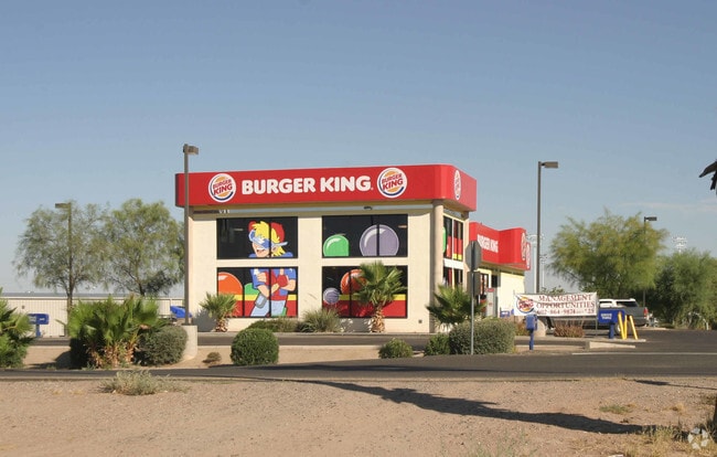
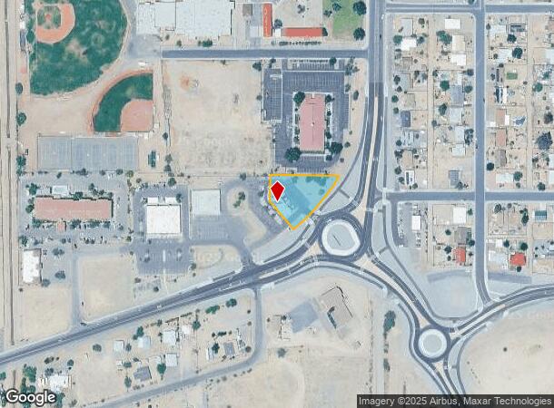
Property Record
80 W Highway 287, Florence, AZ 85132


NEARBY LISTINGS FOR SALE OR LEASE
Property Detail
80 W Highway 287
202-06-001F
BEG AT SE COR OF SAID SEC 2-5S-9E TH N-1318 W-156' TO POB W-279' TH S-94' TH S-40 DEG E-151.82' TO N R/W LINE OF AZ ST RT 287 TH N ELY TO POB SEC 2-5S-9E .82 AC
Restaurantdrivein
Pinal
X
Arizona
04021C0870E
0.82 AC
2024
Outlying Pinal County
2025
Phoenix
000804
Phoenix-Mesa-Scottsdale, AZ
2,880 SF
DEMOGRAPHICS near 80 W Highway 287
1 Mile
3 Mile
5 Mile
2024 Total Population
2,558
5,705
13,542
2029 Population
3,135
6,445
16,168
Pop Growth 2024-2029
+ 22.56%
+ 12.97%
+ 19.39%
Average Age
38
41
47
2024 Total Households
960
1,184
4,066
HH Growth 2024-2029
+ 21.88%
+ 22.04%
+ 28.70%
Median Household Inc
$60,465
$60,463
$48,295
Avg Household Size
2.60
2.60
2.10
2024 Avg HH Vehicles
2.00
2.00
2.00
Median Home Value
$183,333
$180,701
$140,093
Median Year Built
1979
1983
1993
Nearby Places
Map Layers
Map Styles
 Street
 Aerial
- Restaurants
- Banks
- Shops
- Fitness
- Groceries
PUBLIC TRANSPORTATION
AIRPORT
Phoenix-Mesa Gateway
DRIVE
WALK
Distance
Phoenix-Mesa Gateway
52 min
31.6 mi
Nearby Properties
Address
Land Use
TOTAL SIZE
Lot Size
Zoning
Address
Land Use
TOTAL SIZE
Lot Size
Zoning
583,508 SF
32.12 AC
UNDESIGNAT
Address
Land Use
TOTAL SIZE
Lot Size
Zoning
388,169 SF
33.33 AC
UNDESIGNAT
Address
Land Use
TOTAL SIZE
Lot Size
Zoning
199,261 SF
19.06 AC
UNDESIGNAT
Address
Land Use
TOTAL SIZE
Lot Size
Zoning
128,660 SF
4.80 AC
UNDESIGNAT
Address
Land Use
TOTAL SIZE
Lot Size
Zoning
303,040 SF
12.34 AC
Address
Land Use
TOTAL SIZE
Lot Size
Zoning
11.58 AC
Address
Land Use
TOTAL SIZE
Lot Size
Zoning
102,629 SF
17.85 AC
UNDESIGNAT
Address
Land Use
TOTAL SIZE
Lot Size
Zoning
51,000 SF
5.71 AC
Address
Land Use
TOTAL SIZE
Lot Size
Zoning
71,889 SF
10.43 AC
Address
Land Use
TOTAL SIZE
Lot Size
Zoning
27,177 SF
125.23 AC
Address
Land Use
TOTAL SIZE
Lot Size
Zoning
89,998 SF
7.92 AC
Address
Land Use
TOTAL SIZE
Lot Size
Zoning
38,044 SF
1.62 AC
UNDESIGNAT
Address
Land Use
TOTAL SIZE
Lot Size
Zoning
19.98 AC
UNDESIGNAT
Address
Land Use
TOTAL SIZE
Lot Size
Zoning
Address
Land Use
TOTAL SIZE
Lot Size
Zoning
56,028 SF
2.44 AC
UNDESIGNAT
Address
Land Use
TOTAL SIZE
Lot Size
Zoning
32.30 AC
Address
Land Use
TOTAL SIZE
Lot Size
Zoning
39,036 SF
4.88 AC
UNDESIGNAT
Address
Land Use
TOTAL SIZE
Lot Size
Zoning
14,990 SF
6.44 AC
UNDESIGNAT
Address
Land Use
TOTAL SIZE
Lot Size
Zoning
12,100 SF
2.40 AC
Address
Land Use
TOTAL SIZE
Lot Size
Zoning
11,100 SF
3.10 AC
UNDESIGNAT
Address
Land Use
TOTAL SIZE
Lot Size
Zoning
Address
Land Use
TOTAL SIZE
Lot Size
Zoning
11.97 AC
UNDESIGNAT
Address
Land Use
TOTAL SIZE
Lot Size
Zoning
17,914 SF
2.23 AC
UNDESIGNAT
Address
Land Use
TOTAL SIZE
Lot Size
Zoning
7,636 SF
3.56 AC
Address
Land Use
TOTAL SIZE
Lot Size
Zoning
210.16 AC
UNDESIGNAT
Address
Land Use
TOTAL SIZE
Lot Size
Zoning
784 SF
3.84 AC
Address
Land Use
TOTAL SIZE
Lot Size
Zoning
8,564 SF
1.53 AC
Address
Land Use
TOTAL SIZE
Lot Size
Zoning
5,305 SF
0.66 AC
UNDESIGNAT
Address
Land Use
TOTAL SIZE
Lot Size
Zoning
5,308 SF
1.51 AC
The World's #1 Commercial Real Estate Marketplace
Connect with us
© 2025 CoStar Group
The information above has been obtained from sources believed reliable. While we do not doubt its accuracy we have not verified it and make no guarantee, warranty or representation about it. It is your responsibility to independently confirm its accuracy and completeness. Any projections, opinions, assumptions, or estimates used are for example only and do not represent the current or future performance of the property. The value of this transaction to you depends on tax and other factors which should be evaluated by your tax, financial, and legal advisors. You and your advisors should conduct a careful, independent investigation of the property to determine to your satisfaction the suitability of the property for your needs.