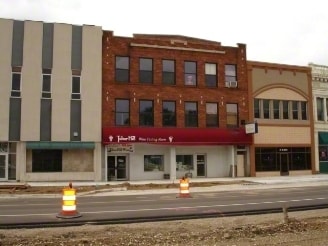
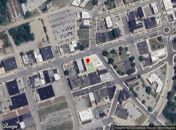
Property Record
80 W Main St, Benton Harbor, MI 49022
NEARBY LISTINGS FOR SALE OR LEASE
Property Detail
80 W Main St
Niles-Benton Harbor, MI
Original Plat Of The City Of Benton Harb
11-51-0340-0206-03-0
SPLIT/COMBINED ON 05/23/2019 FROM 51-0340-0206-02-1, 51-0340-0205-03-2, 51-0340-0206-01-2; COM 61.8' S72DEG10'W OF NE COR LOT 1 BLOCK 23 ORIGINAL PLAT OF THE VILL OF BRUNSON HARBOR NOW CITYTH S17DEG59'E 125' (REC 126') TH S72DEG10'W 45.79' TH N17DEG3
Commercialnec
Berrien
X
Michigan
26021C0102D
1
0
0.13 AC
2025
Michigan Southwest Area
000400
Other Market Areas
23,030 SF
DEMOGRAPHICS near 80 W Main St
1 Mile
3 Mile
5 Mile
2024 Total Population
6,235
30,623
42,454
2029 Population
6,331
30,350
41,880
Pop Growth 2024-2029
+ 1.54%
(0.89%)
(1.35%)
Average Age
35
39
40
2024 Total Households
2,293
12,774
17,749
HH Growth 2024-2029
+ 1.22%
(1.28%)
(1.68%)
Median Household Inc
$27,675
$35,984
$45,815
Avg Household Size
2.50
2.30
2.30
2024 Avg HH Vehicles
1.00
1.00
2.00
Median Home Value
$83,816
$161,920
$187,133
Median Year Built
1962
1958
1961
Nearby Places
Map Layers
Map Styles
 Street
 Aerial
- Restaurants
- Banks
- Shops
- Fitness
- Groceries
PUBLIC TRANSPORTATION
COMMUTER RAIL
DRIVE
WALK
Distance
5 min
1.9 mi
AIRPORT
South Bend International
DRIVE
WALK
Distance
South Bend International
51 min
37.1 mi
SALE & LEASE HISTORY
LISTING DATE
SALE/LEASE

Sep 25, 2016
For Lease
Sep 23, 2016
For Sale
Nearby Properties
Address
Land Use
TOTAL SIZE
Lot Size
Zoning
Address
Land Use
TOTAL SIZE
Lot Size
Zoning
313,588 SF
11.48 AC
DISTRICT A
Address
Land Use
TOTAL SIZE
Lot Size
Zoning
365,903 SF
95.25 AC
Address
Land Use
TOTAL SIZE
Lot Size
Zoning
216,232 SF
Address
Land Use
TOTAL SIZE
Lot Size
Zoning
89,062 SF
1.60 AC
W
Address
Land Use
TOTAL SIZE
Lot Size
Zoning
99,468 SF
10.07 AC
DISTRICT G
Address
Land Use
TOTAL SIZE
Lot Size
Zoning
218,334 SF
25.05 AC
Address
Land Use
TOTAL SIZE
Lot Size
Zoning
202,713 SF
14.23 AC
CO-A
Address
Land Use
TOTAL SIZE
Lot Size
Zoning
296,788 SF
34 AC
D1 COMM
Address
Land Use
TOTAL SIZE
Lot Size
Zoning
30,889 SF
2.83 AC
CO-A
Address
Land Use
TOTAL SIZE
Lot Size
Zoning
258,549 SF
17.20 AC
C MULTI
Address
Land Use
TOTAL SIZE
Lot Size
Zoning
62,800 SF
3.06 AC
Address
Land Use
TOTAL SIZE
Lot Size
Zoning
69,750 SF
0.47 AC
D
Address
Land Use
TOTAL SIZE
Lot Size
Zoning
171,165 SF
15.15 AC
D1 COMM
Address
Land Use
TOTAL SIZE
Lot Size
Zoning
112,503 SF
4.30 AC
C MULTI FA
Address
Land Use
TOTAL SIZE
Lot Size
Zoning
86,000 SF
22.38 AC
D1 COMM
Address
Land Use
TOTAL SIZE
Lot Size
Zoning
93,032 SF
0.51 AC
D
Address
Land Use
TOTAL SIZE
Lot Size
Zoning
75,050 SF
5.33 AC
NONE
Address
Land Use
TOTAL SIZE
Lot Size
Zoning
126,127 SF
11.84 AC
D1 COMM
Address
Land Use
TOTAL SIZE
Lot Size
Zoning
108,300 SF
12.36 AC
DISTRICT F
Address
Land Use
TOTAL SIZE
Lot Size
Zoning
82,567 SF
1.74 AC
D
Address
Land Use
TOTAL SIZE
Lot Size
Zoning
90,000 SF
7.62 AC
W
Address
Land Use
TOTAL SIZE
Lot Size
Zoning
65,584 SF
6.52 AC
CO-A
Address
Land Use
TOTAL SIZE
Lot Size
Zoning
84,732 SF
4.19 AC
C MULTI FA
Address
Land Use
TOTAL SIZE
Lot Size
Zoning
40,063 SF
9.78 AC
DISTRICT G
Address
Land Use
TOTAL SIZE
Lot Size
Zoning
25,080 SF
I-1
Address
Land Use
TOTAL SIZE
Lot Size
Zoning
70,617 SF
12 AC
E RESTRICT
Address
Land Use
TOTAL SIZE
Lot Size
Zoning
103,591 SF
8.77 AC
D1 COMM
Address
Land Use
TOTAL SIZE
Lot Size
Zoning
69,484 SF
8.08 AC
C MULTI
Address
Land Use
TOTAL SIZE
Lot Size
Zoning
18.05 AC
D1 COMM
Address
Land Use
TOTAL SIZE
Lot Size
Zoning
151,462 SF
9.96 AC
DISTRICT F
The World's #1 Commercial Real Estate Marketplace
Connect with us
© 2026 CoStar Group
The information above has been obtained from sources believed reliable. While we do not doubt its accuracy we have not verified it and make no guarantee, warranty or representation about it. It is your responsibility to independently confirm its accuracy and completeness. Any projections, opinions, assumptions, or estimates used are for example only and do not represent the current or future performance of the property. The value of this transaction to you depends on tax and other factors which should be evaluated by your tax, financial, and legal advisors. You and your advisors should conduct a careful, independent investigation of the property to determine to your satisfaction the suitability of the property for your needs.