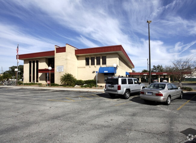
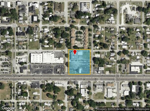
Property Record
800 13Th St, Saint Cloud, FL 34769

NEARBY LISTINGS FOR SALE OR LEASE
Property Detail
800 13Th St
Orlando-Kissimmee-Sanford, FL
St Cloud 2Nd Plat Town Of
01-26-30-0001-0224-0010
ST CLOUD PB B PG 34 BLK 224 LOTS 1-24 & ALL VAC 12TH ST N OF BLK 224 ORD# 72-I 1128/1378 2/26/30
Countyproperty
Osceola
X
Florida
12097C0257G
1
0
2.39 AC
2025
St Cloud
043500
Orlando
14,953 SF
DEMOGRAPHICS near 800 13Th St
1 Mile
3 Mile
5 Mile
2024 Total Population
10,080
50,328
94,497
2029 Population
12,018
60,402
113,804
Pop Growth 2024-2029
+ 19.23%
+ 20.02%
+ 20.43%
Average Age
39
39
38
2024 Total Households
3,875
17,748
31,897
HH Growth 2024-2029
+ 19.02%
+ 19.81%
+ 20.35%
Median Household Inc
$59,184
$63,684
$67,019
Avg Household Size
2.60
2.80
2.90
2024 Avg HH Vehicles
2.00
2.00
2.00
Median Home Value
$242,530
$287,312
$305,259
Median Year Built
1979
1999
2004
Nearby Places
Map Layers
Map Styles
 Street
 Aerial
- Restaurants
- Banks
- Shops
- Fitness
- Groceries
PUBLIC TRANSPORTATION
COMMUTER RAIL
DRIVE
WALK
Distance
17 min
8.9 mi
AIRPORT
Orlando International
DRIVE
WALK
Distance
Orlando International
31 min
18.6 mi
Freight Ports
Port Canaveral
DRIVE
WALK
Distance
Port Canaveral
74 min
56.5 mi
Nearby Properties
Address
Land Use
TOTAL SIZE
Lot Size
Zoning
Address
Land Use
TOTAL SIZE
Lot Size
Zoning
270,959 SF
10.84 AC
SPUD
Address
Land Use
TOTAL SIZE
Lot Size
Zoning
275,507 SF
22.19 AC
RM-2
Address
Land Use
TOTAL SIZE
Lot Size
Zoning
313,120 SF
54.86 AC
SP
Address
Land Use
TOTAL SIZE
Lot Size
Zoning
118,121 SF
237.16 AC
SP
Address
Land Use
TOTAL SIZE
Lot Size
Zoning
208,677 SF
12.64 AC
Address
Land Use
TOTAL SIZE
Lot Size
Zoning
198,144 SF
12.18 AC
SR4
Address
Land Use
TOTAL SIZE
Lot Size
Zoning
185,953 SF
63.41 AC
SP
Address
Land Use
TOTAL SIZE
Lot Size
Zoning
227,369 SF
18.57 AC
ORM3
Address
Land Use
TOTAL SIZE
Lot Size
Zoning
82,614 SF
9.89 AC
SHB
Address
Land Use
TOTAL SIZE
Lot Size
Zoning
188,778 SF
15.62 AC
SR4
Address
Land Use
TOTAL SIZE
Lot Size
Zoning
77,928 SF
24.79 AC
SHB
Address
Land Use
TOTAL SIZE
Lot Size
Zoning
127,960 SF
14.40 AC
SPUD
Address
Land Use
TOTAL SIZE
Lot Size
Zoning
106,078 SF
15.04 AC
SP
Address
Land Use
TOTAL SIZE
Lot Size
Zoning
50,025 SF
4.45 AC
SP
Address
Land Use
TOTAL SIZE
Lot Size
Zoning
79,854 SF
8.89 AC
SHB
Address
Land Use
TOTAL SIZE
Lot Size
Zoning
136,124 SF
14.46 AC
SAC
Address
Land Use
TOTAL SIZE
Lot Size
Zoning
122,514 SF
22.15 AC
OAC
Address
Land Use
TOTAL SIZE
Lot Size
Zoning
55,521 SF
10.75 AC
SHB
Address
Land Use
TOTAL SIZE
Lot Size
Zoning
187,534 SF
19.79 AC
Address
Land Use
TOTAL SIZE
Lot Size
Zoning
60,772 SF
6.42 AC
SP
Address
Land Use
TOTAL SIZE
Lot Size
Zoning
84,902 SF
11.12 AC
SPUD
Address
Land Use
TOTAL SIZE
Lot Size
Zoning
66,682 SF
8.42 AC
SHB
Address
Land Use
TOTAL SIZE
Lot Size
Zoning
88,725 SF
5.79 AC
SHB
Address
Land Use
TOTAL SIZE
Lot Size
Zoning
89,482 SF
4.82 AC
SPUD
Address
Land Use
TOTAL SIZE
Lot Size
Zoning
78,510 SF
3.95 AC
SI1
Address
Land Use
TOTAL SIZE
Lot Size
Zoning
30,520 SF
5.94 AC
SHB
Address
Land Use
TOTAL SIZE
Lot Size
Zoning
103,716 SF
16.73 AC
SHB
Address
Land Use
TOTAL SIZE
Lot Size
Zoning
88,369 SF
15.54 AC
Address
Land Use
TOTAL SIZE
Lot Size
Zoning
92,108 SF
11.44 AC
SHB
Address
Land Use
TOTAL SIZE
Lot Size
Zoning
17.38 AC
AC
The World's #1 Commercial Real Estate Marketplace
Connect with us
© 2026 CoStar Group
The information above has been obtained from sources believed reliable. While we do not doubt its accuracy we have not verified it and make no guarantee, warranty or representation about it. It is your responsibility to independently confirm its accuracy and completeness. Any projections, opinions, assumptions, or estimates used are for example only and do not represent the current or future performance of the property. The value of this transaction to you depends on tax and other factors which should be evaluated by your tax, financial, and legal advisors. You and your advisors should conduct a careful, independent investigation of the property to determine to your satisfaction the suitability of the property for your needs.