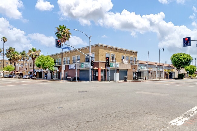
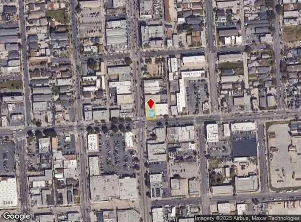
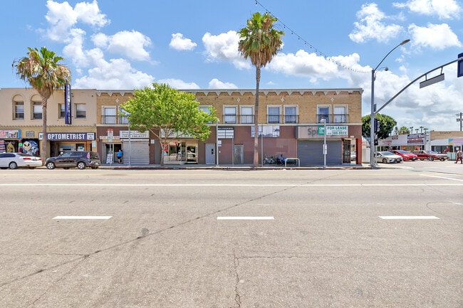
Property Record
800 N Avalon Blvd, Wilmington, CA 90744

Current Lease Availabilities
NEARBY LISTINGS FOR SALE OR LEASE
Property Detail
800 N Avalon Blvd
Los Angeles-Long Beach-Glendale, CA
Canal Street Tract
7423-003-021
CANAL ST TRACT W 50 FT OF LOTS 7 AND LOT 8 BLK F
Storesoffices
Los Angeles
X
California
06037C1944G
7,8
2024
0.12 AC
2025
Beach Cities/Palos Verdes
294610
Los Angeles
8,952 SF
DEMOGRAPHICS near 800 N Avalon Blvd
1 Mile
3 Mile
5 Mile
2024 Total Population
36,113
127,370
460,920
2029 Population
34,874
122,962
447,025
Pop Growth 2024-2029
(3.43%)
(3.46%)
(3.01%)
Average Age
35
39
40
2024 Total Households
9,829
38,206
155,884
HH Growth 2024-2029
(3.68%)
(3.63%)
(3.08%)
Median Household Inc
$50,203
$70,376
$72,951
Avg Household Size
3.50
3.10
2.80
2024 Avg HH Vehicles
2.00
2.00
2.00
Median Home Value
$586,758
$655,598
$708,174
Median Year Built
1960
1966
1964
Nearby Places
Map Layers
Map Styles
 Street
 Aerial
- Restaurants
- Banks
- Shops
- Fitness
- Groceries
PUBLIC TRANSPORTATION
AIRPORT
Long Beach (Daugherty Field)
DRIVE
WALK
Distance
Long Beach (Daugherty Field)
15 min
8.9 mi
Los Angeles International
DRIVE
WALK
Distance
Los Angeles International
26 min
18.4 mi
John Wayne/Orange County
DRIVE
WALK
Distance
John Wayne/Orange County
38 min
29.1 mi
Freight Ports
Port of Los Angeles
DRIVE
WALK
Distance
Port of Los Angeles
13 min
5.2 mi
Nearby Properties
Address
Land Use
TOTAL SIZE
Lot Size
Zoning
Address
Land Use
TOTAL SIZE
Lot Size
Zoning
671,091 SF
18 AC
LAC1
Address
Land Use
TOTAL SIZE
Lot Size
Zoning
236,582 SF
425.41 AC
CAMH*
Address
Land Use
TOTAL SIZE
Lot Size
Zoning
56,300 SF
116.80 AC
LAM3
Address
Land Use
TOTAL SIZE
Lot Size
Zoning
5,086 SF
255.48 AC
LAM3
Address
Land Use
TOTAL SIZE
Lot Size
Zoning
286,186 SF
8.20 AC
LAMR1
Address
Land Use
TOTAL SIZE
Lot Size
Zoning
108,891 SF
224.14 AC
CAMH*
Address
Land Use
TOTAL SIZE
Lot Size
Zoning
119,356 SF
3.86 AC
LAM2
Address
Land Use
TOTAL SIZE
Lot Size
Zoning
246,981 SF
11.95 AC
LARD2
Address
Land Use
TOTAL SIZE
Lot Size
Zoning
84,365 SF
7.62 AC
LARAS3
Address
Land Use
TOTAL SIZE
Lot Size
Zoning
759,851 SF
33.72 AC
LAM3
Address
Land Use
TOTAL SIZE
Lot Size
Zoning
1,800 SF
124.45 AC
CAMH*
Address
Land Use
TOTAL SIZE
Lot Size
Zoning
174,910 SF
131.43 AC
LAM3
Address
Land Use
TOTAL SIZE
Lot Size
Zoning
135,666 SF
LAM3
Address
Land Use
TOTAL SIZE
Lot Size
Zoning
14.80 AC
CAMH*
Address
Land Use
TOTAL SIZE
Lot Size
Zoning
10.30 AC
TOM2*
Address
Land Use
TOTAL SIZE
Lot Size
Zoning
238,914 SF
12.97 AC
LBIP
Address
Land Use
TOTAL SIZE
Lot Size
Zoning
354,980 SF
8.36 AC
CAMH*
Address
Land Use
TOTAL SIZE
Lot Size
Zoning
512,700 SF
20.65 AC
LAM3
Address
Land Use
TOTAL SIZE
Lot Size
Zoning
10,850 SF
76.71 AC
CAMH*
Address
Land Use
TOTAL SIZE
Lot Size
Zoning
131,529 SF
9.83 AC
LAM1
Address
Land Use
TOTAL SIZE
Lot Size
Zoning
252,174 SF
9.92 AC
CAMH*
Address
Land Use
TOTAL SIZE
Lot Size
Zoning
169,947 SF
1.81 AC
LAC2
Address
Land Use
TOTAL SIZE
Lot Size
Zoning
140,999 SF
8.47 AC
CACG&D*
Address
Land Use
TOTAL SIZE
Lot Size
Zoning
340,659 SF
15.14 AC
LAM3
Address
Land Use
TOTAL SIZE
Lot Size
Zoning
225,314 SF
10.02 AC
CAML&D
Address
Land Use
TOTAL SIZE
Lot Size
Zoning
233.72 AC
LAM3
Address
Land Use
TOTAL SIZE
Lot Size
Zoning
120,148 SF
5.49 AC
LAMR1
The World's #1 Commercial Real Estate Marketplace
Connect with us
© 2026 CoStar Group
The information above has been obtained from sources believed reliable. While we do not doubt its accuracy we have not verified it and make no guarantee, warranty or representation about it. It is your responsibility to independently confirm its accuracy and completeness. Any projections, opinions, assumptions, or estimates used are for example only and do not represent the current or future performance of the property. The value of this transaction to you depends on tax and other factors which should be evaluated by your tax, financial, and legal advisors. You and your advisors should conduct a careful, independent investigation of the property to determine to your satisfaction the suitability of the property for your needs.