Property Record
800 Bunton Ln, Kyle, TX 78640

Property Detail
800 Bunton Ln
R17263
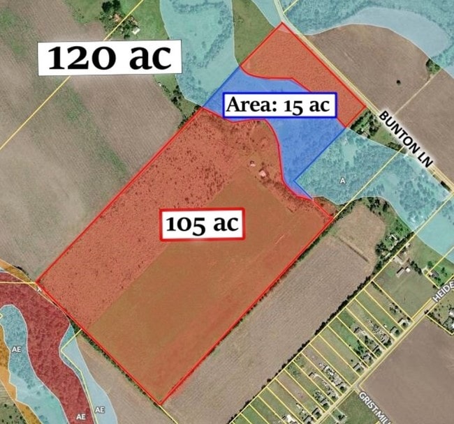
A0367 ALBERT PACE SURVEY, ACRES 105.47
Farms
HAYS
A Areas with a 1% annual chance of flooding and a 26% chance of flooding over the life of a 30-year mortgage.
Texas
2024
105.47 AC
2025
Hays County
010916
Austin
876 SF
Austin-Round Rock-San Marcos, TX
NEARBY LISTINGS FOR SALE OR LEASE
DEMOGRAPHICS near 800 Bunton Ln
1 mile
3 mile
5 mile
2025 Total Population
4,174
37,844
95,320
2030 Population
4,972
44,310
112,116
Pop Growth 2025-2030
+ 19.12%
+ 17.09%
+ 17.62%
Average Age
34
35
35
2025 Total Households
1,290
11,636
31,609
HH Growth 2025-2030
+ 20.08%
+ 18.24%
+ 18.62%
Median Household Inc
$95,432
$93,506
$93,191
Avg Household Size
3.20
3.20
3.00
2025 Avg HH Vehicles
2.00
2.00
2.00
Median Home Value
$341,437
$332,347
$344,998
Median Year Built
2010
2010
2010
Nearby Places
Map Layers
Map Styles
 Street
 Aerial
Transit
 Traffic
 Biking
Places
Listings with unknown addresses are not visible on the map
- Restaurants
- Banks
- Shops
- Fitness
- Groceries
PUBLIC TRANSPORTATION
AIRPORT
Austin-Bergstrom International
Drive
Walk
Distance
Austin-Bergstrom International
40 min
24.9 mi
Freight Ports
Calhoun Port
Drive
Walk
Distance
Calhoun Port
176 min
142.8 mi
SALE & LEASE HISTORY
LISTING DATE
SALE/LEASE

Aug 29, 2019
For Sale
Nearby Properties
Address
Land Use
TOTAL SIZE
Lot Size
Zoning
Address
Land Use
TOTAL SIZE
Lot Size
Zoning
331,761 SF
57.23 AC
Address
Land Use
TOTAL SIZE
Lot Size
Zoning
240,002 SF
53.46 AC
Address
Land Use
TOTAL SIZE
Lot Size
Zoning
158,169 SF
14 AC
Address
Land Use
TOTAL SIZE
Lot Size
Zoning
234,794 SF
10.07 AC
Address
Land Use
TOTAL SIZE
Lot Size
Zoning
212,026 SF
13.82 AC
Address
Land Use
TOTAL SIZE
Lot Size
Zoning
73,518 SF
12.79 AC
Address
Land Use
TOTAL SIZE
Lot Size
Zoning
175,604 SF
11.72 AC
Address
Land Use
TOTAL SIZE
Lot Size
Zoning
50,507 SF
3.19 AC
Address
Land Use
TOTAL SIZE
Lot Size
Zoning
924 SF
166.72 AC
Address
Land Use
TOTAL SIZE
Lot Size
Zoning
63,875 SF
5.82 AC
Address
Land Use
TOTAL SIZE
Lot Size
Zoning
2,663 SF
176.58 AC
Address
Land Use
TOTAL SIZE
Lot Size
Zoning
97,976 SF
12.20 AC
Address
Land Use
TOTAL SIZE
Lot Size
Zoning
672 SF
1.55 AC
Address
Land Use
TOTAL SIZE
Lot Size
Zoning
303.50 AC
Address
Land Use
TOTAL SIZE
Lot Size
Zoning
59.27 AC
Address
Land Use
TOTAL SIZE
Lot Size
Zoning
2,748 SF
72.33 AC
Address
Land Use
TOTAL SIZE
Lot Size
Zoning
16.15 AC
Address
Land Use
TOTAL SIZE
Lot Size
Zoning
26,180 SF
2.86 AC
Address
Land Use
TOTAL SIZE
Lot Size
Zoning
96,000 SF
10 AC
Address
Land Use
TOTAL SIZE
Lot Size
Zoning
1,204 SF
4.86 AC
Address
Land Use
TOTAL SIZE
Lot Size
Zoning
29,171 SF
3.23 AC
Address
Land Use
TOTAL SIZE
Lot Size
Zoning
90,950 SF
6.14 AC
Address
Land Use
TOTAL SIZE
Lot Size
Zoning
49,536 SF
2.36 AC
Address
Land Use
TOTAL SIZE
Lot Size
Zoning
3,510 SF
136.76 AC
Address
Land Use
TOTAL SIZE
Lot Size
Zoning
118.83 AC
Address
Land Use
TOTAL SIZE
Lot Size
Zoning
14,883 SF
14.23 AC
Address
Land Use
TOTAL SIZE
Lot Size
Zoning
36.30 AC
Address
Land Use
TOTAL SIZE
Lot Size
Zoning
47.48 AC
Address
Land Use
TOTAL SIZE
Lot Size
Zoning
76.94 AC
Address
Land Use
TOTAL SIZE
Lot Size
Zoning
7,200 SF
5.01 AC
The World's #1 Commercial Real Estate Marketplace
Connect with us
© 2026 CoStar Group
The information above has been obtained from sources believed reliable. While we do not doubt its accuracy we have not verified it and make no guarantee, warranty or representation about it. It is your responsibility to independently confirm its accuracy and completeness. Any projections, opinions, assumptions, or estimates used are for example only and do not represent the current or future performance of the property. The value of this transaction to you depends on tax and other factors which should be evaluated by your tax, financial, and legal advisors. You and your advisors should conduct a careful, independent investigation of the property to determine to your satisfaction the suitability of the property for your needs.