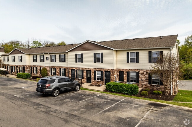
Property Record
800 Cheyenne Blvd, Madison, TN 37115

Property Detail
800 Cheyenne Blvd
052-00-0-052
E/S CHEYENNE BV S OF BUBBLING WELL RD
Apartment
Davidson
RM9
Tennessee
AE The base floodplain where base flood elevations are provided. AE Zones are now used on new format FIRMs instead of A1-A30 Zones.
16.20 AC
2025
Heron Walk
2025
Nashville
010601
Nashville-Davidson--Murfreesboro--Franklin, TN
18,502 SF
NEARBY LISTINGS FOR SALE OR LEASE
DEMOGRAPHICS near 800 Cheyenne Blvd
1 mile
3 mile
5 mile
2025 Total Population
7,313
45,563
121,873
2030 Population
7,568
47,391
127,121
Pop Growth 2025-2030
+ 3.49%
+ 4.01%
+ 4.31%
Average Age
38
40
40
2025 Total Households
2,894
19,419
52,193
HH Growth 2025-2030
+ 3.87%
+ 4.41%
+ 4.70%
Median Household Inc
$61,121
$66,580
$73,557
Avg Household Size
2.50
2.30
2.30
2025 Avg HH Vehicles
2.00
2.00
2.00
Median Home Value
$271,057
$328,634
$376,612
Median Year Built
1985
1979
1980
Nearby Places
Map Layers
Map Styles
 Street
 Aerial
Layers
 Traffic
 Biking
Places
Listings with unknown addresses are not visible on the map
- Restaurants
- Banks
- Shops
- Fitness
- Groceries
PUBLIC TRANSPORTATION
COMMUTER RAIL
Hermitage (East Corridor Line - Tennessee Regional Transportation Authority Music City Star (Music City Star))
Drive
Walk
Distance
Hermitage (East Corridor Line - Tennessee Regional Transportation Authority Music City Star (Music City Star))
16 min
9.3 mi
AIRPORT
Nashville International
Drive
Walk
Distance
Nashville International
25 min
14.9 mi
Nearby Properties
Address
Land Use
TOTAL SIZE
Lot Size
Zoning
Address
Land Use
TOTAL SIZE
Lot Size
Zoning
26,434 SF
12.86 AC
RM20
Address
Land Use
TOTAL SIZE
Lot Size
Zoning
102,738 SF
6.25 AC
MULTIZONE
Address
Land Use
TOTAL SIZE
Lot Size
Zoning
11,088 SF
21.28 AC
RS7.5
Address
Land Use
TOTAL SIZE
Lot Size
Zoning
17,292 SF
12.35 AC
RM20
Address
Land Use
TOTAL SIZE
Lot Size
Zoning
28,547 SF
14.32 AC
SP
Address
Land Use
TOTAL SIZE
Lot Size
Zoning
30,534 SF
19.77 AC
SP
Address
Land Use
TOTAL SIZE
Lot Size
Zoning
336,784 SF
41.54 AC
IR
Address
Land Use
TOTAL SIZE
Lot Size
Zoning
195,436 SF
33.31 AC
CA
Address
Land Use
TOTAL SIZE
Lot Size
Zoning
169,292 SF
12 AC
RM20
Address
Land Use
TOTAL SIZE
Lot Size
Zoning
6,120 SF
17.46 AC
R10
Address
Land Use
TOTAL SIZE
Lot Size
Zoning
186,755 SF
6.08 AC
CA
Address
Land Use
TOTAL SIZE
Lot Size
Zoning
162,261 SF
6.20 AC
RM40
Address
Land Use
TOTAL SIZE
Lot Size
Zoning
13,950 SF
17.60 AC
R8
Address
Land Use
TOTAL SIZE
Lot Size
Zoning
3,312 SF
33.03 AC
IR
Address
Land Use
TOTAL SIZE
Lot Size
Zoning
191,733 SF
62.90 AC
MULTI-ZONE
Address
Land Use
TOTAL SIZE
Lot Size
Zoning
146,323 SF
4.48 AC
RM40
Address
Land Use
TOTAL SIZE
Lot Size
Zoning
34,752 SF
19.09 AC
CS
Address
Land Use
TOTAL SIZE
Lot Size
Zoning
93,000 SF
16.44 AC
IR
Address
Land Use
TOTAL SIZE
Lot Size
Zoning
112,056 SF
40.15 AC
MULTIZONE
Address
Land Use
TOTAL SIZE
Lot Size
Zoning
4,578 SF
17.98 AC
R15
Address
Land Use
TOTAL SIZE
Lot Size
Zoning
22,090 SF
9.18 AC
CA
Address
Land Use
TOTAL SIZE
Lot Size
Zoning
3,864 SF
4.05 AC
RS5
Address
Land Use
TOTAL SIZE
Lot Size
Zoning
49,752 SF
5.36 AC
RS20
Address
Land Use
TOTAL SIZE
Lot Size
Zoning
68,131 SF
4.16 AC
MUL
Address
Land Use
TOTAL SIZE
Lot Size
Zoning
31,008 SF
13.64 AC
RM20
Address
Land Use
TOTAL SIZE
Lot Size
Zoning
22,850 SF
1.91 AC
R10
Address
Land Use
TOTAL SIZE
Lot Size
Zoning
140,913 SF
32.40 AC
MULTI-ZONE
Address
Land Use
TOTAL SIZE
Lot Size
Zoning
102,702 SF
2.38 AC
CA
Address
Land Use
TOTAL SIZE
Lot Size
Zoning
93,232 SF
5.40 AC
RM20
Address
Land Use
TOTAL SIZE
Lot Size
Zoning
22,394 SF
6.11 AC
CA
The World's #1 Commercial Real Estate Marketplace
Connect with us
© 2026 CoStar Group
The information above has been obtained from sources believed reliable. While we do not doubt its accuracy we have not verified it and make no guarantee, warranty or representation about it. It is your responsibility to independently confirm its accuracy and completeness. Any projections, opinions, assumptions, or estimates used are for example only and do not represent the current or future performance of the property. The value of this transaction to you depends on tax and other factors which should be evaluated by your tax, financial, and legal advisors. You and your advisors should conduct a careful, independent investigation of the property to determine to your satisfaction the suitability of the property for your needs.