Property Record
800 10Th St E, Hastings, MN 55033
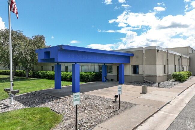


This Property Is For Sale
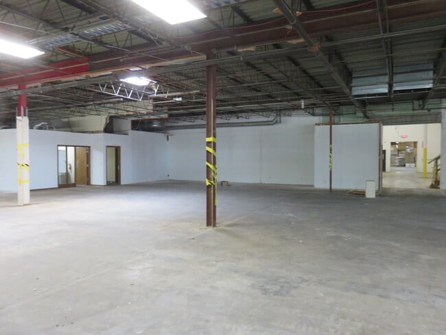
Current Lease Availabilities
Property Detail
800 10Th St E
Minneapolis-St. Paul-Bloomington, MN-WI
PROFILE ADDITION 1 1
19-58800-01-010
DAKOTA
Industrialgeneral
Minnesota
B and X Area of moderate flood hazard, usually the area between the limits of the 100-year and 500-year floods.
10
2024
7.97 AC
2024
South Central
061109
Minneapolis/St Paul
98,580 SF
NEARBY LISTINGS FOR SALE OR LEASE
DEMOGRAPHICS near 800 10Th St E
1 mile
3 mile
5 mile
2025 Total Population
4,122
26,839
31,397
2030 Population
4,248
27,639
32,363
Pop Growth 2025-2030
+ 3.06%
+ 2.98%
+ 3.08%
Average Age
40
42
42
2025 Total Households
1,756
11,001
12,690
HH Growth 2025-2030
+ 3.25%
+ 2.99%
+ 3.09%
Median Household Inc
$82,170
$93,201
$95,804
Avg Household Size
2.30
2.40
2.40
2025 Avg HH Vehicles
2.00
2.00
2.00
Median Home Value
$269,703
$326,167
$339,222
Median Year Built
1961
1985
1985
Nearby Places
Map Layers
Map Styles
 Street
 Aerial
Layers
 Traffic
 Biking
Places
Listings with unknown addresses are not visible on the map
- Restaurants
- Banks
- Shops
- Fitness
- Groceries
PUBLIC TRANSPORTATION
AIRPORT
Minneapolis-St Paul International/Wold-Chamberlain
Drive
Walk
Distance
Minneapolis-St Paul International/Wold-Chamberlain
36 min
25.9 mi
Nearby Properties
Address
Land Use
TOTAL SIZE
Lot Size
Zoning
Address
Land Use
TOTAL SIZE
Lot Size
Zoning
983,000 SF
41.68 AC
Address
Land Use
TOTAL SIZE
Lot Size
Zoning
427,392 SF
54.06 AC
Address
Land Use
TOTAL SIZE
Lot Size
Zoning
177,117 SF
9.08 AC
Address
Land Use
TOTAL SIZE
Lot Size
Zoning
109,735 SF
1.12 AC
Address
Land Use
TOTAL SIZE
Lot Size
Zoning
113,559 SF
6.29 AC
Address
Land Use
TOTAL SIZE
Lot Size
Zoning
115,394 SF
4.74 AC
Address
Land Use
TOTAL SIZE
Lot Size
Zoning
115,250 SF
1.84 AC
Address
Land Use
TOTAL SIZE
Lot Size
Zoning
101,400 SF
3.10 AC
Address
Land Use
TOTAL SIZE
Lot Size
Zoning
135,563 SF
5.86 AC
Address
Land Use
TOTAL SIZE
Lot Size
Zoning
231,675 SF
92.69 AC
Address
Land Use
TOTAL SIZE
Lot Size
Zoning
94,745 SF
8.91 AC
Address
Land Use
TOTAL SIZE
Lot Size
Zoning
231,725 SF
21.06 AC
Address
Land Use
TOTAL SIZE
Lot Size
Zoning
101,769 SF
5.48 AC
Address
Land Use
TOTAL SIZE
Lot Size
Zoning
84,868 SF
5.85 AC
Address
Land Use
TOTAL SIZE
Lot Size
Zoning
117,813 SF
5.49 AC
Address
Land Use
TOTAL SIZE
Lot Size
Zoning
49,205 SF
5.54 AC
Address
Land Use
TOTAL SIZE
Lot Size
Zoning
88,072 SF
18.46 AC
Address
Land Use
TOTAL SIZE
Lot Size
Zoning
49,091 SF
1.27 AC
Address
Land Use
TOTAL SIZE
Lot Size
Zoning
4.69 AC
Address
Land Use
TOTAL SIZE
Lot Size
Zoning
58,296 SF
2.87 AC
Address
Land Use
TOTAL SIZE
Lot Size
Zoning
3.79 AC
Address
Land Use
TOTAL SIZE
Lot Size
Zoning
103,134 SF
4.52 AC
Address
Land Use
TOTAL SIZE
Lot Size
Zoning
74,700 SF
12.15 AC
Address
Land Use
TOTAL SIZE
Lot Size
Zoning
139,140 SF
3.99 AC
Address
Land Use
TOTAL SIZE
Lot Size
Zoning
1.35 AC
Address
Land Use
TOTAL SIZE
Lot Size
Zoning
28,112 SF
146.03 AC
Address
Land Use
TOTAL SIZE
Lot Size
Zoning
125,958 SF
11.06 AC
Address
Land Use
TOTAL SIZE
Lot Size
Zoning
187,654 SF
2.34 AC
Address
Land Use
TOTAL SIZE
Lot Size
Zoning
47,963 SF
2.59 AC
Address
Land Use
TOTAL SIZE
Lot Size
Zoning
48,883 SF
5.65 AC
The World's #1 Commercial Real Estate Marketplace
Connect with us
© 2026 CoStar Group
The information above has been obtained from sources believed reliable. While we do not doubt its accuracy we have not verified it and make no guarantee, warranty or representation about it. It is your responsibility to independently confirm its accuracy and completeness. Any projections, opinions, assumptions, or estimates used are for example only and do not represent the current or future performance of the property. The value of this transaction to you depends on tax and other factors which should be evaluated by your tax, financial, and legal advisors. You and your advisors should conduct a careful, independent investigation of the property to determine to your satisfaction the suitability of the property for your needs.