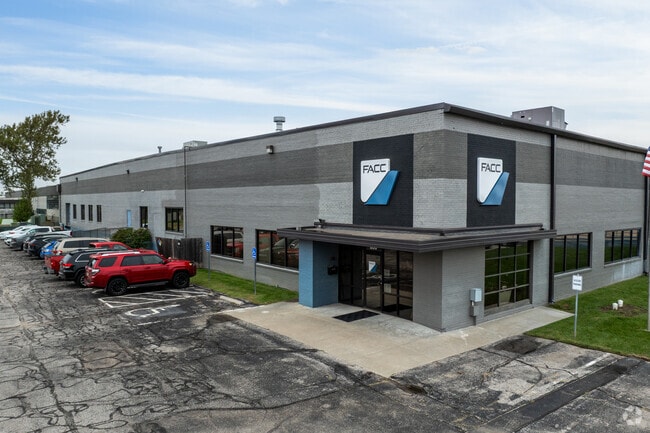
Property Record
800 E 37Th St N, Wichita, KS 67219
NEARBY LISTINGS FOR SALE OR LEASE
Property Detail
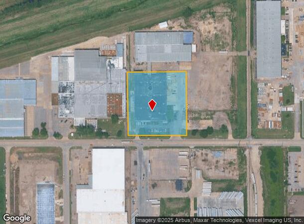
800 E 37Th St N
Wichita, KS
Rl Hayes Add
098-28-0-34-01-002.00
S 392 FT W 365.5 FT LOT 1 R.L. HAYES ADD.
Warehouse
Sedgwick
AH
Kansas
20173C0214G
1
2024
3.31 AC
2025
Northeast
008100
Wichita
58,500 SF
DEMOGRAPHICS near 800 E 37Th St N
1 Mile
3 Mile
5 Mile
2024 Total Population
1,457
40,609
139,288
2029 Population
1,477
41,345
142,665
Pop Growth 2024-2029
+ 1.37%
+ 1.81%
+ 2.42%
Average Age
34
37
38
2024 Total Households
516
15,159
56,184
HH Growth 2024-2029
+ 1.16%
+ 1.62%
+ 2.47%
Median Household Inc
$50,950
$53,042
$54,465
Avg Household Size
2.80
2.60
2.30
2024 Avg HH Vehicles
3.00
2.00
2.00
Median Home Value
$65,753
$125,725
$151,579
Median Year Built
1957
1961
1968
Nearby Places
Map Layers
Map Styles
 Street
 Aerial
- Restaurants
- Banks
- Shops
- Fitness
- Groceries
PUBLIC TRANSPORTATION
AIRPORT
Wichita Dwight D Eisenhower Ntl
DRIVE
WALK
Distance
Wichita Dwight D Eisenhower Ntl
16 min
12.2 mi
SALE & LEASE HISTORY
LISTING DATE
SALE/LEASE

Jun 16, 2017
For Lease
Feb 20, 2018
For Lease
Nearby Properties
Address
Land Use
TOTAL SIZE
Lot Size
Zoning
Address
Land Use
TOTAL SIZE
Lot Size
Zoning
481,160 SF
63.37 AC
SF-5
Address
Land Use
TOTAL SIZE
Lot Size
Zoning
924,000 SF
58.58 AC
SF-20
Address
Land Use
TOTAL SIZE
Lot Size
Zoning
179,764 SF
42.17 AC
SF-5,LI
Address
Land Use
TOTAL SIZE
Lot Size
Zoning
304,863 SF
74.13 AC
SF5
Address
Land Use
TOTAL SIZE
Lot Size
Zoning
305,447 SF
46.77 AC
GI
Address
Land Use
TOTAL SIZE
Lot Size
Zoning
199,468 SF
24.45 AC
SF-5
Address
Land Use
TOTAL SIZE
Lot Size
Zoning
147,784 SF
39.28 AC
SF-5
Address
Land Use
TOTAL SIZE
Lot Size
Zoning
180,598 SF
17.41 AC
SF-5
Address
Land Use
TOTAL SIZE
Lot Size
Zoning
92,973 SF
5.52 AC
PUD
Address
Land Use
TOTAL SIZE
Lot Size
Zoning
64,133 SF
5.93 AC
SF-5
Address
Land Use
TOTAL SIZE
Lot Size
Zoning
66,601 SF
3.85 AC
SF-5
Address
Land Use
TOTAL SIZE
Lot Size
Zoning
72,001 SF
21.99 AC
LI
Address
Land Use
TOTAL SIZE
Lot Size
Zoning
60,945 SF
14.20 AC
SF-5
Address
Land Use
TOTAL SIZE
Lot Size
Zoning
41,798 SF
5.61 AC
PUD
Address
Land Use
TOTAL SIZE
Lot Size
Zoning
87,018 SF
8.38 AC
LC
Address
Land Use
TOTAL SIZE
Lot Size
Zoning
1,179,118 SF
171.49 AC
LI
Address
Land Use
TOTAL SIZE
Lot Size
Zoning
31,655 SF
4.14 AC
GO
Address
Land Use
TOTAL SIZE
Lot Size
Zoning
35,143 SF
0.78 AC
GO
Address
Land Use
TOTAL SIZE
Lot Size
Zoning
66,946 SF
26.81 AC
SF-5,LC
Address
Land Use
TOTAL SIZE
Lot Size
Zoning
87,838 SF
13 AC
SF-5,GO
Address
Land Use
TOTAL SIZE
Lot Size
Zoning
94,251 SF
6.46 AC
C2
Address
Land Use
TOTAL SIZE
Lot Size
Zoning
21,610 SF
4.27 AC
SF-5
Address
Land Use
TOTAL SIZE
Lot Size
Zoning
64,218 SF
2.01 AC
TF-3
Address
Land Use
TOTAL SIZE
Lot Size
Zoning
76,039 SF
9.43 AC
R2
Address
Land Use
TOTAL SIZE
Lot Size
Zoning
27,535 SF
10.54 AC
LC
Address
Land Use
TOTAL SIZE
Lot Size
Zoning
59,790 SF
7.74 AC
SF-5
Address
Land Use
TOTAL SIZE
Lot Size
Zoning
90,680 SF
1.94 AC
SF-5
Address
Land Use
TOTAL SIZE
Lot Size
Zoning
25,748 SF
14.90 AC
MF-18
Address
Land Use
TOTAL SIZE
Lot Size
Zoning
52,947 SF
42.43 AC
B
Address
Land Use
TOTAL SIZE
Lot Size
Zoning
36,825 SF
10.47 AC
LC,SF-5
The World's #1 Commercial Real Estate Marketplace
Connect with us
© 2025 CoStar Group
The information above has been obtained from sources believed reliable. While we do not doubt its accuracy we have not verified it and make no guarantee, warranty or representation about it. It is your responsibility to independently confirm its accuracy and completeness. Any projections, opinions, assumptions, or estimates used are for example only and do not represent the current or future performance of the property. The value of this transaction to you depends on tax and other factors which should be evaluated by your tax, financial, and legal advisors. You and your advisors should conduct a careful, independent investigation of the property to determine to your satisfaction the suitability of the property for your needs.