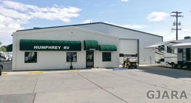
Property Record
800 Highway 50, Grand Junction, CO 81503

NEARBY LISTINGS FOR SALE OR LEASE
Property Detail
800 Highway 50
Grand Junction, CO
Orchard Mesa Heights
2945-261-15-007
THAT PT OF LOTS 27 + 28 N OF HWY + ALL OF LOTS 29 TO 38 BLK 20 ORCHARD MESA HEIGHTS + 40FT ADJ LOT 38 ON N
Commercialnec
Mesa
X
Colorado
08077C0816F
27&28
2023
0.98 AC
2024
Colorado Northwest Area
001304
Other Market Areas
7,521 SF
DEMOGRAPHICS near 800 Highway 50
1 Mile
3 Mile
5 Mile
2024 Total Population
4,718
38,680
91,292
2029 Population
4,929
40,459
95,947
Pop Growth 2024-2029
+ 4.47%
+ 4.60%
+ 5.10%
Average Age
40
40
42
2024 Total Households
2,028
16,017
37,985
HH Growth 2024-2029
+ 4.54%
+ 4.75%
+ 5.24%
Median Household Inc
$53,831
$53,327
$59,662
Avg Household Size
2.30
2.20
2.30
2024 Avg HH Vehicles
2.00
2.00
2.00
Median Home Value
$299,610
$286,642
$315,127
Median Year Built
1983
1974
1984
Nearby Places
Map Layers
Map Styles
 Street
 Aerial
- Restaurants
- Banks
- Shops
- Fitness
- Groceries
PUBLIC TRANSPORTATION
COMMUTER RAIL
Grand Junction Amtrak Station (California Zephyr - Amtrak)
DRIVE
WALK
Distance
Grand Junction Amtrak Station (California Zephyr - Amtrak)
4 min
1.9 mi
AIRPORT
Grand Junction Regional
DRIVE
WALK
Distance
Grand Junction Regional
15 min
6.6 mi
Freight Ports
Port of Long Beach
DRIVE
WALK
Distance
Port of Long Beach
820 min
790.9 mi
SALE & LEASE HISTORY
LISTING DATE
SALE/LEASE

Sep 25, 2016
For Lease
Sep 23, 2016
For Sale
Nearby Properties
Address
Land Use
TOTAL SIZE
Lot Size
Zoning
Address
Land Use
TOTAL SIZE
Lot Size
Zoning
365,495 SF
20.90 AC
CSR
Address
Land Use
TOTAL SIZE
Lot Size
Zoning
482,392 SF
24.70 AC
CSR
Address
Land Use
TOTAL SIZE
Lot Size
Zoning
429,786 SF
16.99 AC
CSR
Address
Land Use
TOTAL SIZE
Lot Size
Zoning
444,676 SF
29.47 AC
CSR
Address
Land Use
TOTAL SIZE
Lot Size
Zoning
181,976 SF
14.80 AC
CSR
Address
Land Use
TOTAL SIZE
Lot Size
Zoning
180,396 SF
17.75 AC
CSR
Address
Land Use
TOTAL SIZE
Lot Size
Zoning
227,855 SF
37.91 AC
Address
Land Use
TOTAL SIZE
Lot Size
Zoning
75,770 SF
82.62 AC
CSR
Address
Land Use
TOTAL SIZE
Lot Size
Zoning
130,260 SF
0.20 AC
C-1
Address
Land Use
TOTAL SIZE
Lot Size
Zoning
127,269 SF
3.21 AC
B-2
Address
Land Use
TOTAL SIZE
Lot Size
Zoning
113,925 SF
0.16 AC
PD
Address
Land Use
TOTAL SIZE
Lot Size
Zoning
69,390 SF
0.14 AC
C-1
Address
Land Use
TOTAL SIZE
Lot Size
Zoning
94,639 SF
0.16 AC
C-1
Address
Land Use
TOTAL SIZE
Lot Size
Zoning
126,114 SF
13.75 AC
B-2
Address
Land Use
TOTAL SIZE
Lot Size
Zoning
66,178 SF
2.02 AC
PD
Address
Land Use
TOTAL SIZE
Lot Size
Zoning
86,946 SF
5.52 AC
C-1
Address
Land Use
TOTAL SIZE
Lot Size
Zoning
83,518 SF
1.45 AC
CSR
Address
Land Use
TOTAL SIZE
Lot Size
Zoning
70,394 SF
6.19 AC
PD
Address
Land Use
TOTAL SIZE
Lot Size
Zoning
215,583 SF
20.40 AC
C-1
Address
Land Use
TOTAL SIZE
Lot Size
Zoning
85,303 SF
8.45 AC
C-2
Address
Land Use
TOTAL SIZE
Lot Size
Zoning
87,806 SF
0.11 AC
Address
Land Use
TOTAL SIZE
Lot Size
Zoning
33,450 SF
86.40 AC
PUD
Address
Land Use
TOTAL SIZE
Lot Size
Zoning
222,950 SF
17.36 AC
C-1
Address
Land Use
TOTAL SIZE
Lot Size
Zoning
164,850 SF
13.33 AC
C-1
Address
Land Use
TOTAL SIZE
Lot Size
Zoning
45,000 SF
0.20 AC
Address
Land Use
TOTAL SIZE
Lot Size
Zoning
91,623 SF
2.33 AC
B-2
Address
Land Use
TOTAL SIZE
Lot Size
Zoning
142,425 SF
19.91 AC
C-2
Address
Land Use
TOTAL SIZE
Lot Size
Zoning
68,700 SF
0.16 AC
Address
Land Use
TOTAL SIZE
Lot Size
Zoning
49,222 SF
15 AC
The World's #1 Commercial Real Estate Marketplace
Connect with us
© 2025 CoStar Group
The information above has been obtained from sources believed reliable. While we do not doubt its accuracy we have not verified it and make no guarantee, warranty or representation about it. It is your responsibility to independently confirm its accuracy and completeness. Any projections, opinions, assumptions, or estimates used are for example only and do not represent the current or future performance of the property. The value of this transaction to you depends on tax and other factors which should be evaluated by your tax, financial, and legal advisors. You and your advisors should conduct a careful, independent investigation of the property to determine to your satisfaction the suitability of the property for your needs.